Related Research Articles

The Antofagasta Region is one of Chile's sixteen first-order administrative divisions. The second-largest region of Chile in area, it comprises three provinces, Antofagasta, El Loa and Tocopilla. It is bordered to the north by Tarapacá, by Atacama to the south, and to the east by Bolivia and Argentina. The region's capital is the port city of Antofagasta; another one of its important cities is Calama. The region's main economic activity is copper mining in its giant inland porphyry copper systems.

The Atacama Region is one of Chile's 16 first order administrative divisions. It comprises three provinces: Chañaral, Copiapó and Huasco. It is bordered to the north by Antofagasta, to the south by Coquimbo, to east with Provinces of Catamarca, La Rioja and San Juan of Argentina, and to the west by the Pacific Ocean. The regional capital Copiapó is located at 806 km (501 mi) north of the country's capital of Santiago. The region occupies the southern portion of the Atacama Desert, the rest of the desert is mainly distributed among the other regions of Norte Grande.
Codelco is a Chilean state-owned copper mining company. It was formed in 1976 from foreign-owned copper companies that were nationalised in 1971.
La Serena is a city and commune in northern Chile, capital of the Coquimbo Region. Founded in 1544, it is the country's second oldest city after the national capital, Santiago. As of 2012, it had a communal population of roughly 200,000, and was one of the fastest-growing areas of Chile.
CAP is a Chilean holding company of the mining and steel sectors. These sectors are represented by different affiliates.

Sierra Menera is a 31 km (19 mi) long mountain range in the southwestern end of the Iberian System.

The history of rail transport in Chile has gone through several periods of boom and bust. It began in 1840, with the construction by William Wheelwright of the first branch in the north. Further construction proceeded apace linking cities from Pisagua all the way to Puerto Montt.

Between 1830 and 1850, Chilean silver mining grew at an unprecedented pace which transformed mining into one of the country's principal sources of wealth. The rush caused rapid demographic, infrastructural, and economic expansion in the semi-arid Norte Chico mountains where the silver deposits lay. A number of Chileans made large fortunes in the rush and made investments in other areas of the economy of Chile. By the 1850s, the rush was in decline and lucrative silver mining definitively ended in the 1870s. At the same time, mining activity in Chile reoriented to saltpetre operations.
The Compañía de Acero del Pacífico, also known by its acronym CAP, is the main iron and steel industry of Chile with its main facilities at Huachipato near the port of Talcahuano in Bío Bío Region.

The mining industry of Morocco is important to the national economy. Morocco is the world's largest producer of phosphate, and contains about 75% of the world's estimated reserves. Mining contributed up to 35% of exports and 5% of GDP in 2011. Foreign investors have found the investment climate, the infrastructure, fiscal situation, and political stability very favorable to continue business in the country in this sector.

Huachipato is census district and neighbourhood in Talcahuano Commune, part of the conurbation of Greater Concepción in the Biobío Region of southern Chile. It is the industrialized part of the commune supporting a steel mill and oil refinery.
During most of Chile's history, from 1500 to the present, mining has been an important economic activity. 16th century mining was oriented towards the exploitation of gold placer deposits using encomienda labour. After a period of decline in the 17th century mining resurged in the 18th and early 19th century this time revolving chiefly around silver. In the 1870s silver mining declined sharply. Chile took over the highly lucrative saltpetre mining districts of Peru and Bolivia in the War of the Pacific (1879–83). In the first half of the 20th century copper mining overshadowed the declining saltpetre mining.

El Laco is a volcanic complex in the Antofagasta Region of Chile. It is directly south of the Cordón de Puntas Negras volcanic chain. Part of the Central Volcanic Zone of the Andes, it is a group of seven stratovolcanoes and a caldera. It is about two million years old. The main summit of the volcano is a lava dome called Pico Laco, which is variously reported to be 5,325 metres (17,470 ft) or 5,472 metres (17,953 ft) high. The edifice has been affected by glaciation, and some reports indicate that it is still fumarolically active.

Charles Saint Lambert was a Franco-Chilean mining engineer and businessman. He explored the mineral deposits in northern Chile and introduced the reverberatory furnace which transformed the Chilean copper mining industry by making it practical to exploit previously discarded aggregations of relatively low-grade copper slag. Copper production increased six-fold in just thirty years.
The Chilean Iron Belt is a geological province rich in iron ore deposits in northern Chile. It extends as a north-south beld along the western part of the Chilean regions of Coquimbo and Atacama, chiefly between the cities of La Serena and Taltal. The belt follows much of the Atacama Fault System and is about 600 km long and 25 km broad.
Andes Iron is a Chilean exploration and mining company with two major projects in Chile. The Dominga project is a proposed open-pit copper mine with accompanying processing plant, desalination plant, slurry pipelines and an export port.
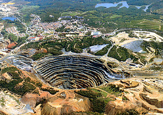
El Romeral is an iron mine in north-central Chile. The mine benefits from being located only 22 km NNE of the city of La Serena and being next to Guayacán, a port with conditions for high-tonnage cargo ships. The mine emerged as a replacement for the nearby mine of El Tofo that was close to depletion in the early 1950s. El Romeral was Bethehem Chile Iron Mines last major investment as Compañía de Acero del Pacífico obtained the ownership of El Tofo and El Romeral in the early 1971 when they were nationalized during the Presidency of Salvador Allende. Despite being initially an expensive mine in terms of infrastructure investment and having a troublesome geology El Romeral proved with time to host more iron than initially thought. Following an ownership restructuring Compañía Minera del Pacífico, now holds control of the mine. During the 1970s El Romeral would produce enough iron to fully supply the steel mill of Huachipato. From the 1970s onward El Romeral came to overshadow El Algarrobo mine in iron production.
La Liga Formation is a geologic formation Late Jurassic and Early Cretaceous age cropping out in Coquimbo Region, Chile. Rocks of the formation are andesites. Locally the rocks of the formation present epidote alteration. The iron ores of El Romeral mine are emplaced on La Liga Formation.
El Algarrobo is an iron mine in north-central Chile. Geologically it is an iron oxide-apatite (IOA) type of deposit. El Algarrobo is part of a wider province of iron ores known as the Chilean Iron Belt. From the 1970s onward El Romeral have come to overshadow El Algarrobo in iron ore production.
The Riotinto-Nerva mining basin is a Spanish mining area located in the northeast of the province of Huelva (Andalusia), which has its main population centers in the municipalities of El Campillo, Minas de Riotinto and Nerva, in the region of the Cuenca Minera. It is also part of the Iberian Pyrite Belt.
References
- ↑ "El Tofo mine, Elqui Province, Coquimbo Region, Chile". mindat.org. Retrieved 2019-12-01.
Old Fe open cast mine, now reopening: mineralization hosted in porhyr, diorite and amphibolized rocks.
- 1 2 Barra, Fernando; Reich, M.; Selby, D.; Rojas, P.; Simon, A.; Salazar, E.; Palma, G. (2017). "Unraveling the origin of the Andean IOCG clan: a Re-Os isotope approach" (PDF). Ore Geology Reviews. 81 (1): 62–78.
- 1 2 3 4 5 "Historia de la mina de hierro El Tofo". Museo Histórico Gabriel González Videla (in Spanish). Servicio Nacional del Patrimonio Cultural. 2019-12-01.
- 1 2 Couyoumdjian, Juan Ricardo (2000). "AUGUSTO MILLAN, Historia de la minería del hierro en Chile. Santiago, Editorial Universitaria, 1999, 220 páginas". Historia (in Spanish). 33. doi: 10.4067/S0717-71942000003300012 .
29°27′S71°15′W / 29.45°S 71.25°W
| | This Coquimbo Region location article is a stub. You can help Wikipedia by expanding it. |