
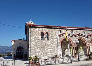
Pyrgos is a city in the northwestern Peloponnese, Greece, capital of the regional unit of Elis and the seat of the Municipality of Pyrgos. The city is located in the middle of a plain, 4 kilometres from the Ionian Sea. The river Alfeios flows into sea about 7 km (4 mi) south of Pyrgos. The population of the town Pyrgos is 25,180, and of the municipality 47,995 (2011). Pyrgos is 16 km (10 mi) west of Olympia, 16 km (10 mi) southeast of Amaliada, 70 km (43 mi) southwest of Patras and 85 km (53 mi) west of Tripoli.
Meropi is a village and a community in the municipality of Oichalia, in Messenia, Greece. It is located in the plains of northern Messenia, west of the Taygetus mountains. It is near a major highway linking Kalamata and Corinth, the Greek National Road 7. It is 1.5 km south of Oichalia, 3.5 km northeast of Meligalas, 21 km southwest of Megalopoli and 26 km north of Kalamata. In 2011 its population was 485 for the village, and 603 for the community, which consists of the villages Meropi, Allagi and Mousta.

Kechries is a village in the municipality of Corinth in Corinthia in Greece, part of the community of Xylokeriza. Population 238 (2011). It takes its name from the ancient port town Kenchreai or Cenchreae, which was situated at the same location.
Arachovitika is a village and a community in the municipal unit of Rio in the northern part of Achaea, Greece. It is situated on the Gulf of Corinth, 1 km northwest of Drepano and 6 km northeast of Rio. The Greek National Road 8A passes south of the village, and the railway Patras - Corinth runs through the village. The community consists of the villages Arachovitika and Kato Arachovitika. There is a port next to Cape Drepano.
Perachora is an inland settlement in Loutraki-Perachora-Agioi Theodoroi, Corinthia, in the region of Peloponnese in Greece. In Antiquity it was called Peiraion.

Diakopto is a coastal town in Achaea, West Greece, Greece. Since the 2011 local government reforms it is a municipal unit of the Aigialeia municipality. The municipal unit has an area of 103.932 km2. The town of Diakopto is situated on the Gulf of Corinth, near the mouth of the Vouraikos river and at the lower end of the Vouraikos Gorge. The 750 mm gauge Diakofto–Kalavryta Railway built in 1885 leads up to the town of Kalavryta passing the Mega Spilaio Monastery at about halfway. Diakopto is on the old Greek National Road 8 ; the new Greek National Road 8A passes 1 km to the south. Diakopto is located about 40 km east of Patras, and 15 km southeast of Aigio.
Eliki, is a village and a community in the municipal unit of Diakopto, Achaea, Greece. It was named after the nearby ancient town Helike. Eliki is located near the river Selinountas and the Gulf of Corinth. It is 5 km (3.1 mi) southeast of Aigio and 7 km (4.3 mi) west of Diakopto. Nea Keryneia is adjacent to the east. The community includes the small village Kalanteri. The Greek National Road 8A passes south of the village.
Platanos is a village and a community in the municipal unit of Akrata, Achaea, Greece. The community includes the mountain villages Ano Potamia, Korinthiako Balkoni and Tsivlos. Platanos lies at about 270 m elevation on a mountain slope directly above the seaside village Paralia Platanou. The villages Ano Potamia and Tsivlos are about 10 km south of Platanos. Platanos is 5 km west of Akrata and 18 km southeast of Aigio. The Greek National Road 8A and the railway Corinth - Patras pass north of Platanos.
Rodia is a town in the municipal unit of Diakopto, Achaea, Greece. It is located in the coastal plains near the Gulf of Corinth, 4 km northwest of Diakopto and 8 km southeast of Aigio. Rodia has a football/soccer team known as Floga and it has a communal soccer field.
Trapeza is a village and a community in the municipal unit of Diakopto, Achaea, Greece. It is located 4 km southeast of Diakopto and 8 km west of Akrata. The community includes the village Paralia Trapezis. Between 1892 and 1940, its name was Nea Voura.
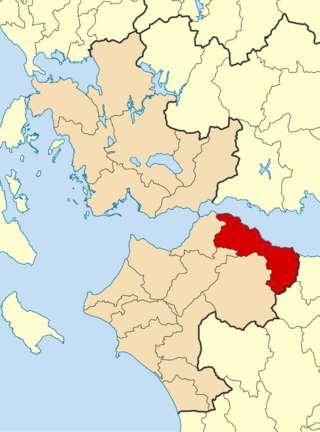
Aigialeia is a municipality and a former province (επαρχία) in the eastern part of the Achaea regional unit, Greece. The seat of the municipality is the town Aigio. The municipality has an area of 723.063 km2. The main towns are Aigio, Akrata and Diakopto. The municipality Aigialeia stretches from the south coast of the Gulf of Corinth to the mountainous interior of the Peloponnese peninsula. The main rivers of the municipality are the Selinountas and the Vouraikos.
Keryneia is a village and a community in the municipal unit of Diakopto, Achaea, Greece. The community consists of the villages Keryneia and Nea Keryneia. It is located 6 km southeast of Aigio and 7 km west of Diakopto. The Greek National Road 8A passes between Keryneia and Nea Keryneia. The town takes its name from the ancient town of Ceryneia
Ano Diakopto is a village and a community in the municipal unit of Diakopto, Achaea, Greece. It is 6 km southeast of Diakopto. The community includes the village of Pounta. Ano Diakopto suffered damage from the 2007 Greek forest fires.

Mamousia is a village and a community in the municipal unit of Diakopto, Achaea, Greece. It is 6 km southwest of Diakopto, on the west side of the Vouraikos gorge. The community includes the villages Derveni and Stavria.
Zachloritika is a village and community in the municipal unit of Diakopto, Achaea, Greece. It is located on the left bank of the river Vouraikos, 1 km west of Diakopto. The Greek National Road 8A passes south of the village.
Nikolaiika is a village in the municipal unit of Diakopto, Achaea, Greece. It is located near the Gulf of Corinth coast, 1 km east of Rizomylos, 5 km west of Diakopto and 7 km southeast of Aigio. The Greek National Road 8A passes south of the village.
Rizomylos is a village in the municipal unit of Diakopto, Achaea, Greece. Its beach on the Gulf of Corinth, 2 km northeast of the village, is well known. Aigio is 6 km to the northwest, and the village Nea Keryneia is adjacent to the west. The Greek National Road 8A passes south of the village.
Kato Zachlorou is a village and a community in eastern Achaea, Greece. It is built on a mountain slope on the left bank of the river Vouraikos, which forms a narrow gorge. The community consists of the villages Kato Zachlorou and Ano Zachlorou, and the Mega Spilaio monastery. It is 11 km south of Diakopto, and 9 km northeast of Kalavryta. In 2011 Kato Zachlorou had a population of 38 for the village, and 53 for the community. The narrow gauge Diakofto–Kalavryta Railway runs through the village.
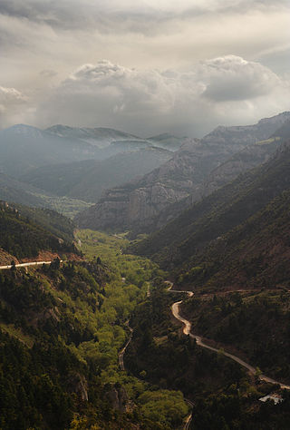
The Vouraikos is a river in Achaea, Greece. In ancient times it was called Erasinos. Its source is in the Aroania mountains, near the village of Priolithos. It flows past the towns of Kalavryta and Diakopto, and flows into the Gulf of Corinth near Diakopto. It is 37.5 km (23.3 mi) long. The name is derived from Boura, a mythological daughter of Ion and Helice who was beloved by Hercules, who according to legend opened the gorge in order to get close to her. This is the Vouraikos gorge, which has a length of about 20 km. In the gorge the river passes along dense vegetation and steep cliffs, waterfalls and caves. The Diakofto–Kalavryta Railway passes through the Vouraikos gorge.


