
Eldorado at Santa Fe is a census-designated place (CDP) in Santa Fe County, New Mexico, United States. It is part of the Santa Fe, New Mexico Metropolitan Statistical Area. The population was 6,130 at the 2010 census.

Eldorado is a city in and the county seat of Schleicher County, Texas, United States. The population was 1,951 at the 2010 census. Eldorado is located on U.S. Highway 277 some 21 miles (34 km) north of Sonora and 43 miles (69 km) south of San Angelo, Texas.

The Cadillac Eldorado is a personal luxury car that was manufactured and marketed by Cadillac from 1952 to 2002 over ten generations. Competitors and similar vehicles included the Continental Mark series, Buick Riviera, Oldsmobile Toronado and Chrysler's Imperial Coupe.

Eldorado Gold Corporation is a Canadian mid-cap gold mining company. It has assets in Canada, Turkey, Greece, Romania, Brazil and Serbia. Eldorado's activities involve all facets of mining, including exploration, development, production and reclamation.

Eldorado was a British soap opera created by Tony Holland from an original idea by John Dark and Verity Lambert that ran for only one year, from 6 July 1992 to 9 July 1993. Set in the fictional town of Los Barcos on the Costa Eldorado in Spain and following the lives of British and European expatriates, the BBC hoped it would be as successful as EastEnders and replicate some of the sunshine and glamour of imported Australian soaps such as Home and Away and Neighbours. A co-production between the BBC and independent production company Cinema Verity and J.Dark y J.Todesco, Eldorado aired three times a week in a high-profile evening slot on the mainstream channel BBC1, filling the slot vacated by Terry Wogan's chat show Wogan, on Mondays, Wednesdays and Fridays at 7.00pm.

Eldorado is a municipality in the state of São Paulo in Brazil. The population is 15,339 in an area of 1654 km². Eldorado is one of 29 cities in São Paulo officially recognized as a touristic city, which gives it extra funding.

Eldorado is an EP released only in Japan and Australia by Neil Young backed by The Restless, which consisted of Chad Cromwell and Rick Rosas.

Eldorado National Forest is a U.S. National Forest located in the central Sierra Nevada mountain range, in eastern California.

Maryland Route 313 is a state highway located on the Eastern Shore of Maryland in the United States. The 75.72-mile (121.86 km) route runs from U.S. Route 50 in Mardela Springs, Wicomico County north to MD 213 and MD 290 in Galena, Kent County. It is predominantly a rural two-lane road that runs through agricultural areas a short distance west of the Delaware border, with the exception of a four-lane divided bypass of Denton shared with MD 404. MD 313 serves many communities, including Sharptown, Eldorado, Federalsburg, Denton, Greensboro, Goldsboro, Barclay, Sudlersville, Millington, and Massey. The route intersects many major roads, including MD 54 in Mardela Springs, MD 404 in the Denton area, MD 302 in Barclay, MD 300 in Sudlersville, and US 301 near Massey.

USS Eldorado (AGC-11) was a Mount McKinley-class amphibious force command ship, named after a mountain range in Nevada. The ship was designed as an amphibious force flagship, a floating command post with advanced communications equipment and extensive combat information spaces to be used by the amphibious forces commander and landing force commander during large-scale operations.

Eldorado Resort Casino is a hotel and casino located in Downtown Reno, Nevada. It anchors a network of connected hotel-casinos in the downtown Reno core that included Circus Circus Reno and Silver Legacy Reno and are owned and operated by Eldorado Resorts.

"Eldorado" is a poem written by Edgar Allan Poe, first published in April 1849.
Highway 962 is an isolated provincial highway in the far north region of the Canadian province of Saskatchewan. For part of the year the highway is not connected to any other highway in the province, but during the winter months a winter road forms allowing access to Fond-du-Lac and other communities to the east. Highway 962 is about 40 km (25 mi) long.

Eldorado Canyon State Park is part of the Colorado State Park system. It is located in Boulder County near the city of Boulder. The park consists of two areas, the Inner Canyon and Crescent Meadows. The park encompasses 885 acres (3.6 km2) with a variety of recreation opportunities available. Eldorado Canyon is home to one of the world's most accessible and comprehensive rock climbing areas. This state park is open during daylight hours only, visitors are expected to leave before dusk. A fee is required for entry, except on Colorado Day when all state parks are free.
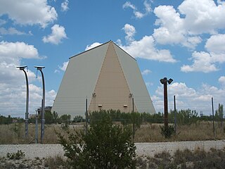
Eldorado Air Force Station located 35 miles south of San Angelo, Texas was one of the four unique AN/FPS-115 PAVE PAWS, early-warning phased-array radar systems. The 8th Space Warning Squadron, 21st Space Wing, Air Force Space Command operated at Eldorado Air Force Station.

Eldorado Mountain is a mountain summit on the eastern flank of the Front Range of the Rocky Mountains of North America. The 8,344-foot (2,543 m) peak is located 8.1 miles (13.1 km) south by west of downtown Boulder, Colorado, United States. The mountain is largely in Boulder County but it straddles the border and its southern flanks are located in Jefferson County. Its name was probably borrowed from the nearby community of Eldorado Springs.

The Eldorado Mountains, also called the El Dorado Mountains, are a north-south trending mountain range in southeast Nevada bordering west of the south-flowing Colorado River; the endorheic Eldorado Valley borders the range to the west, and the range is also on the western border of the Colorado River's Black Canyon of the Colorado, and El Dorado Canyon on the river. The range is 50 miles (80 km) southeast of Las Vegas, Nevada; and the Eldorado Mountains connect with the Highland and Newberry mountains.

The Mokelumne Wilderness is a 105,165-acre (425.59 km2) federally designated wilderness area located 70 miles (110 km) east of Sacramento, California. It is within the boundaries of three national forests: Stanislaus, Eldorado and Toiyabe. First protected under the Wilderness Act of 1964, the Mokelumne’s borders were expanded under the California Wilderness Act of 1984 with the addition of 55,000 acres. The wilderness takes its name from the Mokelumne River, which was named after a Mi-wok Indian village located on the riverbank in California's Central Valley.

Eldorado is an unincorporated community located in the town of Eldorado, Fond du Lac County, Wisconsin, United States. Eldorado is 2.5 miles (4.0 km) east-northeast of Rosendale. Eldorado has a post office with ZIP code 54932.
El Dorado is a mythical city of gold.

