Related Research Articles

Mount St. Helens is an active stratovolcano located in Skamania County, Washington, in the Pacific Northwest region of the United States. It lies 52 miles (83 km) northeast of Portland, Oregon, and 98 miles (158 km) south of Seattle. Mount St. Helens takes its English name from that of the British diplomat Alleyne Fitzherbert, 1st Baron St Helens, a friend of explorer George Vancouver who surveyed the area in the late 18th century. The volcano is part of the Cascade Volcanic Arc, a segment of the Pacific Ring of Fire.

The Cascade Range or Cascades is a major mountain range of western North America, extending from southern British Columbia through Washington and Oregon to Northern California. It includes both non-volcanic mountains, such as many of those in the North Cascades, and the notable volcanoes known as the High Cascades. The small part of the range in British Columbia is referred to as the Canadian Cascades or, locally, as the Cascade Mountains. The highest peak in the range is Mount Rainier in Washington at 14,411 feet (4,392 m).

Orting is a city in Pierce County, Washington, United States. The population was 9,041 at the 2020 census.

Puyallup is a city in Pierce County, Washington, United States, located about 10 miles (16 km) southeast of Tacoma and 35 miles (56 km) south of Seattle. It had a population of 42,973 at the 2020 census. The city's name comes from the Puyallup Tribe of Native Americans and means "the generous people." Puyallup is home to the Washington State Fair, the state's largest fair. The name of the city is notably used in mailing addresses for adjacent unincorporated areas, such as the larger-populated South Hill.

Sumner is a city in northern Pierce County, Washington, United States. The population was 10,621 at the 2020 census. Nearby cities include Puyallup to the west, Auburn to the north, and Bonney Lake to the east.
A lahar is a violent type of mudflow or debris flow composed of a slurry of pyroclastic material, rocky debris and water. The material flows down from a volcano, typically along a river valley.

Nevado del Ruiz, also known as La Mesa de Herveo is a volcano on the border of the departments of Caldas and Tolima in Colombia, being the highest point of both. It is located about 130 km (81 mi) west of the capital city Bogotá. It is a stratovolcano composed of many layers of lava alternating with hardened volcanic ash and other pyroclastic rocks. Volcanic activity at Nevado del Ruiz began about two million years ago, during the Early Pleistocene or Late Pliocene, with three major eruptive periods. The current volcanic cone formed during the present eruptive period, which began 150,000 years ago.

Glacier Peak or Dakobed is the most isolated of the five major stratovolcanoes of the Cascade Volcanic Arc in the U.S state of Washington. Located in the Glacier Peak Wilderness in Mount Baker–Snoqualmie National Forest, the volcano is visible from the west in Seattle, and from the north in the higher areas of eastern suburbs of Vancouver such as Coquitlam, New Westminster and Port Coquitlam. The volcano is the fourth tallest peak in Washington state, and not as much is known about it compared to other volcanoes in the area. Local Native Americans have recognized Glacier Peak and other Washington volcanoes in their histories and stories. When American explorers reached the region, they learned basic information about surrounding landforms, but did not initially understand that Glacier Peak was a volcano. Positioned in Snohomish County, the volcano is only 70 miles (110 km) northeast of downtown Seattle. From locations in northern Seattle and northward, Glacier Peak is closer than the more famous Mount Rainier (Tahoma), but as Glacier Peak is set farther into the Cascades and almost 4,000 feet (1,200 m) shorter, it is much less noticeable than Mount Rainier.
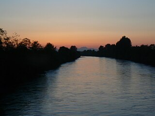
The Puyallup River is a river in the U.S. state of Washington. About 45 miles (72 km) long, it is formed by glaciers on the west side of Mount Rainier. It flows generally northwest, emptying into Commencement Bay, part of Puget Sound. The river and its tributaries drain an area of about 948 square miles (2,460 km2) in Pierce County and southern King County.

Spirit Lake is a lake in Skamania County, Washington, United States, located north of Mount St. Helens. It was a popular tourist destination for many years until Mount St. Helens erupted in 1980. Previously there had been six camps on the shore of Spirit Lake: Boy Scout, the Girl Scout Camp at Spirit Lake, two YMCA camps, Harmony Fall Lodge, and another for the general public. There were also several lodges accessible to visitors, including Spirit Lake Lodge and Mt. St. Helens Lodge. The latter was owned and operated by Harry R. Truman, a noted victim of the volcano's 1980 eruption.

The Cascade Volcanoes are a number of volcanoes in a volcanic arc in western North America, extending from southwestern British Columbia through Washington and Oregon to Northern California, a distance of well over 700 miles (1,100 km). The arc formed due to subduction along the Cascadia subduction zone. Although taking its name from the Cascade Range, this term is a geologic grouping rather than a geographic one, and the Cascade Volcanoes extend north into the Coast Mountains, past the Fraser River which is the northward limit of the Cascade Range proper.

Mount Rainier, also known as Tahoma, is a large active stratovolcano in the Cascade Range of the Pacific Northwest in the United States. The mountain is located in Mount Rainier National Park about 59 miles (95 km) south-southeast of Seattle. With a summit elevation of 14,399.6 ft (4,389 m), it is the highest mountain in the U.S. state of Washington, the most topographically prominent mountain in the contiguous United States, and the tallest in the Cascade Volcanic Arc.
The Mount Rainier Volcano Lahar Warning System consists of two separate components, operating in tandem: Acoustic Flow Monitors (AFM) and the All Hazard Alert Broadcast (AHAB) sirens. The AFM system was developed by the United States Geological Survey (USGS) in 1998 and is now maintained by Pierce County Emergency Management. The purpose of the warning system is to assist in the evacuation of residents in the river valleys around Mount Rainier, a volcano in Washington, in the event of a lahar. Pierce County works in partnership with the USGS, the Pacific Northwest Seismic Network (PNSN), Washington Military Department's Emergency Management Division, and South Sound 9-1-1 to monitor and operate the system.

Kautz Creek is a tributary of the Nisqually River, flowing from the Kautz Glacier, with its watershed in the Mount Rainier National Park of Washington. It drains southwest from Mount Rainier for about 6 miles (9.7 km) before it joins the Nisqually River near Mount Rainier Highway. It is notable for being a severe flooding hazard due to the volume of summer glacier melt and its frequently changing course. The 400-foot (120 m) Kautz Creek Falls on the headwaters of the creek was formed by the retreat of the Kautz Glacier in the past 50 years.

Specimen Ridge, el. 8,379 feet (2,554 m) is an approximately 8.5-mile (13.7 km) ridge along the south rim of the Lamar Valley in Yellowstone National Park. The ridge separates the Lamar Valley from Mirror Plateau. The ridge is oriented northwest to southeast from the Tower Junction area to Amethyst Mountain. The ridge is known for its abundance of amethyst, opal and petrified wood. It was referred to as Specimen Mountain by local miners and was probably named by prospectors well before 1870. The south side of the ridge is traversed by the 18.8-mile (30.3 km) Specimen Ridge Trail between Tower Junction and Soda Butte Creek. The trail passes through the Petrified Forest and over the summit of Amethyst Mountain el. 9,614 feet (2,930 m).

The Muddy River is a stream, about 29 miles (47 km) long, southeast of Mount St. Helens in the U.S. state of Washington. The Muddy River flows south–southeast and joins the Lewis River just above the Swift Reservoir. The Lewis River flows west and is a tributary to the Columbia River. The east flank of Mount St. Helens is within the watershed of Muddy Creek.

Lake Kapowsin is a lake in Pierce County, Washington, about halfway between Tacoma on Puget Sound, and Mount Rainier in the Cascade Mountains. The lake is 2.5 miles (4.0 km) long and 0.15–0.5 miles (0.24–0.80 km) wide, lying in a channel formed by meltwater from the Puget lobe of the Vashon glacier during the Pleistocene glaciation. A small island, Jaybird Island, lies in the northern half of the lake. As indicated by a drowned forest in the lake and other evidence, the Puyallup River was inundated about 550 years ago by a lahar from Mount Rainier called the Electron Mudflow. The mudflow partially filled the channel and blocked Ohop Creek's outlet, forming present-day Lake Kapowsin.
The Bridge for Kids is a proposed bridge across the Carbon River in Orting, Washington, about a mile upstream of where it joins the Puyallup River. It would provide an emergency evacuation route for school children to escape a future lahar flow from Mount Rainier, consisting of an up to 10-meter (33 ft) high flood of mud, rock and boulders. As of 2016, the $40 million bridge was still in the planning phase.
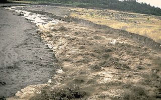
The Osceola Mudflow, also known as the Osceola Lahar, was a debris flow and lahar in the U.S. state of Washington that descended from the summit and northeast slope of Mount Rainier, a volcano in the Cascade Range during a period of eruptions about 5,600 years ago. It traveled down the west and main forks of the White River, passed the location of present-day Enumclaw then reached Puget Sound in several areas, including near the present day sites of Tacoma and Auburn.

The Trout Lake Mudflow was a lahar in the U.S. state of Washington that descended from Mount Adams about 6,000 years ago. It was the largest lahar at Mount Adams since the end of the last ice age, having emplaced about 66,000,000 m3 (2.3×10⁹ cu ft) of mud and rock in a deposit covering more than 16 km2 (6.2 sq mi) of the White Salmon River valley near Trout Lake. The mudflow began as a slope failure high on the southwest flank of Mount Adams where the accumulation zone of the White Salmon and Avalanche glaciers are now located, flowed down tributaries to the White Salmon River, then followed the river valley southward. Husum, an unincorporated community nearly 60 km (37 mi) downstream from Mount Adams, marks the maximum known extent of the mudflow.
References
![]() This article incorporates public domain material from websites or documents of the United States Geological Survey .
This article incorporates public domain material from websites or documents of the United States Geological Survey .
- ↑ Lopez, B.; Gwartney, D. (2011). Home Ground: Language for an American Landscape. Trinity University Press. p. 206. ISBN 978-1-59534-088-7 . Retrieved February 6, 2023.
- ↑ Sheets, P.D.; Grayson, D.K. (2013). Volcanic Activity and Human Ecology. Elsevier Science. p. 199. ISBN 978-1-4832-6318-2 . Retrieved March 22, 2023.
- ↑ Geologic Studies in the Pugest Sound Lowland Washington. U.S. Government Printing Office. 1963. pp. A50–A51. Retrieved March 22, 2023.
| | This volcanology article is a stub. You can help Wikipedia by expanding it. |