Eleshnitsa, Sofia Province

Last updated
Eleshnitsa
Елешница
Village

S.Eleshnitsa.jpg

Look toward the village
Bulgaria location map.svg
Red pog.svg
Eleshnitsa
Coordinates: 42°44′33.473″N23°37′31.3287″E / 42.74263139°N 23.625369083°E / 42.74263139; 23.625369083
CountryFlag of Bulgaria.svg  Bulgaria
Province Sofia Province
Municipality Elin Pelin Municipality
Area
  Total 33.851 km2 (13.070 sq mi)
Elevation 723 m (2,372 ft)
Population (2014-12-15)
  Total 412
  Density 12/km2 (32/sq mi)
Time zone EET (UTC+2)
  Summer (DST) EEST (UTC+3)
Post code2125
Area code(s) 071502

Eleshnitsa is a village in Elin Pelin Municipality, in Sofia Province, Bulgaria.

Sofia Province Province in Bulgaria

Sofia Province is a province (oblast) of Bulgaria. The province does not include Sofia in its territories, but Sofia remains its administrative center. The province borders on the provinces of Pernik, Kyustendil, Blagoevgrad, Pazardzhik, Plovdiv, Lovech, Vratsa, Montana and "Sofia-Capital", to the northwest there is border with Serbia.

Bulgaria country in Southeast Europe

Bulgaria, officially the Republic of Bulgaria, is a country in Southeast Europe. It is bordered by Romania to the north, Serbia and North Macedonia to the west, Greece and Turkey to the south, and the Black Sea to the east. The capital and largest city is Sofia; other major cities are Plovdiv, Varna and Burgas. With a territory of 110,994 square kilometres (42,855 sq mi), Bulgaria is Europe's 16th-largest country.

Contents

Geography

Eleshnitsa is located in a mountainous area in the foothills of the Balkan Mountains, at the foot of Mount Murgash 25 km northeast of Sofia and 10 km north of Elin Pelin. The Eleshnitsa River springs near Mount Murgash and passes through Eleshnitsa. The old road from Sofia to Botevgrad and the Hemus motorway are in the immediate vicinity.

Balkan Mountains mountain range in the eastern part of the Balkan Peninsula

The Balkan mountain range is a mountain range in the eastern part of the Balkan Peninsula. The Balkan range runs 560 km from the Vrashka Chuka Peak on the border between Bulgaria and Serbia eastward through central Bulgaria to Cape Emine on the Black Sea. The highest peaks of the Balkan Mountains are in central Bulgaria. The highest peak is Botev at 2,376 m, which makes the mountain range the third highest in the country, after Rila and Pirin. The mountains are the source of the name of the Balkan Peninsula.

Elin Pelin (town) Place in Sofia Province, Bulgaria

Elin Pelin, previously known as Novoseltsi (Новоселци), is a town in central western Bulgaria. It is the administrative centre of Elin Pelin Municipality, located in central Sofia Province. It lies in the Sofia Valley, with the slopes of the Balkan Mountains to the north and Sredna Gora to the south-southeast, 24 km southeast of the capital city of Sofia.

Botevgrad Place in Sofia, Bulgaria

Botevgrad, is a town in western Bulgaria. It is located in Sofia Province and is close to Pravets. Botevgrad lies 47 km from Sofia.

History

From 1959 to 1991 the village was named Yordankino. [1]

Cultural and natural attractions

The Eleshnitsa Monastery is near the village.

Related Research Articles

Panagyurishte Place in Pazardzhik, Bulgaria

Panagyurishte is a town in Pazardzhik Province, Southern Bulgaria, situated in a small valley in the Sredna Gora mountains. It is 91 km east of Sofia, 43 km north of Pazardzhik, and 37 km south of Zlatitsa. The town is the administrative centre of the homonymous Panagyurishte Municipality. As of December 2009, it has a population of 17,959 inhabitants.

Murgash Glacier

Murgash Glacier is the 3.4 km long and 3.2 km wide glacier on Greenwich Island in the South Shetland Islands, Antarctica situated southeast of Yakoruda Glacier, south of Teteven Glacier, southwest of Traub Glacier and west-northwest of Bravo Glacier. It is bounded by Lloyd Hill on the northwest, Tile Ridge on the east and Hebrizelm Hill on the southeast, and drains southwards into Kramolin Cove in McFarlane Strait between Yovkov Point and Kaspichan Point.

Cherni Vrah peak

Cherni Vrah is the summit of Vitosha Mountain in Bulgaria. Rising to 2290 m, the peak is the fourth highest mountain summit in the country after Musala, Vihren, and Botev Vrah.

Slatina is a district located in the eastern parts of the capital Sofia. As of 2006 it has 65,772 inhabitants. The district has an area of 13.25 km² which counts for 6.69% of the total Capital Municipality area. It is a flat country with some heights to the west.
Lesnovo, Sofia Province

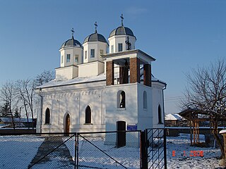
'Lesnovo' is a village in Central Western Bulgaria, part of Elin Pelin Municipality, Sofia Province. As of 2006 it has 1,829 inhabitants. The village came into existence in the 16-17th centuries. Lesnovo has a three-domed Eastern Orthodox church of 'St. Archangel Michael', a rare design in Bulgaria, dating back to the early 20th century; it also features pointed arches. Lesnovo Airport, a small newly-constructed private air strip, located on the South-Easterntern outskirts of the village has compromised the rural peace and quiet of this part of the countryside.

Beledie Han is a populated place in Kostinbrod Municipality, Sofia Province, in western Bulgaria, approximately 11 km northwest of the town of Kostinbrod.

Lesnovo may refer to:

Gabra, Sofia Province Place in Sofia

Gabra, is a village in Western Bulgaria, part of Elin Pelin Municipality, Sofia Province. The village is located in the valley between the mountains Sredna Gora and Lozenska Planina. There is а church, a primary school and chitalishte. Near-by the village there is a small orthodox monastery called Saint Demetrius. The original name of the village is Chukurovo. Since 1934 it is changed to Gabra. The name Gabra derives from the European Hornbeam.

Gorna Malina Place in Sofia, Bulgaria

Gorna Malina is a village in western Bulgaria, part of Sofia Province. It is the administrative centre of Gorna Malina municipality, which lies in the central eastern part of Sofia Province, 20-30 kilometres east of Sofia. The village is located between the western Balkan Mountains to the north and the Sredna Gora range to the south.

Bailovo village in Bulgaria

Bailovo is a village in Western Bulgaria, 43 km east of Sofia, Bulgaria. It is the home village of the Bulgarian writer Elin Pelin ., and ascetic Dobri Dobrev.

Elin Pelin Point

Elin Pelin Point is a point on the northwest coast of Smith Island, South Shetland Islands situated 4.6 km north-northeast of Cape James and 4.8 km south-southwest of Lista Point. Bulgarian early mapping in 2009. Named after the Bulgarian writer Elin Pelin.
Golema Rakovitsa Place in Sofia, Bulgaria

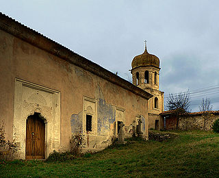
Golema Rakovitsa is a village in western Bulgaria, part of Elin Pelin Municipality, Sofia Province.

Lloyd Hill

Lloyd Hill is an ice-covered hill rising to 335 m in the southwest of Dryanovo Heights, Greenwich Island in the South Shetland Islands, Antarctica. The hill surmounts Teteven Glacier to the north and Murgash Glacier to the southeast.

Angel Granchov Bulgarian footballer

Angel Granchov is a Bulgarian footballer who plays as a defender for Kosovan club KF Flamurtari.

The Eleshnitsa monastery of the Assumption of the Virgin Mary is an active monastery, but currently there are no monks.

OFC Elin Pelin

OFC Elin Pelin is a Bulgarian football club based in the town of Elin Pelin, Sofia Province. It was founded in 1923 as Levski Elin Pelin.
References

  1. Koledarov, Nikolai Mitchev Pyotr. "Glossary of Settlements and Settlement Names, 1878-1987“, Sofia, 1989. (Bulgarian)

Coordinates: 42°44′33.4730″N23°37′31.3287″E / 42.742631389°N 23.625369083°E / 42.742631389; 23.625369083

Geographic coordinate system Coordinate system

A geographic coordinate system is a coordinate system that enables every location on Earth to be specified by a set of numbers, letters or symbols. The coordinates are often chosen such that one of the numbers represents a vertical position and two or three of the numbers represent a horizontal position; alternatively, a geographic position may be expressed in a combined three-dimensional Cartesian vector. A common choice of coordinates is latitude, longitude and elevation. To specify a location on a plane requires a map projection.