 |
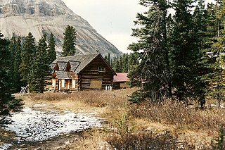
The Elizabeth Parker hut is an alpine hut located in Yoho National Park near Lake O'Hara in British Columbia. The hut is maintained by the Alpine Club of Canada. [1] [2]
| |
The Elizabeth Parker hut is an alpine hut located in Yoho National Park near Lake O'Hara in British Columbia. The hut is maintained by the Alpine Club of Canada. [1] [2]
The hut was named after the alpinist Elizabeth Parker, one of the founding members of the Alpine Club of Canada.The log cabin style structures were built in 1912 (Wiwaxy Cabin) and 1919 (main hut). [2]
The hut can be reached via Lake O'Hara Road, South off the Trans-Canada highway from a parking area.
Coordinates: 51°21′18″N116°20′36″W / 51.35500°N 116.34333°W NAD83 11U 545726 5689508
The hut sleeps about 24 in summer and 20 in winter. It is equipped with propane powered lamps, stovetop and oven.
The hut is used as a base for mountaineering and a starting point for trips to the Abbot Pass.

A mountain hut is a building located high in the mountains, generally accessible only by foot, intended to provide food and shelter to mountaineers, climbers and hikers. Mountain huts are usually operated by an Alpine Club or some organization dedicated to hiking or mountain recreation. They are known by many names, including alpine hut, mountain shelter, mountain refuge, mountain lodge, and mountain hostel. It may also be called a refuge hut, although these occur in lowland areas too.

The Tonquin Valley is located in Jasper National Park, Alberta, Canada, next to the border of the provinces of Alberta and British Columbia, an area which is also the continental divide, running along the peaks of the South Jasper Range which rise above Amethyst Lake. Tonquin Creek drains Moat Lake and flows west into Mount Robson Provincial Park in British Columbia, and empties into the Fraser River. The Astoria River drains south and east into the Athabasca River.
The Alpine Club of Canada (ACC) is an amateur athletic association with its national office in Canmore, Alberta that has been a focal point for Canadian mountaineering since its founding in 1906. The club was co-founded by Arthur Oliver Wheeler, who served as its first president, and Elizabeth Parker, a journalist for the Manitoba Free Press. Byron Harmon, whose 6500+ photographs of the Canadian Rockies in the early 20th century provide the best glimpse of the area at that time, was official photographer to the club at its founding. The club is the leading organization in Canada devoted to climbing, mountain culture, and issues related to alpine pursuits and ecology. It is also the Canadian regulatory organization for climbing competition, sanctioning local, regional and national events, and assembling, coaching and supporting the national team.

Abbot Pass lies between Mount Lefroy and Mount Victoria, in the divide between the valleys of Lake O'Hara and Lake Louise. It was named for Philip Stanley Abbot who died in 1896 in an attempt to climb Mount Lefroy with Charles Fay, Charles Thompson, and George T. Little.

The Waputik Icefield is located on the Continental divide in the Canadian Rocky Mountains, in the provinces of British Columbia and Alberta. It is developed on the heights of the Waputik Range in the Central Main Ranges.

Arthur Oliver Wheeler was born in Ireland and immigrated to Canada in 1876 at the age of 16. He became a land surveyor and surveyed large areas of western Canada, including photo-topographical surveys of the Selkirk Mountains and the British Columbia-Alberta boundary along the continental divide through the Canadian Rockies. In 1906, he and journalist Elizabeth Parker were the principal founders of the Alpine Club of Canada (ACC). He was its first president, from 1906 to 1910, and editor of the Canadian Alpine Journal from 1907 to 1930. He remained Honorary President of the ACC from 1926 until his death in 1945. The Arthur O. Wheeler hut of the ACC is named after him.
Elizabeth Parker was a Canadian journalist in the early 1900s. She attended school in Truro, Nova Scotia, obtained her teaching certificate, married Henry John Parker at the age of 18, moved to Halifax, Nova Scotia and then to Winnipeg, Manitoba. She co-founded the Alpine Club of Canada in 1906 with Arthur Oliver Wheeler.
The Stanley Mitchell hut is an alpine hut located at an altitude of 2,060 metres (6,759 ft) in the Little Yoho Valley in Yoho National Park, British Columbia, Canada. It sits in a small meadow not far from the base of a mountain called The President. It serves as a base for hiking, scrambling, ski-touring and climbing the nearby mountains. The hut is maintained by the Alpine Club of Canada.
The Elk Lakes cabin is an alpine hut located between the French and Italian Military Groups in the Canadian Rockies. It resides near the Continental Divide in Elk Lakes Provincial Park, British Columbia. It is 62 km south of the Trans-Canada Highway in Kananaskis Country, Alberta and 104 km north of Sparwood, British Columbia. The area has hiking trails, and provides access to mountaineering objectives. In winter, ice climbs and skiing terrain with much powder abound. Elk Lakes terrain is similar to that near the Elizabeth Parker hut. The hut is maintained by the Alpine Club of Canada.

The Arthur O. Wheeler hut is an alpine hut located four km southwest of Rogers Pass in Glacier National Park, British Columbia. Although not truly a backcountry hut, this log cabin is situated conveniently close to the Trans-Canada Highway in the Selkirk Mountains, west of the Rocky Mountains. It is often used as a base for mountaineering, hiking, and ski touring into the Asulkan Range and Illecillewaet Glacier areas south of the highway, and the Hermit Range north of the highway. The hut is maintained by the Alpine Club of Canada (ACC). It is the only ACC hut which can be reached by vehicle.
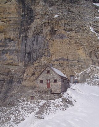
The Abbot Pass hut was an alpine hut located at an altitude of 2,925 metres (9,596 ft) in Abbot Pass in the Rocky Mountains in Alberta, Canada. It was nestled between Mount Victoria and Mount Lefroy, straddling the Great Divide, which, in this region, defines the boundary between Banff National Park in Alberta and Yoho National Park in British Columbia. While close to the border, the hut lay entirely in Banff National Park, and was the second-highest permanently habitable structure in Canada. The hut was maintained by the Alpine Club of Canada.

Lake O'Hara is a lake at an elevation of 2,020 metres (6,630 ft) in the alpine area of Yoho National Park, in the province of British Columbia, on the western side of the Great Divide with the province of Alberta and Banff National Park to the east. The lake and the valley are accessible through a bus service that is run by Parks Canada or by an 11 km hike along a road with an elevation gain of approximately 500m.
The Fay hut was an alpine hut located above Prospectors Valley in Kootenay National Park, British Columbia. Although the higher Neil Colgan hut superseded it as a base for climbs in the Valley of the Ten Peaks area, it still served as a convenient base for hikers and skiers doing day trips in the area, and as an overnight stop for mountaineers continuing on to the Neil Colgan hut. A new hut was built in 2005 to replace the original Fay hut, which was destroyed by a forest fire in 2003. The Fay hut was maintained by the Alpine Club of Canada (ACC).

The Bill Putnam hut is an alpine hut located in the Adamant Range of the Selkirk mountains in British Columbia. It is set on a knoll at the edge of a high mountain meadow and provides access to a great array of mountaineering objectives, but is best known for its spectacular skiing terrain. The hut is maintained by the Alpine Club of Canada.
The Skoki Ski Lodge National Historic Site of Canada was built in 1930-31 in the Skoki Valley of Canada's Banff National Park. Built by local members of the Ski Club of the Canadian Rockies, the lodge was the first commercial building built specifically to serve skiers in Canada, and possibly in North America. Design and construction work was carried out by local outfitter and builder Earl Spencer with help from Spud White and Victor Kutschera. The lodge was progressively expanded through 1936 by outfitter, guide and log home builder Jim Boyce who was also managing the Lodge the time. It has remained unaltered since that time. The Lodge operates throughout the year.

Lake Oesa is a body of water located at an elevation of 2,267 metres (7,438 ft) in the mountains of Yoho National Park, near Field, British Columbia, Canada, while a trail at the far end of the lake leads to Abbot Hut.

The Plain of Six Glaciers Tea House is situated on its namesake near Lake Louise, Alberta, Canada.
Opabin Lake is a body of water located at an elevation of 2,277 metres (7,470 ft) in the mountains of Yoho National Park, near Field, British Columbia, Canada.

Mount Biddle is a mountain in British Columbia, Canada.

Parker Ridge is a 2,255-metre (7,398-foot) mountain ridge located in the upper North Saskatchewan River valley in Banff National Park, in the Canadian Rockies of Alberta, Canada. Its nearest higher peak is Mount Athabasca, 7.7 km (4.8 mi) to the west. Parker Ridge is situated along the west side of the Icefields Parkway and southeast of Sunwapta Pass. Parker Ridge is a ski-touring destination in the winter and popular hiking destination in the summer because it is situated beside the Icefields Parkway allowing easy access, and is nearly entirely above treeline allowing good views of the surrounding mountain landscape. A 2.2 km (1.4 mi) trail gains 275 metres (900 ft) of elevation from the highway to the top of the ridge. Wandering east or west along the ridge provides views of Cirrus Mountain, the north face of Mount Saskatchewan, Saskatchewan Glacier, Mount Athabasca, Hilda Peak, and Nigel Peak among others.