Mount Lefroy

Last updated
Mount Lefroy
Mt. Lefroy, Banff.jpg
Mount Lefroy
Highest point
Elevation 3,423 m (11,230 ft) [1] [2]
Prominence 417 m (1,368 ft) [3]
Listing
Coordinates 51°21′44″N116°16′47″W / 51.36222°N 116.27972°W / 51.36222; -116.27972 [4]
Geography
Canada Alberta relief location map - transverse mercator proj.svg
Red triangle with thick white border.svg
Mount Lefroy
Location on Alberta/B.C. border
Canada British Columbia relief location map.jpg
Red triangle with thick white border.svg
Mount Lefroy
Mount Lefroy (British Columbia)
Country Canada
Provinces Alberta and British Columbia
Protected areas
Parent range Bow RangePark Ranges
Topo map NTS 82N8 Lake Louise [4]
Climbing
First ascent 1897 [3]
Easiest route West face (UIAA II) [1]

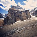
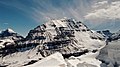
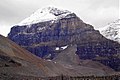
Mount Lefroy is a mountain on the Continental Divide, at the border of Alberta and British Columbia in western Canada. The mountain is located on the eastern side of Abbot Pass which separates Lake Louise in Banff National Park from Lake O'Hara in Yoho National Park. Mount Victoria lies immediately on the western side of the pass.

Contents

The mountain was named by George M. Dawson in 1894 for Sir John Henry Lefroy (1817–1890), an astronomer who had travelled over 8,800 kilometres (5,470 mi) in Canada's north between 1842 and 1844 making meteorological and magnetic observations. [1]

The mountain is the site of the first fatal accident in modern mountaineering in Canada. In 1896 during a failed summit bid, Philip Stanley Abbot slipped on rocks after just coming off an icy section and plummeted down the rock face to his death. [1]

The first successful ascent was made in 1897 by J. Norman Collie, Arthur Michael, H. Dixon; Charles Fay, Peter Sarbach, R. Vanderlip, C. Noyes, Charles Thompson, and H. Parker. [3]

A prominent painting by Canadian Group of 7 artist Lawren Harris, was painted at this site. [5]

Geology

Mount Lefroy is composed of sedimentary rock laid down during the Cambrian period. Formed in shallow seas, this sedimentary rock was pushed east and over the top of younger rock during the Laramide orogeny. [6]

Climate

Based on the Köppen climate classification, Mount Lefroy is located in a subarctic climate zone with cold, snowy winters, and mild summers. [7] Winter temperatures can drop below −20 °C with wind chill factors below −30 °C.

Related Research Articles

<span class="mw-page-title-main">Mount Peechee</span> Mountain in Canada

Mount Peechee is the third highest peak of the Fairholme Range in Banff National Park. Mt. Peechee is located immediately southeast of Mount Girouard in the Bow River valley south of Lake Minnewanka.

<span class="mw-page-title-main">Mount Saskatchewan (Alberta)</span> Mountain in Banff National Park, Alberta, Canada

Mount Saskatchewan is a mountain located in the North Saskatchewan River valley of Banff National Park, in the Canadian Rockies of Alberta, Canada.

<span class="mw-page-title-main">Mount Hector (Alberta)</span> Mountain in Banff National Park, Alberta, Canada

Mount Hector is a 3,394-metre (11,135-foot) mountain summit located in the Bow River valley of Banff National Park, in the Canadian Rockies of Alberta, Canada. The mountain was named in 1884 by George M. Dawson after James Hector, a geologist on the Palliser expedition. The mountain is located beside the Icefields Parkway, 17 km (11 mi) north of Lake Louise.

<span class="mw-page-title-main">Mount Babel (Alberta)</span> Mountain peak in Alberta, Canada

Mount Babel is a mountain peak of the Bow Range in Banff National Park, Alberta, Canada. The mountain can be seen from the Valley of the Ten Peaks.

<span class="mw-page-title-main">Mount Victoria (Bow Range)</span> Mountain in the country of Canada

Mount Victoria, 3,464 metres (11,365 ft), is a mountain on the border between British Columbia and Alberta in the Canadian Rockies. It is located just northeast of Lake O'Hara in Yoho National Park and is also part of Banff National Park and is on the Continental Divide. The mountain has two peaks, the south being the highest while the north peak is slightly lower at 3,388 metres (11,115 ft).

<span class="mw-page-title-main">Mount Ishbel</span> Mountain in Alberta, Canada

Mount Ishbel is a mountain peak in Banff National Park of Alberta, Canada. The peak is located in the Sawback Range in Alberta's Rockies, north of the Bow Valley Parkway and east of Johnston Canyon.

<span class="mw-page-title-main">Mount Patterson</span> Mountain in Banff NP, Alberta, Canada

Mount Patterson is a peak in the Waputik Range of the Canadian Rockies. It is located within Banff National Park in Alberta of Western Canada. Mount Patterson stands across the Mistaya River Valley from Mount Weed, and both are prominent features seen from the Icefields Parkway. Its nearest higher peak is Howse Peak, 10.14 km (6.30 mi) to the northwest.

<span class="mw-page-title-main">Mount Fay</span> Mountain in Banff NP, Alberta, Canada

Mount Fay is a mountain located on the border of Alberta and British Columbia on the Continental Divide in the Canadian Rockies. The mountain forms part of the backdrop to Moraine Lake in the Valley of the Ten Peaks of Banff National Park. It was named in 1902 by Charles E. Fay, an early explorer of the Canadian Rockies. He was a member of the party who attempted Mount Lefroy in 1896 when the first mountaineer to be killed in the Canadian Rockies occurred.

<span class="mw-page-title-main">Mount Aberdeen (Alberta)</span> Mountain in Alberta, Canada

Mount Aberdeen is a 3,152-metre (10,341-foot) mountain summit located in the Lake Louise area of Banff National Park, in the Canadian Rockies of Alberta, Canada. Its nearest higher peak is Mount Lefroy, 2.9 km (1.8 mi) to the southwest. Haddo Peak is on the same massif with Mount Aberdeen, and the Aberdeen Glacier is between the two peaks.

<span class="mw-page-title-main">Haddo Peak</span> Mountain peak in Banff NP, Canada

Haddo Peak is a summit in Alberta, Canada. Haddo Peak is located in the Lake Louise area of Banff National Park.

<span class="mw-page-title-main">Mount Wilson (Alberta)</span> Mountain in Banff National Park, Alberta, Canada

Mount Wilson is a 3,260-metre (10,696 ft) mountain summit located in the North Saskatchewan River valley of Banff National Park, in the Canadian Rockies of Alberta, Canada. Its nearest higher peak is Mount Cline, 9.81 km (6.10 mi) to the northeast. Mount Wilson is situated immediately north of the confluence of the North Saskatchewan River, Mistaya River, and Howse River near Saskatchewan Crossing, where the Icefields Parkway intersects with the David Thompson Highway.

<span class="mw-page-title-main">Mount Murchison (Alberta)</span> Mountain in Banff NP, Alberta, Canada

Mount Murchison is a 3,353-metre (11,001 ft) mountain summit located at the convergence of the North Saskatchewan River valley and Mistaya River valley of Banff National Park, in the Canadian Rockies of Alberta, Canada. The main summit has two high points: the Southeast Peak is 3,353 m, whereas the Northwest Peak is 3,333 m and separated by 700 m distance. Its nearest higher peak is Mount Cline, 15.71 km (9.76 mi) to the north. Mount Murchison is situated immediately southeast of the confluence of the North Saskatchewan River, Mistaya River, and Howse River near Saskatchewan Crossing, where the Icefields Parkway intersects with the David Thompson Highway.

<span class="mw-page-title-main">Mount Huber</span> Mountain in Canada

Mount Huber is a 3,348-metre (10,984-foot) summit located two kilometres east of Lake O'Hara in the Bow Range of Yoho National Park, in the Canadian Rockies of British Columbia, Canada. The nearest higher neighbor is Mount Victoria, 1.0 km (0.62 mi) to the north-northeast on the Continental Divide. Mount Huber is a secondary summit of Mount Victoria.

<span class="mw-page-title-main">Mount Smuts</span> Mountain in the country of Canada

Mount Smuts is a 2,938-metre (9,639-foot) mountain summit located in the Spray Valley, near the northern end of the Spray Mountains range. It is situated on the shared boundary of Peter Lougheed Provincial Park with Banff National Park in the Canadian Rockies of Alberta, Canada. Mount Smuts is not visible from any road in Banff Park, however, it can be seen from Alberta Highway 742, also known as Smith-Dorrien/Spray Trail in Kananaskis Country. Mount Smuts' nearest higher neighbor is Mount Birdwood, 2.8 km (1.7 mi) to the south-southeast.

<span class="mw-page-title-main">The Mitre (Alberta)</span> Mountain in Banff NP, Alberta, Canada

The Mitre is a 2,850-metre (9,350-foot) mountain summit located in the Lake Louise area of Banff National Park, in the Canadian Rockies of Alberta, Canada. Its nearest higher peak is Mount Lefroy, 1.0 km (0.62 mi) to the west. Mount Aberdeen is 2.0 km (1.2 mi) to the north-northeast, Lefroy Glacier immediately north, Mitre Glacier southwest, and Paradise Valley to the southeast.

<span class="mw-page-title-main">Mount Andromache</span> Mountain in Canada

Mount Andromache is a 3,033-metre (9,951-foot) mountain summit located in the Bow River valley of Banff National Park, in the Canadian Rockies of Alberta, Canada. The nearest higher neighbor is Mount Hector, 4.00 km (2.49 mi) to the south. Mount Andromache can be seen from the Icefields Parkway as the road traverses the western base of the peak. Topographic relief is significant as the summit rises 1,180 m (3,870 ft) above the parkway in 1.5 km (0.93 mi). The Molar Glacier is situated on the northeast aspect of the mountain. Precipitation runoff from Mount Andromache drains into tributaries of the Bow River.

<span class="mw-page-title-main">White Pyramid (Banff)</span> Mountain in Banff NP, Alberta, Canada

White Pyramid is a 3,219-metre (10,561 ft) mountain summit located between the Howse River valley and Mistaya River valley of Banff National Park, in the Canadian Rockies of Alberta, Canada. Its nearest higher peak is Howse Peak, 3.00 km (1.86 mi) to the south. Topographic relief is significant as the summit rises 1,460 meters (4,790 ft) above Chephren Lake in 2.5 km. White Pyramid is visible from the Icefields Parkway in the vicinity of Waterfowl Lakes.

<span class="mw-page-title-main">Mount Outram</span> Mountain in Banff NP, Alberta, Canada

Mount Outram is a 3,245-metre (10,646-foot) mountain summit located in the Howse River Valley of Banff National Park, in the Canadian Rockies of Alberta, Canada. Its nearest higher peak is Mount Forbes, 4.37 km (2.72 mi) to the southwest. Glacier Lake is situated 4.0 km (2.5 mi) to the north, and the Sir James Glacier lies below the south aspect of the peak. Mount Outram can be seen from the Icefields Parkway southwest of Saskatchewan Crossing, with optimum photography conditions in morning light.

<span class="mw-page-title-main">Hilda Peak</span> Mountain peak in Banff NP, Alberta, Canada

Hilda Peak is a 3,058-metre (10,033-foot) mountain summit located at the northern extreme of Banff National Park in the Canadian Rockies of Alberta, Canada. The nearest higher peak is Mount Athabasca, 2.0 km (1.2 mi) to the southwest. Hilda Peak is situated south of Sunwapta Pass and can be prominently seen from the Icefields Parkway. The Hilda Glacier lies to the south side of the peak, and the Boundary Glacier lies to the west.

<span class="mw-page-title-main">Mount Noyes</span> Mountain in Banff NP, Alberta, Canada

Mount Noyes is a 3,080-metre (10,100-foot) mountain summit located in the Mistaya River valley of Banff National Park, in the Canadian Rockies of Alberta, Canada. Mount Noyes is situated at the confluence of Silverhorn Creek and Mistaya River, 3.5 km northwest of Mount Weed, and 9.2 km east of Howse Peak. Its nearest higher peak is Mount Patterson, 8.55 km (5.31 mi) to the south. Topographic relief is significant as it rises over 1,380 metres above the Icefields Parkway in two km.

References

  1. 1 2 3 4 "Mount Lefroy". cdnrockiesdatabases.ca. Retrieved 2019-08-17.
  2. "Topographic map of Mount Lefroy". opentopomap.org. Retrieved 2023-07-23.
  3. 1 2 3 "Mount Lefroy". Bivouac.com. Retrieved 2008-10-05.
  4. 1 2 "Mount Lefroy". BC Geographical Names . Retrieved 2012-08-08.
  5. "Lawren S. Harris, Mt. Lefroy, 1930". Art!Facts. McMichael Canadian Art Collection. 2006. Archived from the original on 2013-01-15. Retrieved 2010-08-11.
  6. Gadd, Ben (2008). Geology of the Rocky Mountains and Columbias.
  7. Peel, M. C.; Finlayson, B. L.; McMahon, T. A. (2007). "Updated world map of the Köppen−Geiger climate classification". Hydrol. Earth Syst. Sci. 11: 1633–1644. ISSN   1027-5606.