
Onehunga is a suburb of Auckland in New Zealand and the location of the Port of Onehunga, the city's small port on the Manukau Harbour. It is eight kilometres south of the city centre, close to the volcanic cone of Maungakiekie / One Tree Hill.
Ellerslie is a suburb of the city of Auckland, in the North Island of New Zealand. Ellerslie lies seven kilometres to the southeast of the city centre, close to State Highway 1.

Te Papapa is a suburb of Auckland, New Zealand. It is located nine kilometres to the southeast of Auckland city centre, on the northern shore of Mangere Inlet, an arm of the Manukau Harbour. The residential and light-industrial suburb lies between the suburbs of Onehunga, Penrose, and Southdown, and is at the northern end of the Māngere Bridge which connects it with the South Auckland suburb of Māngere. Train services on the Onehunga Line run through the suburb on the Onehunga Branch line, which reopened in 2010. Services at Te Papapa station commenced on 19 September 2010. Carter Holt Harvey's head office is located at 173 Captain Springs Road in the Te Papapa area. It has been suggested that the name of the suburb refers to a fortress built of rock slabs. However, at the time Te Papapa Railway Station first opened the area around was commonly known as "Pumpkin Flat" and a short article in the Auckland Star reported that the general manager of the railways had chosen to name the station after the "Maori long pumpkin or Te Papapa" in remembrance of the commonly used name.

Britomart Transport Centre is the public transport hub in the central business district of Auckland, New Zealand, and the northern terminus of the North Island Main Trunk railway line. It combines a railway station in a former Edwardian post office, extended with expansive modernist architectural elements, with a bus interchange. It is at the foot of Queen Street, the main commercial thoroughfare of Auckland city centre, with the main ferry terminal just across Quay Street.

Swanson railway station is a station on the North Auckland Line in Auckland, New Zealand.

Avondale railway station is on the Western Line of the Auckland railway network. Relocated in 2008, the station can be accessed from St Jude St, Layard St, and Crayford St.
Baldwin Avenue railway station, in the suburb of Mount Albert, is on the Western Line of the Auckland railway network. The station has offset side platforms connected by a level crossing.

Newmarket railway station is a station in the inner-city suburb of Newmarket in Auckland, New Zealand. It serves the Southern, Onehunga and Western Lines of the Auckland railway network, and is the second-busiest station in Auckland, after Britomart.

Greenlane railway station serves the Southern Line and Onehunga Line of the Auckland railway network. It was opened circa 1877. It has an island platform and is reached via a ramp from Green Lane East. It is the nearest station to Ellerslie Racecourse, Greenlane Clinical Centre, ASB Showgrounds and Cornwall Park.

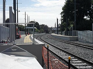
Ellerslie railway station serves the Southern and Onehunga Lines of the Auckland railway network in New Zealand. It was opened in 1873. It has an island platform and is 1.37 km (0.85 mi) south of Greenlane and 1.45 km (0.90 mi) north of Penrose.

Penrose railway station is a station at Penrose, Auckland, on the Southern Line of the Auckland railway network, New Zealand. It has an island platform and is reached by pedestrian over bridges from Great South Road and Station Road. It still has its original wooden station building on the platform.
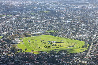
Ellerslie Racecourse is the main racecourse in Auckland, New Zealand, for thoroughbred racehorses. It is an undulating, grass circuit in the suburb of Ellerslie, with a circumference of just under 1,900 metres. Racing is conducted in a clockwise (right-handed) direction.

Greenlane is a central isthmus suburb in Auckland, New Zealand. It is bounded by Epsom to the west, Newmarket to the north, Remuera to the east and One Tree Hill to the south.

The Onehunga Branch railway line is a section of the Onehunga Line in Auckland, New Zealand. It was constructed by the Auckland Provincial Government and opened from Penrose to Onehunga on 24 December 1873, and extended to Onehunga Wharf on 28 November 1878. It is 3.6 kilometres (2.2 mi) in length and is single-track only.

Auckland railway electrification occurred in phases as part of investment in a new infrastructure for Auckland's urban railway network. Electrification of the network had been proposed for several decades. Installation started in the late 2000s after funds were approved from a combination of regional and central government budgets.

Parnell railway station is a station serving the inner-city suburb of Parnell in Auckland, New Zealand. It is situated on the Newmarket Line, approximately 600m north of Parnell Tunnel, and is located in the Waipapa Valley adjacent to Auckland Domain. It serves Southern Line and Western Line trains. Onehunga Line trains currently pass through the station without stopping.

Te Papapa railway station is on the Onehunga Branch section of the Onehunga Line, one of the lines of the Auckland railway network in New Zealand. It has a side platform layout and is reached from Mays Rd.
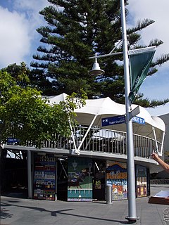
Onehunga railway station is the final station on the Onehunga Line of the Auckland railway network in New Zealand. It is located at the southern end of Onehunga Town Centre and consists of a single side platform which is accessed from Onehunga Mall and Princes Street.
The Bundamba Racecourse railway station is located in Booval, City of Ipswich, Queensland, Australia. It is on the Redbank - Bundamba Loop line which extends to the Swanbank Power Station in Swanbank.

Onehunga Wharf railway station on the Onehunga Branch section of the Onehunga Line was the terminal station for the line to Auckland in the 19th and early 20th century.
