
Shropshire is a ceremonial county in the West Midlands of England, on the border with Wales. It is bordered by Cheshire to the north-east, Staffordshire to the east, Worcestershire to the south-east, Herefordshire to the south, and the Welsh principal areas of Powys and Wrexham to the west and north-west respectively. The largest settlement is Telford, while Shrewsbury is the county town.
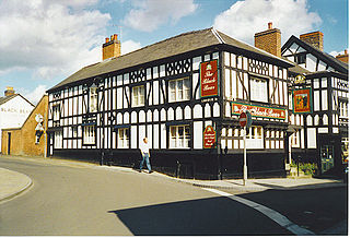
Whitchurch is a market town in the civil parish of Whitchurch Urban, in the north of Shropshire, England. It lies 2 miles (3 km) east of the Welsh border, 2 miles south of the Cheshire border, 20 miles (30 km) north of the county town of Shrewsbury, 20 miles (30 km) south of Chester, and 15 miles (24 km) east of Wrexham. At the 2021 Census, the population of the parish was 10,141. Whitchurch is the oldest continuously inhabited town in Shropshire. Notable people who have lived in Whitchurch include the composer Sir Edward German, and illustrator Randolph Caldecott.

Ellesmere is a town in the civil parish of Ellesmere Urban, in Shropshire, England; it is located near to the Welsh border, the towns of Oswestry and Whitchurch, and the Welsh city of Wrexham. It is notable for its proximity to a number of prominent meres.
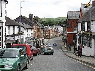
Knighton is a market town and community on the River Teme, straddling the border between Powys, Wales and Shropshire, England. It lies in the traditional county of Radnorshire. Originally an Anglo-Saxon settlement, Knighton is located on Offa's Dyke, the ancient earthwork that divided the two countries. It later became a Norman defensive border town.
Mold is a town and community in Flintshire, Wales, on the River Alyn. It is the county town and administrative seat of Flintshire County Council, as it was of Clwyd from 1974 to 1996. According to the 2011 UK census, it had a population of 10,058. A 2019 estimate puts it at 10,123.

Sycharth was a motte and bailey castle near Llansilin, Powys, Wales. Until 1996 Sycharth was in the historic county of Denbighshire, but was then transferred to the Shire area of Montgomeryshire within Powys. Sycharth was the birthplace of Owain Glyndŵr.
Castle Toot, or Cleobury Castle, was a motte castle by the River Rea in the town of Cleobury Mortimer, Shropshire. It is a scheduled monument, first listed in 1951.

Hopton Castle is situated in the village of the same name which lies approximately halfway between Knighton and Craven Arms, in the English county of Shropshire. Hopton Castle featured in the TV series Time Team in 2010. A ruin since the early 18th century, it was partially restored between 2006 and 2011, and was officially re-opened to the public as a visitor attraction in December 2011 by the Duke of Gloucester.

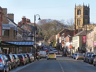
Shrewsbury is a market town and civil parish in Shropshire, England. It is sited on the River Severn, 33 miles (53 km) northwest of Wolverhampton, 15 miles (24 km) west of Telford, 31 miles (50 km) southeast of Wrexham and 53 miles (85 km) north of Hereford. At the 2021 census, the parish had a population of 76,782. It is the county town of the ceremonial county of Shropshire.

The Poso is a river of Central Sulawesi on Sulawesi island, Indonesia, about 1600 km northeast of the capital Jakarta. The Poso is approximately 100 km long and flows from Lake Poso, about 2 km west of the town of Tentena to the city of Poso and then into the Gulf of Tomini.

The Siak is a river of Riau province, in the east of Sumatra, Indonesia, about 1000 km northwest of the capital Jakarta. Approximately 370 kilometres in length, the Siak is a blackwater river which owes its brown color to dissolved organic matter (DOM) leached from surrounding, heavily disturbed peat soils; it is heavily polluted, notably by the petroleum industry. It flows through the town of Pekanbaru before emptying into the Strait of Malacca.

Melawi River is a river in north-western Borneo, Indonesia, about 900 km northeast of the capital Jakarta. It is a tributary of the Kapuas River.
The Bahau River is a river in North Kalimantan, Indonesia, about 1400 km northeast of the capital Jakarta.
Tamiang River is a river in the province of Aceh, northern Sumatra, Indonesia,
Silau River is a river in northern Sumatra, Indonesia, about 1300 km northwest of the capital Jakarta. It is a tributary of Asahan River.
The Bila River is a river in northern Sumatra, Indonesia, about 1,200 km northwest of the capital Jakarta. It is a tributary of the Barumun River.

Rokan River is a river in Riau province, central-eastern Sumatra, Indonesia, about 1,100 km northwest of the capital Jakarta.

Oswestry Castle is a medieval castle in the town of Oswestry, Shropshire, England. The castle has also been known as, or recorded in historical documents as: Album Monasterium; Blancminster; Blankmouster; Blancmustier; Croes Oswald; L'Oeuvre; L'uvre; Castle Loure; Luure; Luvre; Lvvre: Castle Philip; Oswaldestre; Meresberie.
Wonominta, New South Wales is a remote rural locality and civil parish of Evelyn County in far northwest New South Wales. located at 30°18′40″S 141°05′05″E.
Peusangan River is a river in Sumatra, in the western part of Indonesia, about 1,700 km northwest of the capital Jakarta.
