The Yuba-Sutter Gold Sox are a summer collegiate wood-bat baseball club based in Marysville, California, in the United States, that began as an independent professional team in 1995. They play their home games at Hard Rock Park, formerly known as Bryant Field, adjacent to Ellis Lake, in Marysville. The team name was changed to the Marysville Gold Sox in 2010 to more particularly identify the city in which the team is located, but have since reverted to "Yuba-Sutter".
Marysville is a city and the county seat of Yuba County, California, located in the Gold Country region of Northern California. As of the 2010 United States Census, the population was 12,072, reflecting a decrease of 196 from the 12,268 counted in the 2000 Census. It is part of the Yuba-Sutter area of Greater Sacramento.
Marysville is a city in St. Clair County of the U.S. state of Michigan. The population was 9,959 at the 2010 census. The municipality was founded in 1919, first as a village, then became a city in 1924.

Marysville is a city in Snohomish County, Washington, United States, part of the Seattle metropolitan area. The city is located 35 miles (56 km) north of Seattle, adjacent to Everett on the north side of the Snohomish River delta. It is the second-largest city in Snohomish County after Everett, with a population of 60,020 in the 2010 U.S. census. As of 2015, Marysville was also the fastest-growing city in Washington state, growing at an annual rate of 2.5 percent.
Gilbert Stanley Underwood (1890–1960) was an American architect best known for his National Park lodges. Born in 1890, Underwood received his B.A. from Yale in 1920 and a M.A. from Harvard in 1923. After opening an office in Los Angeles that year, he became associated with Daniel Ray Hull, a landscape architect, of the National Park Service. This led to a commission with the Utah Parks Company of the Union Pacific Railroad which was developing the parks in hopes of producing destinations for travelers. During this time Underwood designed lodges for Cedar Breaks National Monument, Zion National Park, Bryce Canyon National Park, and the North Rim of the Grand Canyon National Park. His surviving Utah Parks Company buildings are considered exceptional examples of the Rustic style of architecture, and are all listed on the National Register of Historic Places. In addition, Underwood was contracted to design Yosemite National Park's The Ahwahnee, also on the National Register and probably his greatest triumph in the Rustic style.

State Route 20 is a state highway in the northern-central region of the state of California, running east–west north of Sacramento from the North Coast to the Sierra Nevada. Its west end is at SR 1 in Fort Bragg, from where it heads east past Clear Lake, Colusa, Yuba City, Marysville and Nevada City to I-80 near Emigrant Gap, where eastbound traffic can continue on other routes to Lake Tahoe or Nevada.

State Route 70 is a state highway in the U.S. state of California, connecting SR 99 north of Sacramento with U.S. Route 395 near Beckwourth Pass via the Feather River Canyon. Through the Feather River Canyon, from SR 149 to US 395, SR 70 is the Feather River Scenic Byway, a Forest Service Byway that parallels the ex-Western Pacific Railroad's Feather River Route.

The Sacramento Northern Railway was a 183-mile (295 km) electric interurban railway that connected Chico in northern California with Oakland via the California capital, Sacramento. In its operation it ran directly on the streets of Oakland, Sacramento, Yuba City, Chico, and Woodland and ran interurban passenger service until 1941 and freight service into the 1960s.

The Overland Telegraph Company was one of the organizations responsible for constructing the telegraph line which resulted in the first transcontinental telegraph network in the United States. The company built the section of line between Fort Churchill, Nevada Territory and Salt Lake City, Utah Territory.
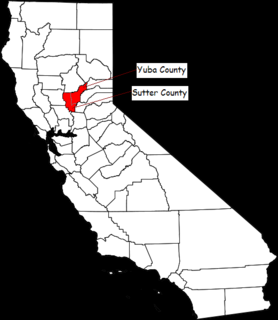
The Yuba–Sutter area, or Yuba City Metropolitan Statistical Area, is a smaller metropolitan community including Yuba and Sutter Counties in Northern California's Central Valley within the Greater Sacramento area.
State Route 204 (SR 204) is a short state highway in Snohomish County, Washington, United States. It connects U.S. Route 2 (US 2) at the eastern end of the Hewitt Avenue Trestle to the city of Lake Stevens, terminating at a junction with SR 9. The highway runs for a total length of 2.4 miles (3.9 km) and passes through several suburban neighborhoods.
State Route 531 (SR 531) is a short state highway in Snohomish County, Washington, United States. It runs from west to east along 172nd Street between Wenberg County Park on Lake Goodwin to a junction with SR 9 in southern Arlington, with an intermediate interchange with Interstate 5 (I-5) in Smokey Point. The highway is the primary access point for the Arlington Municipal Airport and the Smokey Point retail corridor.

State Route 528 (SR 528) is a state highway in Snohomish County, Washington, located entirely within the city of Marysville. It spans 3.5 miles (5.6 km) from an interchange with Interstate 5 (I-5) in downtown Marysville to a junction with SR 9. The highway primarily functions as a commuter route and uses two local streets: 4th Street and 64th Street.
Charles Eamer Sexey was an English trader. He first visited New Zealand as a young man where he farmed and traded. In 1849 he travelled to San Francisco and took part in the Gold Rush as a trader in the mining camps. Eventually, having made his fortune out of the mining industry, he moved to Marysville, California, where he became a Levee Commissioner, landowner and President of the informal anti-mining activist group, the Anti-Debris Association, which was concerned with protecting landowner rights. He built some of the most important buildings in the city, one of which housed the Appeal newspaper, now known as the Appeal-Democrat.
State Route 92 (SR 92) is a short state highway entirely within Snohomish County, Washington, United States. The nine-mile (14.5 km) highway connects SR 9 in Lake Stevens to the Mountain Loop Highway in Granite Falls.

Arboga is an unincorporated community in Yuba County, California. It is located 3 miles (4.8 km), south of Olivehurst on the Sacramento Northern Railroad, at an elevation of 56 feet. It was named in 1911 by the pastor of the Mission Covenant Church of Sweden for his hometown of Arboga, Sweden.
This article lists the railroads and a timeline of railroad history in Solano County, California.
Ellis Lake is a man-made lake in Marysville, California.

The Yuba City Bears were a summer collegiate wood-bat club based in Marysville, California, in the United States and representing Yuba City, California. They were a member of the Great West League, having been established in 2017, and had played their home games at Colusa Casino Stadium adjacent to Ellis Lake, in Marysville. They had shared the facilities with the Yuba-Sutter Gold Sox, but have since folded their GWL operations.
The California State Telegraph Company was a business originally organized to provide telegraph service between San Francisco and Marysville, California. By the spring of 1861, the company had expanded its service area south to Los Angeles, north to Yreka, and east to Fort Churchill by absorbing the other telegraph companies in California. In 1861, the company formed the Overland Telegraph Company, which was responsible for constructing part of the telegraph line which resulted in the first transcontinental telegraph network in the United States.


