
Lake of the Woods County is a county in the U.S. state of Minnesota. As of the 2010 United States Census, the population was 4,045, making it the second-least populous county in Minnesota. Its county seat is Baudette.

Farm Island Township is a township in Aitkin County, Minnesota, United States. The population was 1,099 as of the 2010 census.

Nordland Township is a township in Aitkin County, Minnesota, United States. The population was 972 as of the 2010 census.
Elmer Township is a township in Saint Louis County, Minnesota, United States. The population was 151 at the 2010 census.

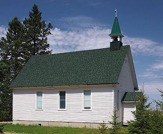
The Northwest Angle, known simply as the Angle by locals, and coextensive with Angle Township, is a part of northern Lake of the Woods County, Minnesota. Except for minor surveying errors, it is the only place in the contiguous United States north of the 49th parallel, which forms the border between the U.S. and Canada from the Northwest Angle westward to the Strait of Georgia. The land area of the Angle is separated from the rest of Minnesota by Lake of the Woods, but shares a land border with Canada. It is one of only six non-island locations in the 48 contiguous states that are practical exclaves of the U.S. It is the northernmost township in Minnesota and contains the northernmost point in the contiguous 48 states. The unincorporated community of Angle Inlet is in the Northwest Angle.

The Crow Wing River is a 113-mile-long (182 km) tributary of the Mississippi River in Minnesota, United States. The river rises at an elevation of about 1391 feet in a chain of 11 lakes in southern Hubbard County, Minnesota, and flows generally south, then east, entering the Mississippi at Crow Wing State Park northwest of Little Falls, Minnesota. Its name is a loose translation from the Ojibwe language Gaagaagiwigwani-ziibi. A wing-shaped island at its mouth accounts for the river's name. Because of its many campsites and its undeveloped shores, the Crow Wing River is considered one of the state's best "wilderness" routes for canoeists; although it is shallow, it is nearly always deep enough for canoeing.
Myre-Big Island State Park is a state park of Minnesota, USA, just outside the city of Albert Lea. It has an area of 1,578 acres (6.39 km2). The park protects 8 miles (13 km) of shoreline on Albert Lea Lake. The nucleus of the park is Big Island, a 117-acre (0.47 km2) island attached to the mainland by a causeway. In turn a causeway connects Big Island to Little Island. The park was formerly named Helmer Myre State Park after former Minnesota State Senator Helmer Myre.
Sakatah Lake State Park is an 842-acre (341 ha) state park of Minnesota, USA, on a natural widening of the Cannon River near the town of Waterville. The Dakota native to the area called it "Sakatah" which means "singing hills". To honor this native heritage, some of the trails in the park have been given Dakota names. The Sakatah Singing Hills State Trail, which connects Faribault and Mankato, runs through this park.

Lake Shetek State Park is a state park of Minnesota, United States, on Lake Shetek, which is the largest lake in southwestern Minnesota and the headwaters of the Des Moines River. It is most popular for water recreation and camping. However the park also contains historical resources related to the Dakota War of 1862, including an original log cabin and a monument to 15 white settlers killed there and at nearby Slaughter Slough on August 20, 1862.
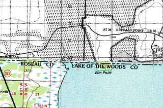
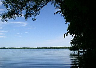
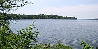
Elm Point, Minnesota, in Lake of the Woods County, Minnesota, is a small uninhabited cape and a United States practical exclave, southwest of the Northwest Angle, near the Indian/First Nation community of Buffalo Point. It borders Canada's province of Manitoba at the 49th parallel and is separated from the rest of the continental United States by Lake of the Woods.

The Siberian Elm cultivar Ulmus pumila 'Hansen' is a little-known American tree of obscure origin, possibly raised from seed collected by the horticulturist and botanist Prof. Niels Hansen during his expedition to Siberia in 1897.
Markham is an unincorporated community in Colvin Township, Saint Louis County, Minnesota, United States.
Elmer is an unincorporated community in Elmer Township, Saint Louis County, Minnesota, United States. The community is located near Meadowlands at the intersection of County Road 199 and County Road 193.

The Cedar River is a 38.5-mile-long (62.0 km) river in the central Adirondacks, in Hamilton County, New York. It rises at the outlet of Cedar Lake in the Town of Arietta and flows northeast into the Town of Lake Pleasant, where it passes through the Cedar River Flow. Continuing northeast and east, it passes through the Town of Indian Lake and remote corners of the Towns of Minerva and Newcomb to join the Hudson River northeast of the hamlet of Indian Lake. The Northville-Placid Trail goes past the Cedar Lakes and along the Cedar River to the flow.
The Lake of the Woods State Forest is a state forest located south of Lake of the Woods in Beltrami, Koochiching, Lake of the Woods, and Roseau counties, Minnesota. The forest borders the Pine Island State Forest to the east and the Beltrami Island State Forest to the west.

The Northwest Angle State Forest is a state forest located in Lake of the Woods County, Minnesota. The name of the forest is derived from its location near the Northwest Angle, the northernmost point of the contiguous United States. The forest borders the Canadian provinces of Manitoba and Ontario, and the Red Lake Indian Reservation. The forest is managed by the Minnesota Department of Natural Resources.

Greenleaf Lake State Recreation Area is a state park unit of Minnesota, USA, currently in development. It includes undeveloped shoreline on both Greenleaf and Sioux Lakes, halfway between the cities of Hutchinson and Litchfield in Meeker County. Portions of the state recreation area (SRA) are open to the public for day-use recreation, but there are no facilities yet on site. The park boundaries were set by the Minnesota Legislature and the state is still acquiring land from willing sellers; two-thirds of the property remain privately owned.
East Lake is an unincorporated community in Spalding Township, Aitkin County, Minnesota, United States.
Island Lake is an unincorporated community in Beltrami County, in the U.S. state of Minnesota.
The Rum River State Forest is a state forest located in Kanabec, Mille Lacs and Morrison counties in central Minnesota. The forest is nearby the city of Onamia and is along the Rum River, just downstream (south) of Mille Lacs Lake. The forest is managed by the Minnesota Department of Natural Resources. The forest is home to many Northern hardwoods such as maple, oak, ash, elm and basswood that occupy most of the upland areas while tamarack and black spruce are found in lowland and marshy areas.
