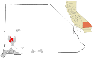
San Bernardino County, officially the County of San Bernardino, is a county located in the southern portion of the U.S. state of California, and is located within the Inland Empire area. As of the 2020 U.S. Census, the population was 2,181,654, making it the fifth-most populous county in California and the 14th-most populous in the United States. The county seat is San Bernardino.

Victorville is a city in Victor Valley in San Bernardino County, California. Its population as of the 2020 census was 134,810.

A roadside attraction is a feature along the side of a road meant to attract tourists. In general, these are places one might stop on the way to somewhere, rather than being a destination. They are frequently advertised with billboards. The modern tourist-oriented highway attraction originated as a U.S. and Canadian phenomenon in the 1940s to 1960s, and subsequently caught on in Australia.

Santa Claus is an uninhabited desert place in Mohave County, Arizona, United States. Originating in 1937, Santa Claus lies approximately 14 miles (23 km) northwest of Kingman, Arizona, along U.S. Route 93 between mile markers 57 and 58, immediately north of Hermit Drive and just south of both Grasshopper Junction, Arizona, and the Junk Art of Chloride, a group of metal statues in Chloride, Arizona, that include a flamingo made out of a motorcycle gas tank. Characterized in 1988 as "a little roadside place on the west shoulder of U.S. Route 93," Santa Claus receives traffic from motorists driving between Phoenix, Arizona, and Las Vegas, Nevada, or Hoover Dam.
Nut Tree is a mixed-use development in Vacaville, California near the intersection of Interstate 80 and Interstate 505.
Oro Grande is an unincorporated community in the Mojave Desert of San Bernardino County, California, United States. It lies on the city boundary of Victorville and Adelanto. It is at 3,000 feet (910 m) elevation in Victor Valley north of the San Bernardino mountain range. It is located on old Route 66 near Interstate 15 between Victorville and Barstow. The ZIP code is 92368 and the community is inside area codes 442 and 760. Less than 1,000 residents live in the unincorporated area.

Helendale or Silver Lakes is an unincorporated community and census-designated place located in the Victor Valley of the Mojave Desert, within San Bernardino County, California.

U.S. Route 66 is a part of a former United States Numbered Highway in the state of California that ran from the west in Santa Monica on the Pacific Ocean through Los Angeles and San Bernardino to Needles at the Arizona state line. It was truncated during the 1964 renumbering and its signage removed in 1974. The highway is now mostly replaced with several streets in Los Angeles, State Route 2 (SR 2), SR 110, SR 66, San Bernardino County Route 66 (CR 66), Interstate 15 (I-15), and I-40.

Santa Nella is an unincorporated village and census-designated place (CDP) in Merced County, California, United States. It is located 10 miles (16 km) west-northwest of Los Banos at an elevation of 154 feet (47 m). As of the 2020 census, Santa Nella had a population of 2,211, up from 1,380 at the 2010 census.

State Highway 118 is a 155.3-mile (249.9 km) state highway in the U.S. state of Texas that runs from Big Bend National Park north to Kent and passes through the towns of Study Butte, Alpine, and Fort Davis. SH 118 is maintained by the Texas Department of Transportation (TxDOT). The road lies entirely within the Trans-Pecos region of Texas. SH 118 is a two-lane road along its length except for a section in Alpine where the route follows the path of U.S. Route 67 and U.S. Route 90. All of the route except for the 2.8-mile (4.5 km) section between Big Bend National Park and Farm to Market Road 170 is included in the Texas Historical Commission's Texas Mountain Trail.

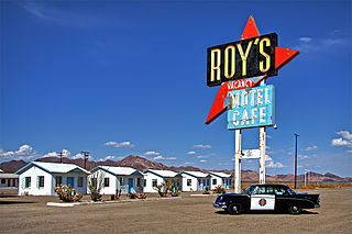
Roy's Motel and Café is a motel, café, gas station and auto repair shop on the National Trails Highway, the former U.S. Route 66, in the Mojave Desert town of Amboy in San Bernardino County, California. It has been defunct for years, but is now being restored. The historic site is an example of roadside Mid-Century Modern Googie architecture. The entire town of Amboy—including the Roy's complex—is owned by and under the stewardship of a private preservationist.

Oak Glen is a census-designated place situated between the San Bernardino Mountains and the Little San Bernardino Mountains in San Bernardino County, California, United States. Oak Glen is located 15 miles east of San Bernardino, at an elevation of 4,734 feet (1,443 m). The population was 638 at the 2010 census.
Hula Ville, also known as Hulaville Forest and Mahan's Half Acre, was a 0.5 acres (0.20 ha) folk art environment of outdoor sculptures, and a roadside attraction of the Victor Valley area, in the Mojave Desert. It was formerly near the town of Hesperia in San Bernardino County, Southern California.

Lajitas is an unincorporated community in Brewster County, Texas, United States, near the Big Bend National Park. According to the Handbook of Texas, the community had a population of 75 in 2010.
The Oro Grande School district is located in the town of Oro Grande, California.

Pops restaurant in Arcadia, Oklahoma is a modern roadside attraction on Route 66. Using a theme of soda pop, it is marked by a giant neon sign in the shape of a soda pop bottle. The glass walls of the restaurant are decorated with shelves of soda pop bottles, arranged by beverage color. These bottles are for sale as-is, or may be purchased cold from the huge refrigerator at the western end.

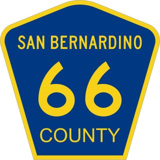
County Route 66 is an east–west numbered road in San Bernardino County, California, United States. It runs for 175.7 miles (282.8 km) from Oro Grande to the U.S. Route 95 (US 95) at Arrowhead Junction. The entire route is part of the former U.S. Route 66 (US 66), connecting towns that were bypassed by Interstate 40 (I-40) such as Oro Grande and Amboy. It is the only numbered county route in San Bernardino County.
Bryman, is a populated place in the central Mojave Desert, within San Bernardino County, California. It lies along the Mojave River in the northern Victor Valley, at an elevation of 2,526 feet . It is on the historic U.S. Route 66, 5 miles north of Oro Grande, and south of Helendale.
John Samuel Margolies was an architectural critic, photographer, and author who was noted for celebrating vernacular and novelty architecture in the United States, particularly those designed as roadside attractions. Starting from the mid-1970s, he began to photograph sites during long road trips, since he was concerned these sites would be displaced by the growing modernist trend. He was credited with shaping postmodern architecture and recognizing buildings that would be added to the National Register of Historic Places through his documentary work. Starting in 2007, the Library of Congress began to acquire his photographs, and created the public domain John Margolies Roadside America Photograph Archive in 2016, consisting of 11,710 scans of color slides taken by Margolies.


