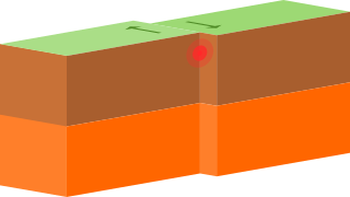
A transform fault or transform boundary, is a fault along a plate boundary where the motion is predominantly horizontal. It ends abruptly where it connects to another plate boundary, either another transform, a spreading ridge, or a subduction zone. A transform fault is a special case of a strike-slip fault that also forms a plate boundary.

In plate tectonics, a divergent boundary or divergent plate boundary is a linear feature that exists between two tectonic plates that are moving away from each other. Divergent boundaries within continents initially produce rifts, which eventually become rift valleys. Most active divergent plate boundaries occur between oceanic plates and exist as mid-oceanic ridges.

The North American plate is a tectonic plate containing most of North America, Cuba, the Bahamas, extreme northeastern Asia, and parts of Iceland and the Azores. With an area of 76 million km2 (29 million sq mi), it is the Earth's second largest tectonic plate, behind the Pacific plate.

The Explorer plate is an oceanic tectonic plate beneath the Pacific Ocean off the west coast of Vancouver Island, Canada, which is partially subducted under the North American plate. Along with the Juan de Fuca plate and Gorda plate, the Explorer plate is a remnant of the ancient Farallon plate, which has been subducted under the North American plate. The Explorer plate separated from the Juan de Fuca plate roughly 4 million years ago. In its smoother, southern half, the average depth of the Explorer plate is roughly 2,400 metres (7,900 ft) and rises up in its northern half to a highly variable basin between 1,400 metres (4,600 ft) and 2,200 metres (7,200 ft) in depth.

The Australian plate is a major tectonic plate in the eastern and, largely, southern hemispheres. Originally a part of the ancient continent of Gondwana, Australia remained connected to India and Antarctica until approximately 100 million years ago when India broke away and began moving north. Australia and Antarctica had begun rifting by 96 million years ago and completely separated a while after this, some believing as recently as 45 million years ago, but most accepting presently that this had occurred by 60 million years ago.
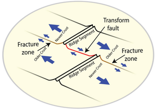
A fracture zone is a linear feature on the ocean floor—often hundreds, even thousands of kilometers long—resulting from the action of offset mid-ocean ridge axis segments. They are a consequence of plate tectonics. Lithospheric plates on either side of an active transform fault move in opposite directions; here, strike-slip activity occurs. Fracture zones extend past the transform faults, away from the ridge axis; are usually seismically inactive, although they can display evidence of transform fault activity, primarily in the different ages of the crust on opposite sides of the zone.
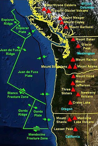
The Mendocino triple junction (MTJ) is the point where the Gorda plate, the North American plate, and the Pacific plate meet, in the Pacific Ocean near Cape Mendocino in northern California. This triple junction is the location of a change in the broad tectonic plate motions which dominate the west coast of North America, linking convergence of the northern Cascadia subduction zone and translation of the southern San Andreas Fault system. This region can be characterized by transform fault movement, the San Andreas also by transform strike slip movement, and the Cascadia subduction zone by a convergent plate boundary subduction movement. The Gorda plate is subducting, towards N50ºE, under the North American plate at 2.5–3 cm/yr, and is simultaneously converging obliquely against the Pacific plate at a rate of 5 cm/yr in the direction N115ºE. The accommodation of this plate configuration results in a transform boundary along the Mendocino Fracture Zone, and a divergent boundary at the Gorda Ridge. This area is tectonically active historically and today. The Cascadia subduction zone is capable of producing megathrust earthquakes on the order of MW 9.0.

The Explorer Ridge is a mid-ocean ridge, a divergent tectonic plate boundary located about 241 km (150 mi) west of Vancouver Island, British Columbia, Canada. It lies at the northern extremity of the Pacific spreading axis. To its east is the Explorer plate, which together with the Juan de Fuca plate and the Gorda plate to its south, is what remains of the once-vast Farallon plate which has been largely subducted under the North American plate. The Explorer Ridge consists of one major segment, the Southern Explorer Ridge, and several smaller segments. It runs northward from the Sovanco Fracture Zone to the Queen Charlotte triple junction, a point where it meets the Queen Charlotte Fault and the northern Cascadia subduction zone.

The Macquarie triple junction is a geologically active tectonic boundary located at 61°30′S161°0′E at which the historic Indo-Australian plate, Pacific plate, and Antarctic plate collide and interact. The term triple junction is given to particular tectonic boundaries at which three separate tectonic plates meet at a specific, singular location. The Macquarie triple junction is located on the seafloor of the southern region of the Pacific Ocean, just south of New Zealand. This tectonic boundary was named in respect to the nearby Macquarie Island, which is located southeast of New Zealand.

The 1,600 kilometres (990 mi) long Macquarie Fault Zone is a major right lateral-moving transform fault along the seafloor of the south Pacific Ocean which runs from New Zealand southwestward towards the Macquarie Triple Junction. It is also the tectonic plate boundary between the Australian plate to the northwest and the Pacific plate to the southeast. As such it is a region of high seismic activity and recorded the largest strike-slip event on record up to 23 May 1989, of at least 8.0
The Queen Charlotte triple junction is a geologic triple junction where three tectonic plates meet: the Pacific plate, the North American plate, and the Explorer plate. The three plate boundaries which intersect here are the Queen Charlotte Fault, the northern Cascadia subduction zone, and the Explorer Ridge. The Queen Charlotte triple junction is currently positioned adjacent to the Queen Charlotte Sound near the Dellwood Knolls off the coast of Vancouver Island. 10 Ma to 1.5 Ma prior to the triple junction's current location, it was located southwest of Vancouver Island The movements of the triple junction have been characterized by two major shifts in the Pacific-North American Tertiary plate tectonic record. First, at approximately 40 Ma the relative plate motions switched from orthogonal convergence to right-lateral strike slip. The variance in location of the triple junction may have also been related to the formation of an independent basin block. This formation could have been produced by fore-arc bending of the Pacific plate, due to oblique underthrusting prior to 1 Ma which produced stresses sufficient to break the Pacific plate and isolate the block. Transpression of 15–30 mm/yr since 5 Ma has been taking place, as well as varying amounts of both transpression and transtension occurring before then. To the northwest of the triple junction the Pacific plate currently has 15 degrees of oblique convergence, passing under the North American plate along the Queen Charlotte transform fault zone. The Explorer plate is a small chunk of the Juan de Fuca plate that broke away from the Juan de Fuca plate about 3.5 Ma and has moved much slower with respect to North America.
This is a list of articles related to plate tectonics and tectonic plates.

The Eltanin Fault System is a series of six or seven dextral transform faults that offset the Pacific-Antarctic Ridge, a spreading zone between the Pacific plate and the Antarctic plate. This is extending by up to 7.93 cm/year (3.12 in/year). It was named after the oceanographic ship USNS Eltanin.

The Pacific Ocean evolved in the Mesozoic from the Panthalassic Ocean, which had formed when Rodinia rifted apart around 750 Ma. The first ocean floor which is part of the current Pacific plate began 160 Ma to the west of the central Pacific and subsequently developed into the largest oceanic plate on Earth.

A leaky transform fault is a transform fault with volcanic activity along a significant portion of its length producing new crust. In addition to the regular strike-slip motion observed at transform boundaries, an oblique extensional component is present, resulting in motion of the plates that is not parallel to the plate boundary. This opens the fault, allowing melt to break through and cool on the ocean floor, producing new crust. This extensional component can come from a slight shift in the position of a plate's Euler Pole. In order to accommodate oblique motion along the plate boundary, these leaky transform faults can break up into a series of small transforms linked by short segments of spreading ridges. These new transforms will follow small circles centred on the new Euler Pole.
The Hjort Trench is a linear topographic depression south of Macquarie Island in the southwest Pacific Ocean. Geologically, the depression is considered to be the seafloor expression of an ocean-ocean subduction zone, where the Australian plate is thrusting beneath the Pacific plate. As the southernmost portion of the Macquarie Ridge complex, the Hjort Trench lies in an area of diagonal convergence produced by the transform fault evolution of the Emerald Fracture Zone. Frequent seismic events, most less than 20 km (12 mi) deep, characterize the transpression along this plate boundary.

The Chile Ridge, also known as the Chile Rise, is a submarine oceanic ridge formed by the divergent plate boundary between the Nazca plate and the Antarctic plate. It extends from the triple junction of the Nazca, Pacific, and Antarctic plates to the Southern coast of Chile. The Chile Ridge is easy to recognize on the map, as the ridge is divided into several segmented fracture zones which are perpendicular to the ridge segments, showing an orthogonal shape toward the spreading direction. The total length of the ridge segments is about 550–600 km.
In the early morning hours of Friday 24 December 2004, a moment magnitude 8.1 earthquake struck a remote area of the southern Tasman Sea. Its epicentre was located roughly 360 km (224 mi) northwest of the Auckland Islands of New Zealand, and roughly 600 km (373 mi) north of Macquarie Island of Australia. Shaking was reportedly felt as far as Tasmania and the South Island. The event was a complex intraplate earthquake within the Australian plate, which generated a small tsunami.
In the afternoon of Wednesday 25 March 1998, a very large magnitude 8.1 earthquake struck a remote area of the Southern Ocean. Its epicentre was located roughly 450 km (280 mi) north of George V Land and roughly 700 km (435 mi) northwest of the Balleny Islands in Antarctica. Due to the remote location of the earthquake, there were no reports of anyone feeling any shaking or any damage being caused. The event was a complex intraplate earthquake within the Antarctic plate. To date it is the largest recorded earthquake in Antarctica, and is the largest recorded earthquake to have been caused by post-glacial rebound. The earthquake occurred in an area which previously had very little seismic activity, and so such a large event was unprecedented in the seismic record.
