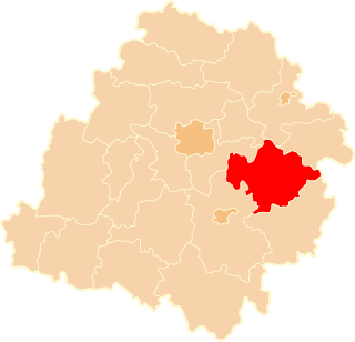
Glinnik is a village in the administrative district of Gmina Lubochnia, within Tomaszów Mazowiecki County, Łódź Voivodeship, in central Poland. It lies approximately 7 kilometres (4 mi) south-east of Lubochnia, 9 km (6 mi) north-east of Tomaszów Mazowiecki, and 51 km (32 mi) south-east of the regional capital Łódź.
Małecz is a village in the administrative district of Gmina Lubochnia, within Tomaszów Mazowiecki County, Łódź Voivodeship, in central Poland. It lies approximately 4 kilometres (2 mi) west of Lubochnia, 12 km (7 mi) north of Tomaszów Mazowiecki, and 42 km (26 mi) south-east of the regional capital Łódź.
Albertów is a village in the administrative district of Gmina Lubochnia, within Tomaszów Mazowiecki County, Łódź Voivodeship, in central Poland. It lies approximately 4 kilometres (2 mi) east of Lubochnia, 11 km (7 mi) north-east of Tomaszów Mazowiecki, and 49 km (30 mi) south-east of the regional capital Łódź.
Brenica is a village in the administrative district of Gmina Lubochnia, within Tomaszów Mazowiecki County, Łódź Voivodeship, in central Poland. It lies approximately 4 kilometres (2 mi) north of Lubochnia, 14 km (9 mi) north of Tomaszów Mazowiecki, and 45 km (28 mi) east of the regional capital Łódź.
Cygan is a village in the administrative district of Gmina Lubochnia, within Tomaszów Mazowiecki County, Łódź Voivodeship, in central Poland. It lies approximately 8 kilometres (5 mi) south of Lubochnia, 7 km (4 mi) north-east of Tomaszów Mazowiecki, and 51 km (32 mi) south-east of the regional capital Łódź.
Czółna is a village in the administrative district of Gmina Lubochnia, within Tomaszów Mazowiecki County, Łódź Voivodeship, in central Poland. It lies approximately 4 kilometres (2 mi) north-east of Lubochnia, 14 km (9 mi) north of Tomaszów Mazowiecki, and 46 km (29 mi) east of the regional capital Łódź.
Dąbrowa is a village in the administrative district of Gmina Lubochnia, within Tomaszów Mazowiecki County, Łódź Voivodeship, in central Poland. It lies approximately 8 kilometres (5 mi) north-east of Lubochnia, 16 km (10 mi) north-east of Tomaszów Mazowiecki, and 50 km (31 mi) east of the regional capital Łódź.
Henryków is a village in the administrative district of Gmina Lubochnia, within Tomaszów Mazowiecki County, Łódź Voivodeship, in central Poland. It lies approximately 2 kilometres (1 mi) south-east of Lubochnia, 10 km (6 mi) north of Tomaszów Mazowiecki, and 47 km (29 mi) south-east of the regional capital Łódź.
Jasień is a village in the administrative district of Gmina Lubochnia, within Tomaszów Mazowiecki County, Łódź Voivodeship, in central Poland. It lies approximately 5 kilometres (3 mi) east of Lubochnia, 14 km (9 mi) north-east of Tomaszów Mazowiecki, and 49 km (30 mi) east of the regional capital Łódź.
Kierz is a village in the administrative district of Gmina Lubochnia, within Tomaszów Mazowiecki County, Łódź Voivodeship, in central Poland. It lies approximately 3 kilometres (2 mi) north of Lubochnia, 13 km (8 mi) north of Tomaszów Mazowiecki, and 44 km (27 mi) south-east of the regional capital Łódź.
Kochanów is a village in the administrative district of Gmina Lubochnia, within Tomaszów Mazowiecki County, Łódź Voivodeship, in central Poland. It lies approximately 3 kilometres (2 mi) east of Lubochnia, 11 km (7 mi) north-east of Tomaszów Mazowiecki, and 48 km (30 mi) south-east of the regional capital Łódź.
Lubochnia-Górki is a village in the administrative district of Gmina Lubochnia, within Tomaszów Mazowiecki County, Łódź Voivodeship, in central Poland. It lies approximately 2 kilometres (1 mi) south-west of Lubochnia, 10 km (6 mi) north of Tomaszów Mazowiecki, and 45 km (28 mi) south-east of the regional capital Łódź.
Marianka is a village in the administrative district of Gmina Lubochnia, within Tomaszów Mazowiecki County, Łódź Voivodeship, in central Poland. It lies approximately 6 kilometres (4 mi) south-east of Lubochnia, 7 km (4 mi) north-east of Tomaszów Mazowiecki, and 49 km (30 mi) south-east of the regional capital Łódź.
Nowy Glinnik is a village in the administrative district of Gmina Lubochnia, within Tomaszów Mazowiecki County, Łódź Voivodeship, in central Poland. It lies approximately 6 kilometres (4 mi) south-east of Lubochnia, 11 km (7 mi) north-east of Tomaszów Mazowiecki, and 51 km (32 mi) south-east of the regional capital Łódź.
Nowy Jasień is a village in the administrative district of Gmina Lubochnia, within Tomaszów Mazowiecki County, Łódź Voivodeship, in central Poland. It lies approximately 4 kilometres (2 mi) east of Lubochnia, 13 km (8 mi) north-east of Tomaszów Mazowiecki, and 48 km (30 mi) south-east of the regional capital Łódź.
Nowy Olszowiec is a village in the administrative district of Gmina Lubochnia, within Tomaszów Mazowiecki County, Łódź Voivodeship, in central Poland. It lies approximately 4 kilometres (2 mi) east of Lubochnia, 13 km (8 mi) north-east of Tomaszów Mazowiecki, and 48 km (30 mi) south-east of the regional capital Łódź.
Olszowiec is a village in the administrative district of Gmina Lubochnia, within Tomaszów Mazowiecki County, Łódź Voivodeship, in central Poland. It lies approximately 3 kilometres (2 mi) east of Lubochnia, 11 km (7 mi) north-east of Tomaszów Mazowiecki, and 48 km (30 mi) south-east of the regional capital Łódź.
Osiedle Nowy Glinnik is a village in the administrative district of Gmina Lubochnia, within Tomaszów Mazowiecki County, Łódź Voivodeship, in central Poland. It lies approximately 5 kilometres (3 mi) south of Lubochnia, 7 km (4 mi) north-east of Tomaszów Mazowiecki, and 48 km (30 mi) south-east of the regional capital Łódź.
Rzekietka is a village in the administrative district of Gmina Lubochnia, within Tomaszów Mazowiecki County, Łódź Voivodeship, in central Poland. It lies approximately 4 kilometres (2 mi) north of Lubochnia, 14 km (9 mi) north of Tomaszów Mazowiecki, and 44 km (27 mi) east of the regional capital Łódź.
Tarnowska Wola is a village in the administrative district of Gmina Lubochnia, within Tomaszów Mazowiecki County, Łódź Voivodeship, in central Poland. It lies approximately 6 kilometres (4 mi) north-west of Lubochnia, 15 km (9 mi) north of Tomaszów Mazowiecki, and 41 km (25 mi) east of the regional capital Łódź.