
An aquifer is an underground layer of water-bearing permeable rock, rock fractures or unconsolidated materials.

The water table is the upper surface of the zone of saturation. The zone of saturation is where the pores and fractures of the ground are saturated with water. It can also be simply explained as the depth below which the ground is saturated.

Hydrogeology is the area of geology that deals with the distribution and movement of groundwater in the soil and rocks of the Earth's crust. The terms groundwater hydrology, geohydrology, and hydrogeology are often used interchangeably.
Hydraulic conductivity, symbolically represented as , is a property of vascular plants, soils and rocks, that describes the ease with which a fluid can move through pore spaces or fractures. It depends on the intrinsic permeability of the material, the degree of saturation, and on the density and viscosity of the fluid. Saturated hydraulic conductivity, Ksat, describes water movement through saturated media. By definition, hydraulic conductivity is the ratio of velocity to hydraulic gradient indicating permeability of porous media.

Hydraulic head or piezometric head is a specific measurement of liquid pressure above a vertical datum.
Watertable control is the practice of controlling the height of the water table by drainage. Its main applications are in agricultural land and in cities to manage the extensive underground infrastructure that includes the foundations of large buildings, underground transit systems, and extensive utilities.
Groundwater models are computer models of groundwater flow systems, and are used by hydrogeologists. Groundwater models are used to simulate and predict aquifer conditions.
In hydrogeology, groundwater flow is defined as the "part of streamflow that has infiltrated the ground, entered the phreatic zone, and has been discharged into a stream channel or springs; and seepage water." It is governed by the groundwater flow equation. Groundwater is water that is found underground in cracks and spaces in the soil, sand and rocks. Where water has filled these spaces is the phreatic saturated zone. Groundwater is stored in and moves slowly through layers or zones of soil, sand and rocks: aquifers. The rate of groundwater flow depends on the permeability and the hydraulic head.

Soil salinity control relates to controlling the problem of soil salinity and reclaiming salinized agricultural land.
Well drainage means drainage of agricultural lands by wells. Agricultural land is drained by pumped wells to improve the soils by controlling water table levels and soil salinity.
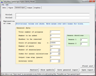
SahysMod is a computer program for the prediction of the salinity of soil moisture, groundwater and drainage water, the depth of the watertable, and the drain discharge in irrigated agricultural lands, using different hydrogeologic and aquifer conditions, varying water management options, including the use of ground water for irrigation, and several crop rotation schedules, whereby the spatial variations are accounted for through a network of polygons.

SaltMod is computer program for the prediction of the salinity of soil moisture, groundwater and drainage water, the depth of the watertable, and the drain discharge (hydrology) in irrigated agricultural lands, using different (geo)hydrologic conditions, varying water management options, including the use of ground water for irrigation, and several cropping rotation schedules. The water management options include irrigation, drainage, and the use of subsurface drainage water from pipe drains, ditches or wells for irrigation.
The groundwater energy balance is the energy balance of a groundwater body in terms of incoming hydraulic energy associated with groundwater inflow into the body, energy associated with the outflow, energy conversion into heat due to friction of flow, and the resulting change of energy status and groundwater level.
An agricultural drainage system is a system by which water is drained on or in the soil to enhance agricultural production of crops. It may involve any combination of stormwater control, erosion control, and watertable control.

Agricultural hydrology is the study of water balance components intervening in agricultural water management, especially in irrigation and drainage.
GSSHA is a two-dimensional, physically based watershed model developed by the Engineer Research and Development Center of the United States Army Corps of Engineers. It simulates surface water and groundwater hydrology, erosion and sediment transport. The GSSHA model is used for hydraulic engineering and research, and is on the Federal Emergency Management Agency (FEMA) list of hydrologic models accepted for use in the national flood insurance program for flood hydrograph estimation. Input is best prepared by the Watershed Modeling System interface, which effectively links the model with geographic information systems (GIS).
Dewatering is the removal of water from solid material or soil by wet classification, centrifugation, filtration, or similar solid-liquid separation processes, such as removal of residual liquid from a filter cake by a filter press as part of various industrial processes.

Catchment hydrology is the study of hydrology in drainage basins. Catchments are areas of land where runoff collects to a specific zone. This movement is caused by water moving from areas of high energy to low energy due to the influence of gravity. Catchments often do not last for long periods of time as the water evaporates, drains into the soil, or is consumed by animals.

A drainage equation is an equation describing the relation between depth and spacing of parallel subsurface drains, depth of the watertable, depth and hydraulic conductivity of the soils. It is used in drainage design.
DPHM-RS is a semi-distributed hydrologic model developed at University of Alberta, Canada.

