Endsleigh Gardens

Last updated

Friends House from Endsleigh Gardens Friends Meeting House, Euston from Endsleigh Gardens, London WC1 - geograph.org.uk - 731459.jpg
Friends House from Endsleigh Gardens

Endsleigh Gardens is a street in the Bloomsbury district of central London, in the London Borough of Camden. It runs south-west to north-east from Gordon Street to Woburn Place. The south-west end becomes Gower Place after the junction with Gordon Street. Taviton Street and Endsleigh Street run off the south side.

Contents

Endsleigh Gardens was formerly the south side of Euston Square, which in 1878 was the site of the "Euston Square Murder". In 1879 the Metropolitan Board of Works renamed the street Endsleigh Gardens in response to local requests.

Euston Square Murder

Hannah Dobbs, acquitted of the murder of Matilda Hacker, on the cover of a Police News special edition, c. 1879 Police News Euston Square Mystery cover Hannah Dobbs.jpg
Hannah Dobbs, acquitted of the murder of Matilda Hacker, on the cover of a Police News special edition, c. 1879

Endsleigh Gardens was originally the southern part of Euston Square. In 1877 or 1878, number four Euston Square was the site of a murder that became popularly known as the "Euston Square Murder" after the body of Matilda Hacker was found in the coal cellar of the house in 1879. [2] She had last been seen in 1877. [3]

Hannah Dobbs, a former servant at the house and mistress of the leaseholder Severin Bastendorff, was arrested after it was found that she had pawned some of Hacker's possessions. In 1879 she was tried for murder at the Old Bailey, but acquitted due to lack of evidence. [1] [2]

Renaming

As of 25 September 1879, the Metropolitan Board of Works of London recorded the receipt of a letter from the Vestry of Saint Pancras, asking that the south side of Euston Square be renamed Endsleigh Gardens, and the houses renumbered. The vestry had received the request from George Cubitt, M. P., a freeholder of the south side of Euston Square, along with a petition signed by "nearly the whole of the leaseholders and occupiers of the houses there". [4] The vestry meeting had voted in favour, 69 to 3. [4]

As of 28 November 1879, a committee reported to the Metropolitan Board of Works in favour of the request, [5] and as of 5 December 1879, the change was moved, seconded and resolved. [6]

The reasons for the request are not recorded in the Board of Works' minutes. Some accounts suggest that the name was changed to avoid the notoriety of the Euston Square Murder. [7] [8] As early as 1884 The Building News noted, in discussing various name changes, that "A little while before the inhabitants of the north [sic] side of Euston-square tried to bury the murderous memories attached thereto beneath the name of Endsleigh-gardens." [9]

Buildings

Friends House is on the north side of the street between Endsleigh Gardens and the Euston Road. [10]

A 1953 Ordnance Survey map shows on the south side the Endsleigh Hotel on the corner with Gordon Street, a YWCA hostel and the Caledonian Christian Club between Taviton Street and Endsleigh Street, and the Cora Hotel at the east end on the corner with Upper Woburn Place. On the north side is Drayton House on the corner with Gordon Street, Friends House, and a weights and measures office for the London County Council. [11]

Notable residents

Residents of the street have included:

On 10 September 1889, the poet and novelist Amy Levy killed herself at the family home at No 7, aged 27, by carbon monoxide poisoning after suffering from depression. [15] [16] There has been some campaigning for a blue plaque there to remember her. [17] Oscar Wilde described her as "a girl who has a touch of genius in her work". [16] [18]

In the 1890s, there were reports of prostitution in the area. Resident James Stock complained to the Metropolitan Police of "the fearful prevalence… of a gross state of street prostitution attended by features of a very disgusting character, particularly between the hours of 10 and 12 at which it is not fit for any respectable female to walk about and young men cannot do so without molestation." [19]

Historic maps

Related Research Articles

<span class="mw-page-title-main">King's Cross, London</span> Area of central London in England

King's Cross is a district in the London Boroughs of Camden and Islington, it’s on either side of Euston Road, in the outskirts of north London and central London, England, 1.5 miles (2.4 km) north of Charing Cross. It is bordered by Barnsbury to the north, Clerkenwell to the southeast, Angel to the east, Holborn and Bloomsbury to the south, Euston to the west and Camden Town to the northwest. It is served by two major rail termini, St Pancras and King's Cross. King's Cross station is the terminus of one of the major rail routes between London and the North.

<span class="mw-page-title-main">Metropolitan Board of Works</span> Principal instrument of London-wide government from 1855 until 1889

The Metropolitan Board of Works (MBW) was the upper tier of local government for London between 1856 and 1889, primarily responsible for upgrading infrastructure. It also had a parks and open spaces committee which set aside and opened up several landmark parks. The metropolis, which the board served, included substantial parts of Middlesex, Surrey, and Kent throughout the 33 years leading up to the advent of county councils. This urban zone lay around the medieval-sized City of London but plans to enact a similar body in 1837 failed. Parliament finally passed the Metropolis Management Act 1855 which dissolved a short-lived building office and a sewers commission and made the Board effective as of December that year. The board endured until it was succeeded by London County Council, as its directly elected, direct successor, in March 1889.

<span class="mw-page-title-main">Metropolitan Borough of Westminster</span>

The Metropolitan Borough of Westminster was a metropolitan borough in the County of London, England, from 1900 to 1965.

<span class="mw-page-title-main">Metropolitan Borough of St Marylebone</span> Metropolitan borough of England

The Metropolitan Borough of St Marylebone was a metropolitan borough of the County of London from 1900 to 1965. It was based directly on the previously existing civil parish of St Marylebone, Middlesex, which was incorporated into the Metropolitan Board of Works area in 1855, retaining a parish vestry, and then became part of the County of London in 1889.

<span class="mw-page-title-main">Metropolitan Borough of St Pancras</span> Metropolitan borough of England

St Pancras was a civil parish and metropolitan borough in London, England. It was an ancient parish in the county of Middlesex, governed by an administrative vestry. The parish was included in the area of responsibility of the Metropolitan Board of Works in 1855 and became part of the County of London in 1889. The parish of St Pancras became a metropolitan borough in 1900, following the London Government Act 1899, with the parish vestry replaced by a borough council. In 1965 the borough was abolished and its former area became part of the London Borough of Camden in Greater London.

<span class="mw-page-title-main">Euston Square</span> Location in London

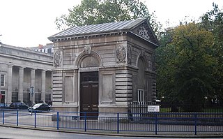
Euston Square is a large square in the London Borough of Camden in Central London. It lies on Euston Road, and Euston railway station and Euston bus station are on its northernmost side. Although “Euston Square” strictly refers to the square, in day to day use the name is often used to refer to Euston Square tube station, whose entrance is at the junction of Euston Road and North Gower Street. The southern half of the square was built over in the 1920s, leaving Euston Square Gardens on the north side in front of Euston station.

<span class="mw-page-title-main">Strand District (Metropolis)</span> A former local government district within the metropolitan area of London, England

Strand was a local government district within the metropolitan area of London, England, from 1855 to 1900.

<span class="mw-page-title-main">Southwark Christchurch</span> Historic parish in London

Christchurch was a civil parish in the metropolitan area of London, England. It was located south of the River Thames straddling either side of Blackfriars Road. It originated as the manor of Paris Garden in the parish of St Margaret, Southwark. The parish of St Margaret was replaced by St Saviour in 1541 and then in 1670 the area was split off as a parish in its own right when Christ Church was constructed. It was prone to flooding and was not heavily built upon until after 1809. In 1855 the parish was included in the metropolitan area of London where local government was reformed. The parish was united with St Saviour to form part of the St Saviour's District. When the district was abolished in 1900 the parish became part of the Metropolitan Borough of Southwark. It was abolished as a civil parish in 1930. The area now forms the northwestern part of the London Borough of Southwark.

<span class="mw-page-title-main">Digimap</span>

Digimap is a web mapping and online data delivery service developed by the EDINA national data centre for UK academia. It offers a range of on-line mapping and data download facilities which provide maps and spatial data from Ordnance Survey, British Geological Survey, Landmark Information Group and OceanWise Ltd Ltd.,, Getmapping Ltd, the Environment Agency, OpenStreetMap, CollinsBartholomew Ltd, and various other sources.

Percy William Bunting was an English journalist.

<span class="mw-page-title-main">J. M. Brydon</span> Scottish architect

John McKean Brydon was a Scottish architect who developed a practice in designing public buildings, particularly hospitals, in London. He designed the St Peter's Hospital in Henrietta Street, Covent Garden (1880–84), the Hospital for Women in Euston Road, Chelsea Public Library (1890), and the London School of Medicine for Women in Huntley Street (1896). He also designed the Old Vestry Hall at the rear of the Chelsea Town Hall on King's Road, as well as the Government Offices Great George Street, which today house the Treasury, HM Revenues and Customs and part of the Cabinet Office.

<span class="mw-page-title-main">Trump Street</span> Street in the City of London

Trump Street is a street in the City of London that was originally known as Trumpadere Street, probably after the trumpet or horn makers who once worked there or in the adjacent Trump Alley. It was built after the Great Fire of London (1666) but completely destroyed by bombing during the Second World War and has since been entirely rebuilt.

<span class="mw-page-title-main">Blossom's Inn</span> Staging post

Blossom's Inn was a tavern which stood in Lawrence Lane in the City of London from the 14th century until 1855. It became a substantial coaching inn and was used as a staging post by carriers of goods. In the 19th century, the lease was bought and it became the parcel depot of the Great Eastern Railway. Its name was used for a major property development at the end of the 20th century and the site is now part of the large complex of 30 Gresham Street.

<span class="mw-page-title-main">Lawrence Lane, London</span>

Lawrence Lane is a street in the City of London that runs from Trump Street in the south to Gresham Street in the north. Its final section in the north is pedestrianised. An alley also joins it to King Street in the north. It once ran south to join Cheapside but that end was blocked following post-Second World War rebuilding. It was known as St Lawrence Lane from the 13th to the 18th centuries due to its proximity to the church of St Lawrence Jewry and until King Street was built was the main route from Cheapside to the London Guildhall.

<span class="mw-page-title-main">Bull and Mouth Inn</span> Former coaching inn in the City of London

The Bull and Mouth Inn was a coaching inn in the City of London that dated from before the Great Fire of London in 1666. It was located between Bull and Mouth Street in the north and Angel Street in the south. It was once an important arrival and departure point for coaches from all over Britain, but particularly for the north of England and Scotland. It became the Queen's Hotel in 1830 but was demolished in 1887 or 1888 when new post office buildings were built in St Martin's Le Grand.

<span class="mw-page-title-main">Milk Street, London</span> Street in the City of London

Milk Street in the City of London, England, was the site of London's medieval milk market. It was the location of the parish church of St Mary Magdalen which was destroyed in the Great Fire of London in 1666 and then of Honey Lane Market and the City of London School. The street was seriously damaged by German bombing during the Second World War and has since been completely rebuilt. Nothing remains of its former buildings.

<span class="mw-page-title-main">Pinewood Hospital</span> Hospital in Pinewood, England

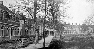
The Pinewood Hospital was a hospital in Pinewood, near Crowthorne, England, for the treatment of people suffering from tuberculosis. It was located in a pine wood as pine trees were thought to be beneficial in the treatment of the disease. It opened as the London Open Air Sanatorium in 1901 before becoming the Pinewood Sanatorium. It treated casualties of the First and Second World Wars and after the second, began to treat general thoracic patients as tuberculosis became less prevalent. It closed in 1966.

<span class="mw-page-title-main">Taviton Street</span>

Taviton Street is a street in the Bloomsbury district of central London, in the London Borough of Camden. It runs between Endsleigh Gardens in the north and Gordon Square and Endsleigh Place in the south. University College London's School of Slavonic and East European Studies moved into new buildings on the western side in 2005.

<span class="mw-page-title-main">Endsleigh Street</span>

Endsleigh Street is in the Bloomsbury district of central London, in the London Borough of Camden, England. It connects Endsleigh Gardens to the north to Endsleigh Place and Tavistock Square to the south.

<span class="mw-page-title-main">Euston Square Gardens</span>

Euston Square Gardens is a public garden on Euston Road in the London Borough of Camden.

References

  1. 1 2 Terrible Awful Horrid Murder and the Court of Public Opinion. Off the Pedestal, Indiana University Bloomington. Retrieved 21 March 2018.
  2. 1 2 Unsolved murders of women in Victorian London. Jan Bondeson, The History Press. Retrieved 21 March 2018.
  3. Aston, Mark (2005). Foul Deeds and Suspicious Deaths in Hampstead, Holburn and St Pancras. Barnsley: Wharncliffe Books. p. 92. ISBN   978-1-903425-94-7.
  4. 1 2 Metropolitan Board of Works (London, England) (1879). Minutes of proceedings of the Metropolitan Board of Works. London, England: Guildhall Library. p. 347. Retrieved 15 July 2018.
  5. Metropolitan Board of Works (London, England) (1879). Minutes of proceedings of the Metropolitan Board of Works. London, England: Guildhall Library. pp. 717–718. Retrieved 15 July 2018.
  6. Metropolitan Board of Works (London, England) (1879). Minutes of proceedings of the Metropolitan Board of Works. London, England: Guildhall Library. p. 774. Retrieved 15 July 2018.
  7. "Home Industries", Journal of the Royal Society of Arts , Vol. 59, No. 3031 (23 December 1910), pp. 146–148 (p. 148) "An instance of the name of a place being changed owing to its association with a murder is the case of the Euston-square mystery in the 'seventies. A petition resulted in the south side of Euston-square becoming Endsleigh-gardens."
  8. "Euston Road" in Christopher Hibbert; Ben Weinreb; John Keay; Julia Keay (2008). The London Encyclopaedia (3rd ed.). London: Pan Macmillan. p. 277. ISBN   978-0-230-73878-2.
  9. "Our office table". The Building News and Engineering Journal. 46: 617. 18 April 1884. Retrieved 15 July 2018.
  10. Ordnance Survey map, Digimap. Retrieved 12 March 2018. (subscription required)
  11. 1953 Ordnance Survey map, Digimap. Retrieved 5 March 2018.
  12. Thomas, Frances (2013). Christina Rossetti: A Biography. Little, Brown Book Group. p. 237. ISBN   978-1-4055-2500-8 . Retrieved 3 March 2018.
  13. 1 2 3 4 "Euston Square – British History Online". www.british-history.ac.uk. Retrieved 3 March 2018.
  14. 1 2 3 London County Council; London Survey Committee (1900). Survey of London. London: Joint Publishing Committee Representing the London County Council and the London Survey Committee. p. 117. Retrieved 15 July 2018.
  15. Selected Poetry of Amy Levy (1861–1889). Representative Poetry Online. Retrieved 21 March 2018.
  16. 1 2 The tragic poet Oscar Wilde called a genius. Jennifer Lipman, Jewish Chronicle, 26 April 2013. Retrieved 21 March 2018.
  17. The Persephone Letter. Archived 3 March 2018 at the Wayback Machine Persephone Books, 18 September 2016 Retrieved 21 March 2018.
  18. "A brief introduction to the works of Amy Levy". www.victorianweb.org. Retrieved 3 March 2018.
  19. Bartley, Paula (2000). Prostitution prevention and reform in England, 1860-1914 . London: Routledge. p.  158. ISBN   978-0415214575.
  20. 1874 Ordnance Survey map, Digimap. Retrieved 5 March 2018. (subscription required)
  21. 1895 Ordnance Survey map, Digimap. Retrieved 5 March 2018. (subscription required)
  22. 1953 Ordnance Survey map, Digimap. Retrieved 5 March 2018. (subscription required)

51°31′36.7″N00°07′49.6″W / 51.526861°N 0.130444°W / 51.526861; -0.130444