Related Research Articles

Kilolo is one of the four districts of the Iringa Region of Tanzania. It is bordered to the north and east by the Morogoro Region, to the south by Mufindi District and to the west by the Iringa Rural District. The district is home to the Udzungwa Mountains National Park.

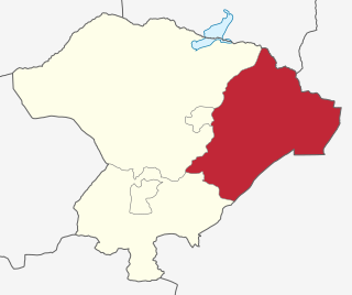
Kilosa District is one of the six districts of the Morogoro Region of Tanzania. Its administrative seat is the town of Kilosa. Kilosa District covers 14,918 square kilometres (5,760 sq mi). It is bordered to the north by the Manyara Region, to the northeast by the Tanga Region, to the east by Mvomero District, to the southeast by Morogoro Rural District, to the south by Kilombero District, to the southwest by the Iringa Region and to the west by the Dodoma Region. Kilosa District is home to Mikumi National Park.

Hanang District is one of the six districts of the Manyara Region of Tanzania. It is bordered to the north by the Mbulu District and Babati Rural District, to the southeast by the Dodoma Region and to the southwest by the Singida Region. Mount Hanang is located within the boundaries of the district.
Mahasoa is a rural municipality in Madagascar. It belongs to the district of Ihosy, which is a part of Ihorombe Region. The population was 24877 inhabitants in 2018.
Ambanisarike is a town and commune in Madagascar. It belongs to the district of Ambovombe, which is a part of Androy Region. The population of the commune was estimated to be approximately 8,000 in 2001 commune census.

Ambila is a rural municipality in Madagascar. It belongs to the district of Manakara, which is a part of Fitovinany. The population of the commune was estimated to be approximately 17,000 in 2001 commune census.
Mlowo is an administrative ward in Mbozi District, Songwe Region, Tanzania. According to the 2002 census, the ward has a total population of 17,663.
Arash is an administrative ward in the Ngorongoro District of the Arusha Region of Tanzania. According to the 2002 census, Arash has a total population of 8,503.
Digodigo is an administrative ward in the Ngorongoro District of the Arusha Region of Tanzania. According to the 2002 census, the ward has a total population of 10,831. Digodigo is central part of Sale Division, it is endowed with water for irrigation system therefore able to provides all type of vegetables and fruits to the district headquarters as the other part of the district is dry. Digo digo is the second largest developed area and center of business within the districts with more than 50 retail shops,5 quest houses, and other more public services as the area is developing very fast
Nainokanoka is an administrative ward in the Ngorongoro District of the Arusha Region of Tanzania, and approximately 300 km north of Dodoma, the capital of the country. The word Nainokanoka means place of mountains in Maasai. According to the 2002 census, the ward has a total population of 15,606.
Ngorongoro is an administrative ward in the Ngorongoro District of the Arusha Region of Tanzania. The ward is home to the Ngorongoro Crater. According to the 2002 census, the ward has a total population of 9,807.
Soit Sambu is an administrative ward in the Ngorongoro District of the Arusha Region of Tanzania. According to the 2002 census, the ward has a total population of 13,147.
Mbuguni is an administrative ward in the Meru District of the Arusha Region of Tanzania. The road that goes to Mererani, Manyara Region actually passes through Mbuguni ward. Making Mbuguni a trade route for the Tanzanite gemston. According to the 2002 census, the ward had a total population of 14,880.
Idifu is an administrative ward in the Dodoma Rural district of the Dodoma Region of Tanzania. According to the 2002 census, the ward has a total population of 6,241.
Suruke is an administrative ward in the Kondoa district of the Dodoma Region of Tanzania. According to the 2002 census, the ward has a total population of 11,711.
Massa is an administrative ward in the Mpwapwa district of the Dodoma Region of Tanzania, located south zone of Mpwapwa District that is among the wards of Rudi Division. According to the 2002 census, the ward has a total population of 9,812. who mostly practice agricultural activities; livestoke keeping and farming activities for both commercial and food products.
Hogoro is an administrative ward in the Kongwa district of the Dodoma Region of Tanzania. According to the 2002 census, the ward has a total population of 29,221.
Ntuntu is an administrative ward in the Singida Rural district of the Singida Region of Tanzania. According to the 2002 census, the ward has a total population of 13,983.
Mgori is an administrative ward in the Singida Rural district of the Singida Region of Tanzania. According to the 2002 census, the ward has a total population of 10,777.

Mangwe District is a district of the Province Matabeleland South in Zimbabwe. It is divided into 17 wards. Some of the wards are Ngwizi, Mphoengs, Sanzukwi, Sangulube, Maninji, Madabe, Mbakwe, Empandeni, Mayobodo, Mambale, Makorokoro, Tshitshi, and Marula. Some villages found in this district are Bulu, Kweneng, Togotsweu. Mangwe used to be a part of bigger district which was known as Bulilimamangwe. Bulilimamangwe was then divided into 3 districts now known as Mangwe, Bulilima and Plumtree.
References
- ↑ "2002 Population and Housing Census General Report". Government of Tanzania. Archived from the original on 2005-02-18. Retrieved 2008-08-19.