Selela

Last updated

Selela
Kata ya Selela
Blik op Selela in Rift Valley.jpg
View at Selela in the Rift Valley
Tanzania location map.svg
Red pog.svg
Selela
Location of Selela
Coordinates: 3°12′18″S35°56′38″E / 3.205°S 35.944°E / -3.205; 35.944
Country Flag of Tanzania.svg  Tanzania
Region Arusha Region
District Monduli District
Ward Selela
Population
 (2022) [1]
  Total14,275
Time zone UTC+3 (EAT)

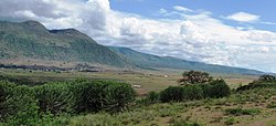
Selela is the name of a village and an administrative ward in the Monduli District of the Arusha Region of Tanzania. The name Selela means Clean water in the Maasai language.

Contents

In 2022 the Tanzania National Bureau of Statistics report there were 14,275 [2] people in the ward (55% female - 45% male; average household size: 4.3), from 9,712 in 2016 and 8,703 in 2012. [3] [1]

Education

In Selela there are a number of schools:
- Selela Primary School is the largest and counts almost 1,200 children. .
- In the subvillage of Mbaash (which means 'between the mountains' in Maasai language), about 16 km from Selela, there's also primary school which counts more than 700 children. This is an official boarding school. The head teacher is Mr. Paakwai Meitamei.
- A third primary school is about 7 km from Selela village and is called Ndinyika Primary School, with more than children. Ndinyika means 'far from the boma' in Maasai language. .
- Oltinga Secondary School is built on the escarpment and overviews Selela village. This (boarding) school has grown quite rapidly in the last few years and now hosts around 800 students from the region around Selela. The name comes from the Maasai word for 'water basin', which is located near to the school. Head teacher is Mr. Kitali.

Health

Selela has a dispensary and since 2016 a dispensary at Mbaash has opened as well. Selela and Mbaash are supported by Tanzania Support Foundation. This NGO, founded in The Netherlands, especially helped the Selela schools with several supplies (for example school desks, computers, books, exercise books, storage cupboards et cetera), but also construction materials for classrooms, teachers houses, dormitories and water storage units. Also laptops and tablets have been provided for the schools. Furthermore the medical dispensaries received, for example, medical supplies, wheelchairs, walkers and a solar installation.

Economy

Every Wednesday there's a market day at Selela village. In the village there are some guesthouses and small shops.

Related Research Articles

<span class="mw-page-title-main">Sumve</span> Ward in Kwimba, Mwanza, Tanzania

Sumve is a ward located in the Kwimba District of the Mwanza Region, in Tanzania. Sumve's residents are predominantly from the Wasukuma tribe, the largest in Tanzania, but some of Sumve's institutions employ Wahaya, Wajita, Wakerewe, Wanyamwezi and others from neighboring tribes. Therefore, many of the residents speak Kisukuma along with Swahili, the national language. In 2016 the Tanzania National Bureau of Statistics report there were 18,514 people in the ward, from 16,436 in 2012.

<span class="mw-page-title-main">Bagamoyo District, Pwani</span> District of Pwani Region, Tanzania

Bagamoyo District Council is one of eight administrative districts of Pwani Region in Tanzania. The District covers an area of 945 km2 (365 sq mi). The district is surrounded by the Chalinze District to the north and west, the Zanzibar Channel to the east, the Kibaha District to the south, and the Kinondoni District to the south-east in the Dar es Salaam Region. The district is comparable in size to the land area of Turks and Caicos Islands. The district capital is at Bagamoyo. 1n 2016 the Tanzania National Bureau of Statistics report there were 106,484 people in the district, from 311,740 in 2012, of which 97,660 where in current district wards. The decrease being from splitting of the district and creation of the Chalinze District in 2015.

<span class="mw-page-title-main">Mbarali District</span> District of Mbeya Region, Tanzania

Mbarali District is one of the seven districts of Mbeya Region, Tanzania. It is bordered to the north by Iringa region and east by Njombe region. To the south the district is bordered by Mbeya Rural District and to the west by Chunya District.

Igurusi is an administrative ward in the Mbarali district of the Mbeya Region of Tanzania. In 2022 the Tanzania National Bureau of Statistics report there were more than 28,000 people in the ward, from 24,573 in 2016.

Pinyinyi is an administrative ward in the Ngorongoro District of the Arusha Region of Tanzania. The area was historically part of Sonjo people's ancestral land. The Masai arrived in the 1950s, eventually the Sonjo abandoned Hajaro in 1987 due to Masai violence over grazing land. The Maasai renamed it Pinyinyi. In 2016 the Tanzania National Bureau of Statistics report there were 5,230 people in the ward, from 8,482 in 2012.

Sale is an administrative ward in the Ngorongoro District of the Arusha Region of Tanzania. In 2016 the Tanzania National Bureau of Statistics report there were 4,892 people in the ward, from 4,384 in 2012.

Makuyuni is an administrative ward in the Monduli district of the Arusha Region of Tanzania. In 2016 the Tanzania National Bureau of Statistics report there were 12,529 people in the ward, from 11,228 in 2012.

<span class="mw-page-title-main">Monduli Mjini, Monduli District</span> Ward and district capital of the Monduli District in the Arusha Region of Tanzania

Monduli Mjini is an administrative ward and district capital located in the Monduli District of the Arusha Region of Tanzania.The ward is totally surrounded by the Engototo ward. In 2016 the Tanzania National Bureau of Statistics report there were 8,699 people in the ward, from 7,796 in 2012. The average elevation of Monduli Mjini is 1,553m.

<span class="mw-page-title-main">Makurumla</span> Ward of Ubungo District, Dar es Salaam Region

Makurumla is an administrative ward in Ubungo District of the Dar es Salaam Region in Tanzania. The Kinondoni Municipal District's Ndugumbi ward borders the ward on the north. Mzimuni Ward to the east, Mburahati and Mabibo to the south were its neighbors. Lastly, via Manzese ward towards the west. In 2016 the Tanzania National Bureau of Statistics report there were 79,331 people in the ward, from 63,352 in 2012.

<span class="mw-page-title-main">Ilala, Ilala District</span> Ward of the Ilala District in the Dar es Salaam Region of Tanzania

Ilala or Ilala Ward is an administrative ward of the Ilala District of the Dar es Salaam Region in Tanzania. The Kigogo ward of the Kinondoni District borders the ward to the north, and the Mchikichini and Gerezani wards to the east. The Temeke District wards of Keko, Chang'ombe, and Temeke border the ward to the south. Buguruni encircles the ward to the west. In 2016 the Tanzania National Bureau of Statistics report there were 38,923 people in the ward, from 31,083 in 2012.

<span class="mw-page-title-main">Kisutu</span> Ward of Ilala District, Dar es Salaam Region

Kisutu is an administrative ward of the Ilala Municipical Council of the Dar es Salaam Region in Tanzania. Upanga East ward and Kivukoni ward both border the ward to the north and north-east. The ward is bordered to the south by Mchafukoge ward and to the west by Jangwani ward. The ward hosts the Channel 10 Television Station formerly known as Dar es Salaam Television Station at Zaramo Street in Kisutu ward. In 2016 the Tanzania National Bureau of Statistics report there were 10,404 people in the ward, from 8,308 in 2012.

<span class="mw-page-title-main">Mchafukoge</span> Ward and district capital of Ilala District, Dar es Salaam Region

Mchafukoge is an administrative ward and district capital of the Ilala district in the Dar es Salaam Region of Tanzania. Kisutu and Kivukoni wards form the ward's northern boundary. The Dar es Salaam Harbor forms its eastern border. The Temeke District wards of Kurasini and Keko border it on the south. Kariakoo and Jangwani wards border the ward to the west. The ward is home to the Uhuru Monument, the Central Railway Station, and the headquarters for Tanzania Revenue Authority at Mapato House. In 2016 the Tanzania National Bureau of Statistics reported there were 13,384 people in the ward, from 10,688 in 2012.

<span class="mw-page-title-main">Pembamnazi</span> Ward of the Kigamboni District in the Dar es Salaam Region of Tanzania

Pembamnazi, also known as Pemba Mnazi, is an administrative ward in the Kigamboni district of Dar es Salaam Region in Tanzania. The Indian Ocean forms the ward's eastern and southern boundaries. The Pwani Region's Mkuranga District's Shungubweni and Vianzi Wards are to the west. The ward is bordered to the north by the wards of Kisarawe II and Kimbiji. In 2016 the Tanzania National Bureau of Statistics report there were 12,112 people in the ward, from 9,672 in 2012.

<span class="mw-page-title-main">Vijibweni</span> Ward of the Kigamboni District in the Dar es Salaam Region of Tanzania

Vijibweni is an administrative ward in the Kigamboni district of the Dar es Salaam Region of Tanzania. The Tungi and Mjimwema form the ward's northern and eastern borders, respectively. In the Temeke District, it is bordered to the south by Kibada and to the west by Kijichi, Mtoni, and Kurasini. Kurasini is connected to Vijibweni by the iconic Nyerere Bridge. With seven major firms situated there, Vijibweni is home to the largest manufacturing industries in the entire District. In 2016 the Tanzania National Bureau of Statistics report there were 36,327 people in the ward, from 29,010 in 2012.

Iguguno is an administrative ward in the Mkalama District of the Singida Region of Tanzania. The town is popular business center for crops like cereals and sunflower. It is arguably the most developed town in the district. There are a few schools both primary and secondary in the town. In 2016 the Tanzania National Bureau of Statistics report there were 21,548 people in the ward, from 25,860 in 2012.

Gangilonga is an administrative ward in the located in Iringa Urban District of the Iringa Region of Tanzania. The ward covers and area of 5.557 square kilometres (2.146 sq mi) with an altitude of 1,703 metres (5,587 ft).

<span class="mw-page-title-main">Uwemba</span> Ward in Njombe, Iringa, Tanzania

Uwemba is a town and ward in Njombe District in the Iringa Region of the Tanzanian Southern Highlands. Uwemba has a big Benedictines monastery and Secondary school. Economic activities includes agriculture and business.

<span class="mw-page-title-main">Kagera, Kigoma-Ujiji</span> Ward in Kigoma-Ujiji District, Kigoma Region

Kagera is an administrative ward in Kigoma-Ujiji District of Kigoma Region in Tanzania. The ward covers an area of 24.3 km2 (9.4 sq mi), and has an average elevation of 786 m (2,579 ft). In 2016 the Tanzania National Bureau of Statistics report there were 9,950 people in the ward, from 9,040 in 2012.

Buhanda is an administrative ward in Kigoma-Ujiji District of Kigoma Region in Tanzania. The ward covers an area of 5.5 km2 (2.1 sq mi), and has an average elevation of 864 m (2,835 ft). In 2016 the Tanzania National Bureau of Statistics report there were 8,397 people in the ward, from 7,629 in 2012.

Mwanga Kusini is an administrative ward in Kigoma-Ujiji District of Kigoma Region in Tanzania. The ward covers an area of 3.5 km2 (1.4 sq mi), and has an average elevation of 787 m (2,582 ft). In 2016 the Tanzania National Bureau of Statistics report there were 17,976 people in the ward, from 16,331 in 2012.

References

  1. 1 2 2016 Makadirio ya Idadi ya Watu katika Majimbo ya Uchaguzi kwa Mwaka 2016, Tanzania Bara [Population Estimates in Administrative Areas for the Year 2016, Mainland Tanzania](PDF) (Report) (in Swahili). Dar es Salaam, Tanzania: National Bureau of Statistics. 1 April 2016. Archived (PDF) from the original on 27 December 2021. Retrieved 3 July 2022.
  2. Administrative Units Population Distribution Report - Tanzania Mainland - Population Distribution by Administrative Areas (PDF) (Report). Dar es Salaam, Tanzania: National Bureau of Statistics. 1 December 2022. Retrieved 29 February 2024.
  3. 2012 Population and Housing Census - Population Distribution by Administrative Areas (PDF) (Report). Dar es Salaam, Tanzania: National Bureau of Statistics. 1 March 2013. Archived (PDF) from the original on 26 March 2022. Retrieved 3 July 2022.