Engela Constituency

Last updated

Engela constituency (red) in the Ohangwena Region of Namibia Wahlkreis Engela (2014).svg
Engela constituency (red) in the Ohangwena Region of Namibia

Engela is an electoral constituency in the Ohangwena Region of northern Namibia. It had 13,743 registered voters in 2020. [1] It is named after the settlement of Engela, today part of the town Helao Nafidi. Engela is home to one of the biggest hospitals in Namibia, Engela State Hospital.

Contents

The constituency covers an area of 296 km2 (114 sq mi). It had a population of 24,271 in 2011, up from 21,832 in 2001. [2]

Politics

As is common in all constituencies of former Ovamboland, Namibia's ruling SWAPO Party has dominated elections since independence. In the 2004 regional election SWAPO candidate Nghidinihamba Urias Ndilula received 6,774 of the 6,802 votes cast. [3]

In the 2015 regional election SWAPO also won by a landslide. Its candidate Jason Ndakunda gathered 5,372 votes, while the only opposition candidate, Laban Kanyiki of the Rally for Democracy and Progress (RDP), received 574 votes. [4] The 2020 regional election was also won by the SWAPO candidate. Elkan Hainghumbi received 4,431 votes, far ahead of Ngenokesho Nandeukeni of the Independent Patriots for Change (IPC), an opposition party formed in August 2020, who obtained 867 votes. [1]

Seasonal flooding

The constituency is usually affected by flood waters from Cunene Province in southern Angola when it receives good rainfall, leaving many areas submerged. This usually affects residents living in flood-prone areas in the constituency. Due to the flooding, schools are being closed, leaving learners trapped in their homes. Additionally, during flooding season, roads, buildings, and houses are damaged and livestock dies, affecting the community's livelihood in the constituency. [5] [6]

Related Research Articles

<span class="mw-page-title-main">Oshikoto Region</span> Region in Namibia

Oshikoto is one of the fourteen regions of Namibia, named after Lake Otjikoto. Its capital is Omuthiya. Further major settlements in the region are Tsumeb, Otjikoto's capital until 2008, and Oniipa. As of 2020, Oshikoto had 112,170 registered voters.

<span class="mw-page-title-main">Omusati Region</span> Region in Namibia

Omusati is one of the fourteen regions of Namibia, its capital is Outapi. The towns of Okahao, Oshikuku and Ruacana as well as the self-governed village Tsandi are situated in this region. As of 2020, Omusati had 148,834 registered voters.

<span class="mw-page-title-main">Omaheke Region</span> Region in Namibia

Omaheke is one of the fourteen regions of Namibia, the least populous region. Its capital is Gobabis. It lies in eastern Namibia on the border with Botswana and is the western extension of the Kalahari Desert. The self-governed villages of Otjinene, Leonardville and Witvlei are situated in the region. As of 2020, Omaheke had 48,594 registered voters.

<span class="mw-page-title-main">Ohangwena Region</span> Region in Namibia

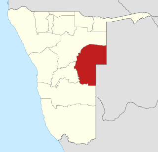
Ohangwena is one of the fourteen regions of Namibia, its capital is Eenhana. Major settlements in the region are the towns Eenhana and Helao Nafidi as well as the self-governed village of Okongo and the proclaimed settlements Ongha, Ongenga and Omungwelume. As of 2020, Ohangwena had 150,724 registered voters.

<span class="mw-page-title-main">Oranjemund Constituency</span> Electoral constituency in ǁKaras region, Namibia

Oranjemund is a constituency in the ǁKaras Region of Namibia. It covers an area of 4,623 km2 (1,785 sq mi) and had a population of 9,837 in 2011, up from 7,789 in 2001. The main towns are the district capital Oranjemund and the mining town of Rosh Pinah, the constituency also contains the Sendelingsdrift border post. As of 2020 the constituency had 7,894 registered voters.

<span class="mw-page-title-main">Eenhana Constituency</span> Electoral constituency in the Ohangwena region of northern Namibia

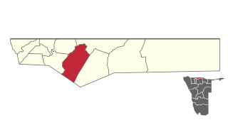
Eenhana is an electoral constituency in the Ohangwena Region of Namibia, on the border to Angola. It had 15,912 registered voters in 2020. The constituency covers an area of 1,112 km2 (429 sq mi) and contains the town of Eenhana and the surrounding area. The constituency office is located in Eenhana. The constituency had a population of 21,089 in 2011, up from 18,690 in 2001.

<span class="mw-page-title-main">Endola Constituency</span> Electoral constituency in the Ohangwena region of northern Namibia

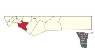
Endola is an electoral constituency in the Ohangwena Region of Namibia, on the border of Angola. It had 14,100 registered voters in 2020. The constituency covers an area of 328 km2 (127 sq mi) and contains numerous settlements, including part of Ongha. The constituency office is situated at Endola. The constituency had a population of 25,591 in 2011, up from 24,804 in 2001.

<span class="mw-page-title-main">Epembe Constituency</span> Electoral constituency in the Ohangwena region of northern Namibia

Epembe is a constituency in the Ohangwena Region of northern Namibia. It had 6,489 registered voters in 2020.

<span class="mw-page-title-main">Ohangwena Constituency</span> Electoral constituency in the Ohangwena region of northern Namibia

Ohangwena is a constituency in the Ohangwena Region of northern Namibia. It had 17,539 inhabitants in 2004 and 13,181 registered voters in 2020. It is named after the settlement of Ohangwena, today part of the town Helao Nafidi.

<span class="mw-page-title-main">Okongo Constituency</span> Electoral constituency in the Ohangwena region of northern Namibia

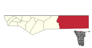
Okongo is a constituency in the Ohangwena Region of Namibia, on the border to Angola. It had a population of 25,698 in 2011, up from 21,551 in 2001. In 2020 it had 12,562 registered voters.

<span class="mw-page-title-main">Omundaungilo Constituency</span> Electoral constituency in the Ohangwena region of northern Namibia

Omundaungilo is an electoral constituency in the Ohangwena Region of Namibia, on the border to Angola. It has 8,085 inhabitants in 2004 and 6,642 registered voters in 2020.

<span class="mw-page-title-main">Omulonga Constituency</span> Electoral constituency in the Ohangwena region of northern Namibia

Omulonga is a constituency in the Ohangwena Region of northern Namibia. It had 13,585 registered voters in 2020. The constituency office is located at Onamukulo, along the Ondobe-Oshigambo district road. Omulonga constituency covers an area of 597 km2 (231 sq mi). It had a population of 32,581 in 2011, up from 31,465 in 2001.

<span class="mw-page-title-main">Ondobe Constituency</span> Electoral constituency in the Ohangwena region of northern Namibia

Ondobe is a constituency in the Ohangwena Region of Namibia. It had 32,726 inhabitants in 2004 and 16,286 registered voters in 2020.

<span class="mw-page-title-main">Ongenga Constituency</span> Electoral constituency in the Ohangwena region of northern Namibia

Ongenga is a constituency in the Ohangwena Region of Namibia, on the border to Angola. It had 21,474 in 2004 and 12,682 registered voters in 2020.

<span class="mw-page-title-main">Oshikango Constituency</span> Electoral constituency in the Ohangwena region of northern Namibia

Oshikango is a constituency in the town of Helao Nafidi in the Ohangwena Region of northern Namibia, on the border to Angola. It had 27,599 inhabitants in 2004 and 17,480 registered voters in 2020. It is named after the settlement of Oshikango, today part of the town Helao Nafidi.

<span class="mw-page-title-main">Ruacana Constituency</span> Electoral constituency in the Omusati region of northern Namibia

Ruacana Constituency is an electoral constituency in the Omusati Region of Namibia on the border to Angola. It had 10,722 inhabitants in 2004 and 9,285 registered voters in 2020. Its district capital is the town of Ruacana.

<span class="mw-page-title-main">Okaku Constituency</span> Electoral constituency in the Oshana region of northern Namibia

Okaku Constituency is an electoral constituency in the Oshana Region of Namibia. It had 19,262 inhabitants in 2004 and 10,384 registered voters in 2020. Its district capital is the settlement of Okaku. Okaku falls under the Ondonga Traditional Authority.

<span class="mw-page-title-main">Uuvudhiya Constituency</span> Electoral constituency in Oshana region, Namibia

Uuvudhiya Constituency is an electoral constituency in the Oshana Region of Namibia. The constituency office is situated in Engombe. In 2004 Uuvudhiya had 4,357 inhabitants and 2,869 registered voters.

<span class="mw-page-title-main">Okakarara Constituency</span> Electoral constituency in Namibia

Okakarara Constituency is an electoral constituency in the Otjozondjupa Region of Namibia. It had 21,336 inhabitants in 2004 and 16,221 registered voters in 2020. The constituency consists of the town of Okakarara and the surrounding rural area.

<span class="mw-page-title-main">Oshikunde Constituency</span> Electoral constituency in the Ohangwena region of northern Namibia

Oshikunde Constituency is an electoral constituency in the Ohangwena Region of Namibia. As of 2020, it has 8,062 registered voters.

References

  1. 1 2 "Regional Council 2020 Election Results". Interactive map. Electoral Commission of Namibia. 18 January 2021. Archived from the original on 12 June 2021. Retrieved 14 July 2021.
  2. "Chapter 2: Population Structure, Composition and Density" (PDF). Ohangwena 2011 Census Regional Profile. Namibia Statistics Agency. p. 4. Retrieved 1 January 2025.
  3. "Electoral Act, 1992: Notification of Result of General Election for Regional Councils" (pdf). Government Gazette of the Republic of Namibia. No. 3366. Government of Namibia. 3 January 2005. p. 8.
  4. "Regional Council Election Results 2015". Electoral Commission of Namibia. 3 December 2015. p. 13. Archived from the original on 8 December 2015. Retrieved 12 June 2016.
  5. Nepembe, Panduleni (2024). "Flood waters enters Engela Constituency in Ohangwena Region". NBC . Retrieved 3 January 2025.
  6. Shikololo, A (2 February 2023). "Flood wreaks havoc in Ohangwena". New Era .

17°26′S15°52′E / 17.433°S 15.867°E / -17.433; 15.867