Engelbert, Netherlands

Last updated
Engelbert
Engelbert - Cafe Engelstede.jpg
Coffeeshop of the former railway station
2010-NL-P01-Groningen-positiekaart-gemnamen.jpg
Red pog.svg
Engelbert
Location in the province of Groningen in the Netherlands
Netherlands location map.svg
Red pog.svg
Engelbert
Engelbert (Netherlands)
Coordinates: 53°12′27″N6°38′45″E / 53.2074°N 6.6457°E / 53.2074; 6.6457
Country Netherlands
Province Groningen
Municipality Groningen
Area
[1]
  Total3.36 km2 (1.30 sq mi)
Elevation
[2]
2.3 m (7.5 ft)
Population
 (2021) [1]
  Total890
  Density260/km2 (690/sq mi)
Postal code
9723 [1]
Dialing code 050

Engelbert is a village in the Dutch province of Groningen. It is a part of the municipality of Groningen.

Contents

History

The village was first mentioned in 1323 as "de Egniberde", and means "settlement of Egge (person)". [3] Engelbert developed in the Early Middle Ages in the forest-rich moorland of the Hunze region. The area around Engelbert was gradually cultivated. [4]

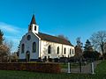
The Dutch Reformed church is an elongated church without transepts. The oldest parts date from the 13th and 14th century. The church was restored in 1779. [4]

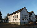
In 1811, Engelbert became part of the municipality of Noorddijk. The village was home to 193 people in 1840. [5] A railway station opened in 1926 on the Groningen to Weiwerd railway line. A tall building in three parts was constructed to serve as railway station. The line closed in 1941, and the building is now a residential home. [6]

In 1969, Engelbert became part of the municipality of Groningen. [5] Since 2005, Engelbert is located within the Meerstad project, a planned suburban town. It is stated that Engelbert will retain its village identity, [7] [5] however the postal authorities have already placed Engelbert under Groningen, [8] and in the statistics, the population of Engelbert is added to the total for the city of Groningen. [1]

Recreation

The natural swimming pool and camping Engelbert is located near the village. The pool contains many big carps ( cyprinidae ) and is up to 7 metres (23 ft) deep. It has a 5 metres (16 ft) high diving tower, and there is a lifeguard on duty between 13:00 and 18:00. [9] [10]

Related Research Articles

<span class="mw-page-title-main">Groningen (province)</span> Northeasternmost province of the Netherlands

Groningen is the northeasternmost province of the Netherlands. It borders on Friesland to the west, Drenthe to the south, the German state of Lower Saxony to the east, and the Wadden Sea to the north. As of February 2020, Groningen had a population of 586,309 and a total area of 2,960 km2 (1,140 sq mi).

<span class="mw-page-title-main">Leek, Netherlands</span> Town and former municipality in Groningen, Netherlands

Leek is a village and former municipality in Groningen province in the northeastern Netherlands. The municipality, which bordered the Drenthe and Friesland provinces, was merged into the municipality of Westerkwartier on 1 January 2019.

<span class="mw-page-title-main">Swalmen</span> Village in Limburg, Netherlands

Swalmen is a town in the south-eastern Netherlands. The town is situated between the German border and the river Meuse.

<span class="mw-page-title-main">Zoetermeer</span> City and municipality in South Holland, Netherlands

Zoetermeer is a city in the Western Netherlands, in the province of South Holland. The municipality covers an area of 37.05 km2 (14.31 sq mi) of which 2.60 km2 (1.00 sq mi) is water. A small village until the late 1960s, it had 6,392 inhabitants in 1950. By 2013 this had grown to 123,328, making it the third largest population centre in the province of South Holland, after Rotterdam, The Hague and Leiden. While now a city in its own right, Zoetermeer started out as a suburb of The Hague and is still a part of the Greater The Hague urban area.

<span class="mw-page-title-main">Buitenpost</span> Village in Friesland, Netherlands

Buitenpost is a village in north-east Friesland in the Netherlands.

<span class="mw-page-title-main">Sauwerd</span> Village in Groningen, Netherlands

Sauwerd is a village in the municipality of Het Hogeland, Groningen, Netherlands. Until the local government reorganization of 1990 the village was the head of the former municipality of Adorp.

<span class="mw-page-title-main">Grijpskerk</span> Village in Groningen, Netherlands

Grijpskerk is a village in the Dutch province of Groningen. It is located in the municipality of Westerkwartier, about 18 km west of the city of Groningen.

<span class="mw-page-title-main">Gasselte</span> Village in Drenthe, Netherlands

Gasselte is a village in the Dutch province of Drenthe. Located in the municipality of Aa en Hunze, it is situated about 16 km east of Assen. In 2021, it had a population of 1,770.

<span class="mw-page-title-main">Gieten</span> Village in Drenthe, Netherlands

Gieten is a village in the Dutch province of Drenthe. It is a part of the municipality of Aa en Hunze, and lies about 14 km east of Assen.

<span class="mw-page-title-main">1e Exloërmond</span> Village in Drenthe, Netherlands

1e Exloërmond is a village in the Dutch province of Drenthe. It is a part of the municipality of Borger-Odoorn, and lies about 18 km north of Emmen.

<span class="mw-page-title-main">Uitwierde</span> Village in Groningen, Netherlands

Uitwierde is a village in the Dutch province of Groningen. It is a part of the municipality of Eemsdelta, and lies about 26 km northeast of Groningen.

<span class="mw-page-title-main">Bellingwolde</span> Village in Groningen, Netherlands

Bellingwolde is a village with a population of 2,655 people in the municipality Westerwolde in the Netherlands. It is situated in the southeast of the region Oldambt, in the north of the region Westerwolde, and in the east of the province Groningen, at the border with Germany.

<span class="mw-page-title-main">Rilland</span> Village in Zeeland, Netherlands

Rilland is a village in the Dutch province of Zeeland. It is located in the municipality of Reimerswaal.

<span class="mw-page-title-main">Noorddijk, Groningen</span> Village in Groningen, Netherlands

Noorddijk is a village in the Dutch province of Groningen. It is located in the municipality of Groningen, about 5 km northeast of the city centre.

<span class="mw-page-title-main">Stedum</span> Village in Groningen, Netherlands

Stedum is a village in the Dutch province of Groningen. It is located in the municipality of Eemsdelta, about 15 km (9 mi) northeast of the city of Groningen.

<span class="mw-page-title-main">Glimmen</span> Village in Groningen, Netherlands

Glimmen is a village in the northeastern Netherlands. It is located in the municipality of Groningen, about 10 kilometres from the city. It had a population of around 1,342 in 2021. The river Drentsche Aa flows past the village, nearby the Huis te Glimmen, a stately home on the site.

<span class="mw-page-title-main">Dorkwerd</span> Village in Groningen, Netherlands

Dorkwerd is a small village in Groningen, the Netherlands. It is located in the municipality of Groningen, about 4 km northwest of the city center. Recent construction of new residential areas have brought the city to less than 500 meters from the village of Dorkwerd, and the postal authorities have placed it under Groningen.

<span class="mw-page-title-main">Kolham</span> Village in Groningen, Netherlands

Kolham is a village in the Dutch province of Groningen. It is part of the municipality of Midden-Groningen. In 1959, natural gas was discovered at Kolham. Later, it was revealed that Groningen gas field was the largest natural gas field in Europe.

<span class="mw-page-title-main">Schildwolde</span> Village in Groningen, Netherlands

Schildwolde is a village in the Dutch province of Groningen. It is part of the municipality of Midden-Groningen. It is known for its detached church tower from the 13th century.

<span class="mw-page-title-main">Visvliet</span> Village in Groningen, Netherlands

Visvliet is a village in the Dutch province of Groningen. It is part of the municipality of Westerkwartier, and is located near the river Lauwers, the border between Friesland and Groningen.

References

  1. 1 2 3 4 "Kerncijfers wijken en buurten 2021". Central Bureau of Statistics. Retrieved 8 April 2022.
  2. "Postcodetool for 9723AA". Actueel Hoogtebestand Nederland (in Dutch). Het Waterschapshuis. Retrieved 8 April 2022.
  3. "Engelbert - (geografische naam)". Etymologiebank (in Dutch). Retrieved 8 April 2022.
  4. 1 2 Ronald Stenvert & Redmer Alma (1998). "Engelbert" (in Dutch). Zwolle: Waanders. ISBN   90 400 9258 3 . Retrieved 8 April 2022.
  5. 1 2 3 "Engelbert". Plaatsengids (in Dutch). Retrieved 8 April 2022.
  6. "station Engelbert". Stationsweb (in Dutch). Retrieved 8 April 2022.
  7. "Meerstad in vogelvlucht". Toekomst Meerstad (in Dutch). Retrieved 8 April 2022.
  8. "Postcode 9723 in Groningen". Postcode bij adres (in Dutch). Retrieved 8 April 2022.
  9. "Natuurbad Engelbert". Duikers gids (in Dutch). Retrieved 8 April 2022.
  10. "Natuurbad Engelbert". Natuurlijk Noorden (in Dutch). Retrieved 8 April 2022.