
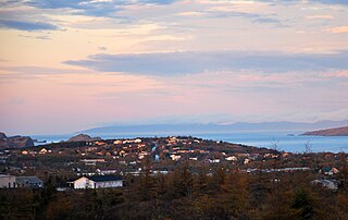
Dildo is an unincorporated place on the island of Newfoundland, in the province of Newfoundland and Labrador, Canada. It is located on the southeastern Dildo Arm of Trinity Bay about 60 kilometres west of St. John's. South Dildo is a neighbouring unincorporated community. The town's unusual name has brought it a certain amount of notoriety.

Whitbourne is a town on the Avalon Peninsula in Newfoundland and Labrador, Canada in Division 1.
Clarenville is a town on the east coast of Newfoundland in the province of Newfoundland and Labrador, Canada. Clarenville was incorporated in 1951 and is located in the Shoal Harbour valley fronting an arm of the Atlantic Ocean called Random Sound.
Chapel Arm is a settlement in Newfoundland, Canada, located at the southeast corner of Trinity Bay, approximately 100 km (62 mi) west of St. John's and two km from the Trans-Canada Highway.

Carbonear-Harbour Grace is a defunct provincial electoral district for the House of Assembly of Newfoundland and Labrador, Canada. In 2011 there were 9,205 eligible voters living within the district.

Trinity North is a provincial electoral district for the House of Assembly of Newfoundland and Labrador, Canada. As of 2011, there were 8,278 eligible voters living within the district.
The community of Hant's Harbour is an incorporated town having a population of 346 located on the east side of Trinity Bay on the Bay de Verde Peninsula, Newfoundland, Canada.

Harbour Grace is a town in Conception Bay on the Avalon Peninsula in the province of Newfoundland and Labrador, Canada. With roots dating back to the 16th century, it is one of the oldest towns in North America.
Belleoram is a village on the shores of Fortune Bay in the Canadian province of Newfoundland and Labrador.

Southport is a community in the Canadian province of Newfoundland and Labrador, located on the southern side of the entrance to Trinity Bay's Southwest Arm, about 41 km southeast of Clarenville. Its latitude and longitude are 48°02'59"N, 53°37'59"W.

Rose Blanche – Harbour le Cou is a small town on Newfoundland's southwest shore, about 45 km at the end of Route 470 from Port aux Basques. This community is located in a barren area on the east side of a small bay. In this bay there are 2 harbours that were mainly used to provide shelter for fishing vessels. Scenery includes the rugged granite coastline, and the white and rocky cliffs of "Diamond Cove". Its granite lighthouse was in operation from 1873 to the 1940s. After it was abandoned in the 1940s the building fell into ruins. The spiral stone staircase extends into the tower wall and kept the tower from collapsing while the remainder of the lighthouse fell to ruin. In 1999 the lighthouse was fully reconstructed and serves as a tourist attraction.
Bay Roberts is located on the north shore of Conception Bay on the northeastern Avalon Peninsula in the province of Newfoundland and Labrador, Canada. The growth of the local economy can be connected to the town's proximity to other major Newfoundland markets, by road and by water.
Heart's Delight-Islington is a town on the south side of Trinity Bay in the Canadian province of Newfoundland and Labrador. The town, located on Newfoundland and Labrador Route 80, was incorporated in 1973 by amalgamating the formerly independent settlements of Heart's Delight and Islington. The Post Office was established in 1954. The first Postmistress was Maggie Chislett.
Codroy is a community in the Codroy Valley of Newfoundland and Labrador, Canada.
NunatuKavut is an unrecognized Inuit territory in Labrador. The NunatuKavut people are the direct descendants of the Inuit that lived south of the Churchill or Grand River prior to European contact, with European influence from Basque and French whalers.
William Austin Oke was a newspaper publisher, politician, and District Court judge in Newfoundland. He represented Harbour Grace in the Newfoundland House of Assembly for three terms, from 1898 to 1908, as a Liberal.

Division No. 1, Subdivision E is an unorganized subdivision on the Avalon Peninsula in Newfoundland and Labrador, Canada. It is in Division 1 and contains the unincorporated communities of Broad Cove, Dildo, Green's Harbour, Harnum Point, Hopeall, New Harbour and Reids Room.
