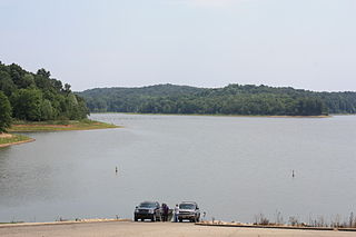
Patoka Lake is the second-largest reservoir in the U.S. state of Indiana and is spread across Dubois, Crawford, and Orange counties in southern Indiana.

The white crappie is a freshwater fish found in North America, one of the two species of crappies. Alternate common names for the species include goldring, silver perch, white perch and sac-a-lait. USS Goldring is named for the fish. The genus name Pomoxis refers to crappies' sharp operculum, while the species name annularis means 'having rings', i.e., it has vaguely vertical bars on the body.

Somerville Lake is a U.S. Army Corps of Engineers reservoir on Yegua Creek in the Brazos River basin, 10 miles (16 km) northwest of Brenham, Texas, United States. The town of Somerville in Burleson County is adjacent to the reservoir. The lake extends into portions of Burleson County, Washington County, and Lee County. The dam lies in Washington County. The dam and lake are managed by the Fort Worth District of the U.S. Army Corps of Engineers. The reservoir was officially impounded in 1967, and serves to provide flood control and water for irrigation for the communities downstream. Somerville Lake is a popular recreational destination.

George P. Cossar State Park is a public recreation area in the U.S. state of Mississippi located on the shores of Enid Lake, five miles (8.0 km) northeast of Oakland off Mississippi Highway 32.
Lake Fork Reservoir is a reservoir located in Wood, Rains, and Hopkins counties in the state of Texas, between the towns of Quitman, Alba, Emory, and Yantis, Texas.

The Dale Hollow Reservoir is a reservoir situated on the Kentucky/Tennessee border. The lake is formed by the damming of the Obey River, 7.3 miles (12 km) above its juncture with the Cumberland River at river mile 380. Portions of the lake also cover the Wolf River. Dale Hollow is one of four major flood control reservoirs for the Cumberland; the others being Percy Priest Lake, Lake Cumberland, and Center Hill Lake. It is also the site of Dale Hollow Lake State Park on the north (Kentucky) side.

Cave Run Lake, located south of Morehead, Kentucky, USA along Kentucky Route 801, is an 8,270-acre (33 km2) reservoir built by the U.S. Army Corps of Engineers. The 148 ft (45 m), half-mile dam construction began in 1965 and was completed in 1973. Cave Run Lake is in the northern part of the Daniel Boone National Forest. Cave Run Lake provides flood protection to the lower Licking River valley, supplies water to the area's communities, improves the Licking River's water flow conditions, and offers a habitat for various species of fish and wildlife. It is in Rowan, Morgan, Menifee, and Bath counties.
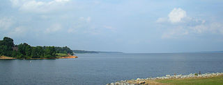
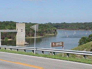
Taylorsville Lake is a 3,050-acre (1,230 ha) artificial lake or reservoir located mainly in Spencer County, Kentucky. As of 12/19/21 Taylorsville Lake has become a hotspot for migrating ducks. According to Central KY Waterfowlers the lake is currently holding a record number of waterfowl. It has been estimated over 20,000 ducks have been harvested in 3 days. Construction by the United States Army Corps of Engineers started in 1974, and flooding began in 1983. The total cost of the lake was $103 million. It is about 18.5 miles (29.8 km) long. Backwater areas of the lake are also located in Nelson County and Anderson County.
Saylorville Lake is a reservoir on the Des Moines River in Iowa, United States. It is located 11 miles (18 km) upstream from the city of Des Moines, and 214 miles (344 km) from the mouth of the Des Moines River at the Mississippi River. It was constructed as part of a flood control system for the Des Moines River as well as to aid in controlling flood crests on the Mississippi, of which the Des Moines is a tributary. The lake and dam is owned and operated by the U.S. Army Corps of Engineers, Rock Island District.
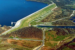
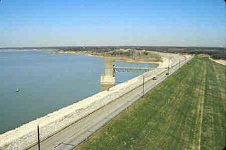
Sardis Lake is a 98,520-acre (398.7 km2) reservoir on the Tallahatchie River in Lafayette, Panola, and Marshall counties, Mississippi. Sardis Lake is impounded by Sardis Dam, located nine miles (14 km) southeast of the town of Sardis. It is approximately an hour drive from Memphis, Tennessee. The dam is 15,300 feet (4,700 m) long, has an average height of 97 feet (30 m), and a maximum height of 117 feet (36 m).

Arkabutla Lake is a reservoir on the Coldwater River in the U.S. state of Mississippi. It was created following the construction of the Arkabutla Dam in 1940 on the Coldwater River.

Wilson Lake is a reservoir in the U.S. state of Kansas, on the border of Russell County and Lincoln County. Built and managed by the U.S. Army Corps of Engineers for flood control, it is also used for wildlife management and recreation. Several parks are located along its shoreline, including Wilson State Park.

The John H. Kerr Reservoir is a reservoir along the border of the U.S. states of North Carolina and Virginia. The U.S. Army Corps of Engineers constructed the John H. Kerr Dam across the Roanoke River between 1947 and 1952 to produce hydroelectricity as well as for flood control. Kerr Lake is the largest lake in Virginia, with 850 miles (1,370 km) of shoreline located in Vance, Granville, and Warren counties in North Carolina, as well as Mecklenburg, Charlotte, and Halifax counties in Virginia. At its maximum capacity, it covers approximately 50,000 acres (200 km2) and is one of the largest reservoirs in the Southeastern United States. The name honors its Congressional sponsor, John H. Kerr, a North Carolina Democrat who supported creation of the lake. The lake supports recreational tourism in North Carolina and Virginia as described below.

Lavon Lake is a freshwater reservoir located in southeast Collin County, Texas, on the East Fork of the Trinity River near Wylie, off State Highway 78. It is commonly called Lake Lavon for commercial and recreational purposes, but Lavon Lake is its official name according to the U.S. Army Corps of Engineers. It was originally called Lavon Reservoir.

Barren River Lake State Resort Park is a 1,053-acre (426 ha) park located in Barren County, Kentucky and extending into parts of Allen County and Monroe County. Barren River Lake, its major feature, is an artificial lake created with the building of a 146-foot-high (45 m) dam by the U.S. Army Corps of Engineers begun in 1960. It covers approximately 10,000 acres (4,000 ha) and has 141 miles (227 km) of shoreline. The park was dedicated in 1965.
Taylorsville Lake State Park is a park encompassing 1,200 acres (490 ha) in Spencer County, Kentucky, roughly midway between Louisville and Lexington. Taylorsville Lake, its major feature, extends into parts of Anderson County and Nelson County.
East Fork State Park is 4,870-acre (1,970 ha) public recreation area located around the East Fork of the Little Miami River in Clermont County, twenty miles (32 km) southeast of central Cincinnati, Ohio, in the United States. It maintains the 33-mile "Steve Newman World-Walker" perimeter trail, camping, hiking, swimming, and boating opportunities. The state park has hosted junior and collegiate rowing races, including the US Rowing Youth National Championships. The park's main feature is William H. Harsha Lake, a 2,107-acre (853 ha) reservoir created in 1978. The lake's large earthen dam and smaller saddle dams are operated by the U.S. Army Corps of Engineers.
Grapevine Lake is a reservoir located in the North Texas region, about 20 mi (32 km) northwest of Dallas and northeast of Fort Worth. It was impounded in 1952 by the US Army Corps of Engineers when they dammed Denton Creek, a tributary of Trinity River.

Rathbun Lake was constructed and is operated by the U.S. Army Corps of Engineers. Located at Chariton River mile marker 142, approximately 7 miles (11 km) north of Centerville, Iowa, in Appanoose County, it is one of the largest lakes in Iowa. The lake was constructed to control flooding, provide recreation opportunities, abate stream pollution, fish and wildlife enhancement, and maintain minimum stream flow on the Chariton, Missouri, and Mississippi Rivers. The Chariton and South Fork of the Chariton River are the major sources of water flowing into Rathbun Lake.

Kanopolis Lake is a reservoir in Ellsworth County in the Smoky Hills of central Kansas, about 31 miles southwest of Salina and a few miles southeast of the town of Kanopolis. The lake is formed by Kanopolis Dam. Completed in 1948 as a flood control and water conservation project of the United States Army Corps of Engineers, the dam impounds the Smoky Hill River.


