Raetia was a province of the Roman Empire, named after the Rhaetian people. It bordered on the west with the country of the Helvetii, on the east with Noricum, on the north with Vindelicia, on the south-west with Transalpine Gaul and on the south with Venetia et Histria, a region of Roman Italy.

The Lech is a river in Austria and Germany. It is a right tributary of the Danube 255 kilometres (158 mi) in length with a drainage basin of 3,919 square kilometres (1,513 sq mi). Its source is located in the Austrian state of Vorarlberg, where the river rises from lake Formarinsee in the Alps at an altitude of 1,870 metres (6,120 ft). It flows in a north-north-easterly direction and crosses the German border, forming the Lechfall, a 12-metre-high (39 ft) waterfall; afterwards the river enters a narrow gorge. Leaving the Alps, it enters the plains of the Allgäu at Füssen at an elevation of 790 metres (2,580 ft) in the German state of Bavaria, where it used to be the location of the boundary with Swabia. The river runs through the city of Füssen and through the Forggensee, a man-made lake which is drained in winter. Here, it forms rapids and a waterfall.
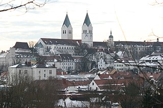
Freising is a town in Bavaria, Germany, and the capital of the Freising Landkreis (district), with a population of about 50,000.

Kamid el-Loz, also spelled Kamid al-Lawz, is located in West Bekaa, Lebanon. Its population numbers several thousand, mostly Sunni, people.

Bad Bocklet is a municipality in the district of Bad Kissingen in Bavaria in Germany. It is a market town and a health spa.
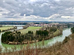
Denklingen is a municipality in the district of Landsberg in Bavaria in Germany. The former municipality of Epfach, which has a history back to the Roman period, is now part of Denklingen.

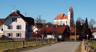
Kirchheim or Kirchheim in Schwaben is a municipality and a market town in the district of Unterallgäu in the region of Swabia (Schwaben) in the south-west of Bavaria, Germany. The town was greatly influenced by the Fugger family. North-east of the town lies the Augsburg Western Woods Nature Park.

Weiding is a municipality in the district of Schwandorf in Bavaria, Germany.

Hans-Georg Stephan is a German university professor specializing in European medieval archaeology and post-medieval archaeology.

The Bavarian State Archaeological Collection in Munich is the central museum of prehistory of the State of Bavaria, considered to be one of the most important archaeological collections and cultural history museums in Germany.

Hayo Vierck was a German archaeologist, who made a distinguished contribution to German Early Medieval archaeology through research in the industrial arts.
Joachim Werner was a German archaeologist who was especially concerned with the archaeology of the Early Middle Ages in Germany. The majority of German professorships with particular focus on the field of the Early Middle Ages were in the second half of the 20th century occupied by his academic pupils.
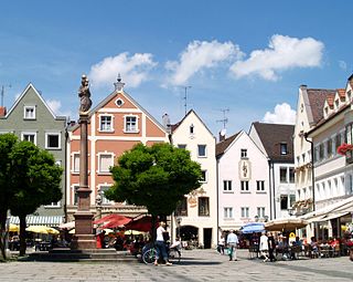
Weilheim in Oberbayern is a town in Germany, the capital of the district Weilheim-Schongau in the south of Bavaria. Weilheim has an old city-wall, historic houses and a museum.
Horst Wolfgang Böhme is a German archaeologist with a focus on Late Antiquity / Early Middle Ages and research into castles.
The Salzmünde Group or Salzmünde Culture is the name for a late group from the Funnelbeaker culture in central Saale-Elbe region of Germany, which existed between 3400 and 3000 BC during the Neolithic period.
The Holy Cross Church is the church of the Neuenwalde Convent. Convent and Holy Cross Church are owned by the Bremian Knighthood, based in Stade. However, church and parsonage, are used per usufruct by the Lutheran Neuenwalde Congregation in Neuenwalde, a locality of Geestland, Lower Saxony, Germany. Besides the Holy Cross Church, only used, the congregation uses and owns the chapel in Hymendorf.
Werner Huß is a German ancient historian.

The Neckar-Odenwald Limes is a collective term for two, very different early sections of the Upper Germanic-Rhaetian Limes, a Roman defensive frontier line that may have been utilised during slightly different periods in history. The Neckar-Odenwald Limes consists of the northern Odenwald Limes (Odenwaldlimes), a cross-country limes with camps, watchtowers and palisades, which linked the River Main with the Neckar, and the adjoining southern Neckar Limes (Neckarlimes), which in earlier research was seen as a typical 'riverine limes', whereby the river replaced the function of the palisade as an approach obstacle. More recent research has thrown a different light on this way of viewing things that means may have to be relativized in future. The resulting research is ongoing.

The ringwork on the Schießberg is a, now levelled, early medieval hillfort situated at a height of 422 m above sea level (NHN) on the Schießberg, about 1,100 metres northeast of the church of Unterstürmig, a village in the market municipality of Eggolsheim in the county of Forchheim in the south German state of Bavaria.
Werner Danckert was a German folk song researcher.