Upland is a borough in Delaware County, Pennsylvania, United States. Upland is governed by an elected seven-member borough council. The population was 3,239 at the 2010 census, up from 2,974 at the 2000 census.

Tulpehocken Creek is a 39.5-mile-long (63.6 km) tributary of the Schuylkill River in southeastern Pennsylvania in the United States, and during the American Canal Age, once provided nearly half the length of the Union Canal linking the port of Philadelphia, the largest American city and the other communities of Delaware Valley with the Susquehanna basin and the Pennsylvania Canal System connecting the Eastern seaboard to Lake Erie and the new settlements of the Northwest Territory via the Allegheny}, Monongahela. and Ohio Rivers at Pittsburgh.
Red Clay Creek is a 13.6-mile-long (21.9 km) tributary of White Clay Creek, running through southeastern Pennsylvania and northern Delaware in the United States. As of 2000, portions of the creek are under wildlife habitat protection.
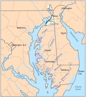
The Elk River is a tidal tributary of the Chesapeake Bay on the Eastern Shore of Maryland and on the northern edge of the Delmarva Peninsula. It is about 15 miles (24 km) long. As the most northeastern extension of the Chesapeake Bay estuary, it has served as one entrance to the Chesapeake & Delaware Canal since the 19th century. The canal and river now serve as one boundary of the Elk Neck Peninsula. The river flows through Cecil County, Maryland, with its watershed extending into New Castle County, Delaware and Chester County, Pennsylvania. Elkton, the county seat of Cecil County, is located at its head. Its total watershed area is 143 square miles (370 km2), with 21 square miles (54 km2) of open water, so its watershed is 15% open water. It is south and east of the North East River, and north of the Sassafras River.

Ridley Creek State Park is a 2,606-acre (1,055 ha) Pennsylvania state park in Edgmont, Middletown and Upper Providence Townships, Delaware County, Pennsylvania in the United States. The park, about 5 miles (8 km) north of the county seat of Media, offers many recreational activities, such as hiking, biking, fishing, and picnicking. Ridley Creek passes through the park. Highlights include a 5-mile (8 km) paved multi-use trail, a formal garden designed by the Olmsted Brothers, and Colonial Pennsylvania Plantation, which recreates daily life on a pre-Revolutionary farm. The park is adjacent to the John J. Tyler Arboretum. Ridley Creek State Park is just over 16 miles (26 km) from downtown, Philadelphia between Pennsylvania Route 352 and Pennsylvania Route 252 on Gradyville Road.

Brodhead Creek is a 21.9-mile-long (35.2 km) tributary of the Delaware River in the Poconos of eastern Pennsylvania in the United States.

Chester Creek is a 9.4-mile-long (15.1 km) tributary of the Delaware River in Delaware County, Pennsylvania in the United States.
Bushkill Creek is a 22.1-mile-long (35.6 km) tributary of the Delaware River in eastern Pennsylvania in the United States.
Big Bushkill Creek is a 30.1-mile-long (48.4 km) tributary of the Delaware River in the Poconos of eastern Pennsylvania in the United States.
Shohola Creek is a 29.0-mile-long (46.7 km) tributary of the Delaware River in the Poconos of eastern Pennsylvania in the United States.

Martins Creek is a 10.4-mile-long (16.7 km) tributary of the Delaware River in eastern Pennsylvania in the United States.

Martins Creek is a 20.4-mile-long (32.8 km) tributary of Tunkhannock Creek in northeastern Pennsylvania in the United States.

The Mason-Dixon Trail is a 195.9-mile (315.3 km), blue-blazed footpath that connects the Appalachian Trail with the Brandywine Trail, passing through Gifford Pinchot State Park and White Clay Creek Preserve in Pennsylvania and White Clay Creek State Park in Delaware. About 30 per cent of the "trail" is a route marked along public roads; the remainder is actual trail.
Manatawny Creek is an 18.2-mile-long (29.3 km) tributary of the Schuylkill River in Pennsylvania in the United States.
Salt Lick Creek is an 11.1-mile-long (17.9 km) tributary of the Susquehanna River in Susquehanna County, Pennsylvania in the United States.
Starrucca Creek is an 18.1-mile-long (29.1 km) tributary of the Susquehanna River in Susquehanna and Wayne counties, Pennsylvania in the United States.

Early in the 19th century, the Leiper Canal built in 1828-29 during the middle of the American canal age ran about 3 miles (5 km) along Crum Creek in Delaware County to its mouth in Eastern Pennsylvania's Delaware Valley carrying its owners quarried products to docks on the Delaware River tidewater until 1852.
Naamans Creek is a tributary of the Delaware River in northeast New Castle County, Delaware and southeast Delaware County, Pennsylvania The stream rises near the intersection of Foulk Road and Naamans Creek Road at 39°50′34″N75°29′32″W in Bethel Township, Pennsylvania, flows through Arden, Delaware, and discharges into the Delaware River at 39°48′19″N75°26′11″W in Claymont, Delaware. The creek is believed to be named after a Minqua chief who befriended the Swedish settlers of the area. A large tract of land along the creek was deeded to Governor Johan Risingh by chief Peminacka in 1655.