Related Research Articles
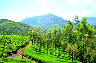
Munnar is a town and hill station located in the Idukki district of the southwestern Indian state of Kerala. Munnar is situated at around 1,600 metres (5,200 ft) above mean sea level, in the Western Ghats mountain range. Munnar is also called the "Kashmir of South India" and is a popular honeymoon destination.

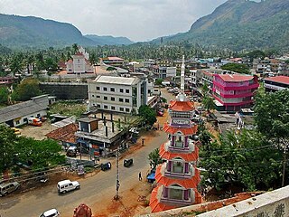
Idukki is one of the 14 districts in the Indian state of Kerala in the southwest of the country. It is the largest district in Kerala and lies amid the Cardamom Hills of Western Ghats in Kerala. Idukki district contains two municipal towns – Kattappana and Thodupuzha, and five taluks.

Kodaikanal is a town and hill station in Dindigul district in the state of Tamil Nadu, India. It is situated at an altitude of 2,225 m (7,300 ft) in the Palani hills of the Western Ghats. Kodaikanal was established in 1845 to serve as a refuge from the high temperatures and tropical diseases during the summer in the plains. It is a popular tourist destination and is referred to as the "Princess of Hill stations" with much of the local economy is based on the hospitality industry serving tourism. As per the 2011 census, the city had a population of 36,501.

Anamudi is a mountain located in Ernakulam district and Idukki district of the Indian state of Kerala. With an elevation of 2,695 metres (8,842 ft) and a topographic prominence of 2,479 metres (8,133 ft), it is the highest peak in the Western Ghats and in South India.

Eravikulam National Park is a 97 km2 national park located along the Western Ghats in the Idukki and Ernakulam districts of Kerala in India. The park is situated between 10º05'N and 10º20' north, and 77º0' and 77º10' east and is the first national park in Kerala. It was established in 1978.

Periyakulam is a major town and a municipality in Theni district, in the Madurai Region, South Indian state of Tamil Nadu. As of 2011, the town had a population of 42,976. Periyakulam is the northern gateway of the district.

Mattupetty Dam, near Munnar in Idukki District, is a storage concrete gravity dam built in the mountains of Kerala, India to conserve water for hydroelectricity. It has been a vital source of power and huge revenue for Idukki District. The large amount of perennially available water allows wild animals and birds to flourish. Construction of the dam was led by E.U. Philipose, Superintending Engineer, Kerala State Electricity Board. The height of the dam is 83.35 metres (273.5 ft) and the length is 237.74 metres (780.0 ft). Taluks through which the release flows are Udumpanchola, Devikulam, Kothamangalam, Muvattupuzha, Kunnathunadu, Aluva, Kodungalloor and Paravur.

Lakkom Water Falls, also known as Lakkam Waterfalls, is a tourist attraction located near Marayoor in the Idukki district of Kerala. These falls are part of the Eravikulam stream, which is a part of Eravikulam National Park and is one of the major tributaries of the Pambar River.

Kanthalloor is a village in Devikulam taluk, Idukki district, Kerala. It is a village nestled in the Western Ghats of India. The salubrious climate and the picturesque landscapes and wide variety of tropical crops coupled with the close proximity to Munnar, has transformed this village into a tourist destination.
Adimali is a town in the Idukki district of Kerala, in southwesternIndia. National Highway 185 is a highway in India running from Adimali to Kumily through Kattappana and ends in Adoor in Kerala. Adimaly is located on the National Highway 49, now NH 85, known as Kochi-Dhanushkodi National Highway, earlier known as the Kochi Madhura Highway (India) connecting Kochi and Madurai, India. From Adimaly, it is only 27 kilometers to Munnar, which is a famous hill station. The waterfalls Cheeyappara, Adimali waterfalls and Valara are located nearby. Pepper and cocoa cultivation is the main agricultural activity of this place. The Ponmudi Dam was constructed in 1963 across the Panniar river, nearly 15 km southeast of Adimali, on the way to Rajakkad.Thopramkudy is the nearest town. Adimali is known for its proximity to Munnar and natural environment. Adimali has almost all the basic facilities like roads, super markets, markets, educational institutions and hospitals.

The Cheeyappara Waterfall is on the Kochi - Madurai Highway, between Neriamangalam and Adimali. It is in Idukki district, Kerala, India.

The Kodaikanal–Munnar Road was located in Dindigul District and Theni District of Tamil Nadu and Idukki district of Kerala in South India. It covers 81 kilometers (50 mi) from Kodaikanal to Munnar. The road was improved by the British in 1942 as an evacuation route in preparation for a possible Japanese invasion of South India. With a maximum elevation of 2,480 meters (8,140 ft) just south of Vandaravu Peak, it was among the highest roads in India, south of the Himalayas, prior to its closure in 1990.
State Highway 16 is also known as Aluva - Munnar Road is a State Highway in Kerala that starts from Aluva and ends at Northern outlet road in Munnar. The highway is 57.3 km long.

The Govt.College of Engineering Munnar is situated in the Munnar hill station of the State of Kerala, India. College of Engineering Munnar is an Institute of higher learning established by Government of Kerala and is managed by the Center for Continuing Education Kerala ( CCEK ). The Institution was started in the year 2000 and is affiliated to APJ Abdul Kalam Technological University Kerala from 2015 admission onwards. The college is approved by All India Council for Technical Education (AICTE), New Delhi. It is one of the finest engineering institutions in Kerala.The Chairman of the Governing Body of the institution is the Hon’ble Minister for Education, Government of Kerala and the Vice-Chairman is the Principal Secretary (Higher Education) Government of Kerala.

Vagavurrai or Vaguvarrai is a village in Idukki district of Kerala, India. It is located 24 kilometers north of Munnar and 18 kilometer from Marayur on SH 17 connecting Munnar with Udumalpet, Tamil Nadu.

The KDHP Tea Museum is an industry and history museum situated in Munnar, a town in the Idukki district of Kerala in South India. Tata Tea Museum is its official name, but it's also known as Nullathanni Estate where it is located, or Kannan Devan Hills Plantation (KDHP) Tea Museum.
Ambanad Hills or Ambanad is a hill station in Punalur Taluk in the eastern part of Kollam district in Kerala, India. This is one among the few tea and orange plantation areas in Kollam district. Ambanad Hills is in Aryankavu panchayath, about 12 km away from Kazhuthurutty.

The Lockhart Tea Museum is located in Munnar, which was originally constructed in 1936. It is situated 9 km (5.6 mi) from Munnar on the Thekkady Road. The museum was opened to the public on 22 January 2014.

Kundala Dam, also known as Setuparvatipuram Dam, is a masonry gravity dam built on Muthirapuzha River in Mattupetty panchayat of Idukki district in Kerala, India. It is part of the Pallivasal Hydroelectric Project, the first hydroelectric project in Kerala. The dam is considered to be Asia's first arch dam. It has a height of 46.93 m (154.0 ft) and length of 259.38 m (851.0 ft). Release from dam is to river Palar and taluks through which release flow are Udumbanchola, Devikulam, Kothamangalam, Muvattupuzha, Kunnathunadu, Aluva, Kodungalloor and Paravur.

Thoovanam Falls is a waterfall located near Munnar, Idukki district, Kerala, India. It is located in within the Pambar river of Chinnar Wildlife Sanctuary at a distance of eight kilometers from the Marayur-Udumalai state highway. The waterfall falls from a height of 84 feet.
References
- ↑ "സഞ്ചാരികൾക്ക് സന്തോഷവാർത്ത, ഇരച്ചിൽപാറ വെള്ളച്ചാട്ടത്തിന് സമീപം മുറികളും ശൗചാലയങ്ങളും നിർമിക്കുന്നു". Mathrubhumi. 8 February 2022. Retrieved 4 September 2023.
- ↑ "Munnar's Erachilpara waterfalls: Tourists flock to enjoy the 'monsoon special' falls". OnManorama. Retrieved 4 September 2023.
| | This waterfall-related article is a stub. You can help Wikipedia by expanding it. |