Fuquan is a county-level city in east-central Guizhou province, China.

Wendeng District is a district of Weihai, Shandong province, China. Wendeng is primarily an industrial based area, with a large minority of citizens working as farmers. Wendeng was originally a county, then converted to a county-level city in 1988, then converted to an urban district in March 2014.
Yuli County as the official Romanized name, also transliterated from Mongolian as Lopnur County, is a county in the Xinjiang Uyghur Autonomous Region and is under the administration of the Bayin'gholin Mongol Autonomous Prefecture. It contains an area of 59,399 km2 (22,934 sq mi). According to the 2002 census, it has a population of 100,000.

Julu is a county of Xingtai City, in the south of Hebei province, China. Prior to the Sui dynasty, Julu had been known as Nanyi County. The name was changed and became Julu, with the Chinese for Ju being written either as either "巨" or "钜". In 1980, the name was standardized as "巨鹿". The county has a population of 370,000 residing in an area of 623 km2 (241 sq mi).

Yunmeng County is a county in eastern Hubei province, People's Republic of China. It is administered by Xiaogan City and is located just outside Xiaogan's urban area.

Fufeng County is a county under the administration of the prefecture-level city of Baoji, in the west-central part of Shaanxi Province, China. The county lies in the fertile Guanzhong Plain on the north bank of the Wei River between Xi'an, 110 km (68 mi) to the east, and Baoji, 95 km (59 mi) to the west. It has a land area of 751 km2 (290 sq mi), and a population of 450,000 as of 2021.

Jingbian County is a county under the administration of Yulin City, in the northwest of Shaanxi Province, China, bordering Inner Mongolia to the north and northwest and flanked in the north by the Mu Us Desert. It has a land area of 4,975 km2 (1,921 sq mi), and a population of 384,100 in 2020.

Maiji District is a district of the prefecture-level city of Tianshui in the southeast of Gansu Province, China, bordering Shaanxi Province to the east. It is best known for, and named after, the Maijishan Grottoes. Before 2005 it was called Beidao District.

Yingjing County is a county in the west-central part of Sichuan Province, China. It is under the administration of Ya'an city.
Ganluo County is a county of Sichuan Province, China. It is under the administration of the Liangshan Yi Autonomous Prefecture.
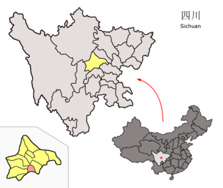
Xinjin District is a district of the City of Chengdu, the capital of Sichuan, China. It borders the prefecture-level city of Meishan to the south.

Wengyuan is a county in the north of Guangdong Province, China, bordering Jiangxi to the northeast. It is under the administration of Shaoguan City. It has a population of 421,756 in 2019, 99.55% of whom speak Hakka. Yao languages are spoken in some parts of the county. 0.616% of the population belongs to minority ethnic groups, most of them Yao.
Huimin County is a county of northwestern Shandong province, People's Republic of China. It is under the administration of Binzhou City.
Tianyang District is a district in western Guangxi, China. It is under the administration of the prefecture-level city of Baise.

Ziyun Miao and Buyei Autonomous County is a county in the southwest of Guizhou province, China. It is under the administration of the prefecture-level city of Anshun.
Shibing County is a county in the east of Guizhou province, China. It is under the administration of the Qiandongnan Miao and Dong Autonomous Prefecture.
Yuan'an County is a county in the west of Hubei province, People's Republic of China. It is under the administration of the prefecture-level city of Yichang.
Antu County is a county of southeastern Jilin province, Northeast China. It is under the administration of the Yanbian Korean Autonomous Prefecture. Antu is home to Korean and Manchu minorities. In 2020 it had a population of 195,000, of which 17.9% Koreans. It has a border crossing with North Korea at Shuangmufeng (双目峰).

Guangling County is in the northeast of Shanxi province, China. It is under the administration of Datong city. Guangling is a basin surrounded by Taihang Mountains. The temperature ranges from −34.0 to 38.2 °C, with an annual mean of 7.0 °C (44.6 °F). Guangling has nine township level divisions. Famous tourist attractions include: Temple of Water God (水神堂), Temple of Holy Spring (圣泉寺), Zhao Great Wall (赵长城). Local products include: papercut, millet, sunflower seeds, dry Tofu etc.
Tazhong is a town in Qiemo County, Bayingolin Mongol Autonomous Prefecture, Xinjiang. Tazhong administers one community: Tazhong Community. Tazhong was created on July 24, 2015. The population is typically around 20,000, 90% of which are temporary residents.


