El Escorial, or the Royal Site of San Lorenzo de El Escorial, or Monasterio del Escorial, is a historical residence of the King of Spain located in the town of San Lorenzo de El Escorial, 2.06 km (1.28 mi) up the valley from the town of El Escorial and about 45 kilometres northwest of the Spanish capital Madrid. Built between 1563 and 1584 by order of King Philip II, El Escorial is the largest Renaissance building in the world. It is one of the Spanish royal sites and functions as a monastery, basilica, royal palace, pantheon, library, museum, university, school, and hospital.

San Lorenzo de El Escorial, also known as El Escorial de Arriba, is a town and municipality in the Community of Madrid, Spain, located to the northwest of the region in the southeastern side of the Sierra de Guadarrama, at the foot of Mount Abantos and Las Machotas, 47 kilometres (29 mi) from Madrid. It is head of the eponymous judicial party. The settlement is popularly called El Escorial de Arriba, to differentiate it from the neighbouring village of El Escorial, also known as El Escorial de Abajo.

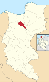
El Escorial is a municipality in the Autonomous Community of Madrid, located 45 km (28 mi) northwest of the Spanish capital Madrid. It belongs to the comarca of Cuenca del Guadarrama. Its population in 2009 was 14,979.
Concepción Huista is a town and municipality in the Guatemalan department of Huehuetenango.

Juan de Herrera was a Spanish architect, mathematician and geometrician.
El Retén is a town and municipality of the Magdalena Department in northern Colombia.

Valdelavilla is an uninhabited village in the Spanish province of Soria, in the autonomous community of Castile-León. A former municipality, it is located in the region of Tierras Altas and in the judicial district of Soria. It belongs to the municipality of San Pedro Manrique.

Husillos is a municipality located in the province of Palencia, Castile and León, Spain. According to the 2004 census (INE), the municipality had a population of 208 inhabitants.

The Herrerian style of architecture was developed in Spain during the last third of the 16th century under the reign of Philip II (1556–1598), and continued in force in the 17th century, but transformed by the Baroque style of the time. It corresponds to the third and final stage of Spanish Renaissance architecture, whose dominant trend had been towards austerity and minimal decoration. The ornate Plateresque style had given way to classical Purism in the second third of the 16th century. Purism in turn had given way to the geometric simplicity of the Herrerian style.
The Battle of Morella, southwest of Tortosa, was fought between Sancho Ramírez, King of Aragon and Navarre, and Yusuf al-Mu'tamin, King of Zaragoza, while the former was engaged in a campaign of conquest against the latter. All surviving sources for the battle are either later by a generation or literary in character, and they are confused on the chronology and dating of the event. The encounter was a defeat for Sancho and sparked a brief reversal of fortunes in the Navarro-Aragonese Reconquista. The Castilian hero, Rodrigo Díaz de Vivar, El Cid, was a general for al-Mu'tamin at the time. According to the Aragonese Crónica de San Juan de la Peña (c.1370), Sancho later sought out El Cid, who had also defeated his father in the Battle of Graus (1063), and defeated him in the year 1088. However, the Crónica is the only source mentioning such an encounter and, as it was written three hundred years later, most leading scholars give no credence to this claim, which was probably intended to justify the prerogatives of Peter IV of the Crown of Aragon.

The Castle of Villaviciosa de Odón is a palace-fortress complex found in the small town of the same name near Madrid, Spain. It is located on Madrid Avenue.

Santa María de la Alameda is a municipality of the Community of Madrid, Spain. It is linked to the city of Madrid and the town of El Escorial by regular train services. A popular weekend and holiday destination, Santa Maria is popular with anglers, hunters, walkers and outdoors enthusiasts.

Settat is a province of Morocco in the Casablanca-Settat Region. The province had a population of 956,904 people in 2004.

The Casita del Infante is a historic building in San Lorenzo de El Escorial, Spain. It was constructed as a private home for the Infante Gabriel of Spain, hence its name. The small residence was built in the late 18th century during the reign of his father, Charles III of Spain.
Tlaxco Municipality is a municipality in Puebla in southeastern Mexico.

The Casita del Príncipe is an eighteenth-century house near the Royal Palace of El Pardo which is set in a hunting estate north of Madrid.
El Bongo is a corregimiento in Bugaba District, Chiriquí Province, Panama. It has a land area of 41.9 square kilometres (16.2 sq mi) and had a population of 1,448 as of 2010, giving it a population density of 34.6 inhabitants per square kilometre (90/sq mi). It was created by Law 10 of March 7, 1997; this measure was complemented by Law 5 of January 19, 1998 and Law 69 of October 28, 1998. Its population as of 2000 was 1,406.
El Harino is a corregimiento in La Pintada District, Coclé Province, Panama. It has a land area of 252.1 square kilometres (97.3 sq mi) and had a population of 5,455 as of 2010, giving it a population density of 21.6 inhabitants per square kilometre (56/sq mi). Its population as of 1990 was 6,520; its population as of 2000 was 6,990.
El Pedregoso is a corregimiento in Pesé District, Herrera Province, Panama with a population of 1,386 as of 2010. Its population as of 1990 was 1,214; its population as of 2000 was 1,311.
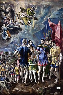
The Martyrdom of Saint Maurice is a 1580-1582 painting by El Greco in the Real Monasterio de San Lorenzo de El Escorial near Madrid.