Eselsweg

Last updated • 3 min readFrom Wikipedia, The Free Encyclopedia
Eselsweg
Eselsweg near Rohrbrunn.JPG
Eselsweg near Rohrbrunn
Length111 km (69 mi)
LocationNaturpark Hessischer Spessart,
Naturpark Bayerischer Spessart Germany
Trailheads Schlüchtern, Großheubach, numerous places in between
UseHiking
Elevation gain/loss2,071 metres (6,790 ft) gain in; 2,078 metres (6,820 ft) gain out
Highest point525 m above sea level (east of Bad Orb)
Lowest point212 m above sea level (western start near Schlüchtern)
Waymark black "E" on white
Surface natural paths (35%),
gravel on forest roads (60%), tarmac (5%)
Websitewww.spessartbund.de

The Eselsweg (English: "donkey trail") is a long-distance hiking trail that follows an ancient trade route through the Mittelgebirge Spessart, in the states of Hesse and Bavaria, Germany. It is 111 km long and leads from Schlüchtern in the valley of the Kinzig river to Großheubach on the river Main. The trail follows an ancient trade route on which donkey caravans used to transport salt, thus giving rise to the name. [1]

Contents

History

The historic road Eselsweg has likely been in use since prehistoric times. It may have connected Celtic circular ramparts, found for example at Bürgstadt and Miltenberg to similar places near the Kinzig, such as the Alteburg  [ de ]. Since in pre-modern times the valleys of the Spessart were often swampy and water-logged, the path stuck to the higher elevations. This route also avoided the need for constant climbing into and out of the river valleys. The route's name derives from the caravans of donkeys used in the Middle Ages to transport salt from Orb to Miltenberg, where it was either loaded on ships or carried on by land. Miltenberg was an important toll station set up by the Archbishop of Mainz. The Eselsweg was first mentioned in 1339 as "Eßelspfadt". [1] [2]

Route

Dr.-Kihn-Platz where Eselsweg and Birkenhainer Strasse meet Karl Kihn Platz.jpg
Dr.-Kihn-Platz where Eselsweg and Birkenhainer Strasse meet
Official detour sign on the Eselsweg near Heigenbrucken due to forestry work conducted by Deutsche Bahn, 2013 Detour Sign Eselsweg.JPG
Official detour sign on the Eselsweg near Heigenbrücken due to forestry work conducted by Deutsche Bahn, 2013
Schloss Luitpoldshohe near Rohrbrunn Schloss Luitpoldshohe.JPG
Schloss Luitpoldshöhe near Rohrbrunn

The modern hiking trail mostly follows the historic route and crosses the Spessart as a high route which sticks to the peaks and ridges and avoids the valleys and villages. It is maintained and signposted by the Spessartbund  [ de ] with a black "E" on white. [3]

The Eselsweg hiking trail starts at the train station of Schlüchtern, Main-Kinzig. It then climbs from the Kinzig valley into the Spessart hills and goes roughly southwest and then south. Near the Wiesbüttmoor  [ de ], it reaches the Bavarian border and follows it west before turning south again, entering the Landkreis Aschaffenburg . In this area, the Eselsweg also touches another ancient trade route, the Birkenhainer Strasse . The two trails run alongside each other to the Dr.-Kihn-Platz, where they part ways. The Eselsweg continues to lead mostly in a southerly direction, until it crosses the Autobahn 3 at Weibersbrunn before looping west and south back to the Autobahn at Rohrbrunn, a possible location of the inn that inspired a story by Wilhelm Hauff and the movie The Spessart Inn . The trail passes a hunting lodge used by Luitpold, Prince Regent of Bavaria, Schloss Luitpoldshöhe  [ de ], and snakes southwards and southwest, entering the Landkreis Miltenberg . It reaches the Main valley at the Kloster Engelberg , above Großheubach and then leads down over 600 steps (Engelsstaffeln) into the town. [1] [4] :37–38 [5] :77

For most of its length after the initial climb the trail stays at an elevation between 400 m and 500 m and sports few significant climbs. It mostly passes through mixed coniferous forest. The only villages the trail directly touches are: Lettgenbrunn (a part of Jossgrund) and Weibersbrunn. It also passes quite close to the villages of Flörsbach (a part of Flörsbachtal) and Wildensee (a part of Eschau) as well as to Heigenbrücken, a larger town. [1] [6] :72

Related Research Articles

Aschaffenburg is a Landkreis (district) in Bavaria, Germany. It is bounded by the districts of Darmstadt-Dieburg, Offenbach, Main-Kinzig, the districts Main-Spessart and Miltenberg, and the town of Aschaffenburg.

<span class="mw-page-title-main">Spessart</span>

Spessart is a Mittelgebirge, a range of low wooded mountains, in the States of Bavaria and Hesse in Germany. It is bordered by the Vogelsberg, Rhön and Odenwald. The highest elevation is the Geiersberg at 586 metres above sea level.

<span class="mw-page-title-main">Schönrain Priory</span>

Schönrain Priory was a house of the Benedictine Order located near Lohr in the Spessart, in Bavaria in southern Germany. Few signs of the monastic buildings are visible today. The ruins that remain mostly consist of later additions when the structure served as a temporal dwelling and foresters' lodge.

<span class="mw-page-title-main">Bad Soden-Salmünster</span> Town in Hesse, Germany

Bad Soden-Salmünster is a town in the Main-Kinzig district, in Hesse, Germany. It is situated on the river Kinzig, between Fulda and Hanau. It has a population of around 13,000.

<span class="mw-page-title-main">Klingenberg am Main</span> Town in Bavaria, Germany

Klingenberg am Main is a town in the Miltenberg district in the Regierungsbezirk of Lower Franconia (Unterfranken) in Bavaria, Germany. It has a population of around 6,200 and is located on both banks of the river Main.

<span class="mw-page-title-main">Schlüchtern</span> Town in Hesse, Germany

Schlüchtern is a town in the Main-Kinzig district, in Hessen, Germany. It is located on the river Kinzig, approximately 30 km southwest of Fulda. Schlüchtern has a population close to 16,000.

<span class="mw-page-title-main">Bad Orb</span> Town in Hesse, Germany

Bad Orb is a spa town in the Main-Kinzig-Kreis district of Hesse, Germany. It is situated 32 kilometres (20 mi) east of Hanau between the forested hills of the Spessart. Bad Orb has a population of over 10,000. Its economy is dominated by the health and tourism sectors.

<span class="mw-page-title-main">Rothenbuch</span> Municipality in Bavaria, Germany

Rothenbuch is a community in the Aschaffenburg district in the Regierungsbezirk of Lower Franconia (Unterfranken) in Bavaria, Germany. It has a population of around 1,700.

<span class="mw-page-title-main">Weibersbrunn</span> Municipality in Bavaria, Germany

Weibersbrunn is a community with a population of close to 2,000 in the Aschaffenburg district in the Regierungsbezirk of Lower Franconia (Unterfranken) in Bavaria, Germany.

<span class="mw-page-title-main">Bürgstadt</span> Municipality in Bavaria, Germany

Bürgstadt is a market community in the Miltenberg district in the Regierungsbezirk of Lower Franconia (Unterfranken) in Bavaria, Germany and the seat of the Verwaltungsgemeinschaft of Erftal. Bürgstadt is a winegrowing community in the wine region of Franken. It has a population of around 4,300.

<span class="mw-page-title-main">Großheubach</span> Municipality in Bavaria, Germany

Großheubach is a market community in the Miltenberg district in the Regierungsbezirk of Lower Franconia (Unterfranken) in Bavaria, Germany.

<span class="mw-page-title-main">Biebergemünd</span> Municipality in Hesse, Germany

Biebergemünd is a municipality in the Main-Kinzig district, in Hesse, Germany. It has a population of over 8,000 and lies in the wooded hills of the Spessart.

<span class="mw-page-title-main">Flörsbachtal</span> Municipality in Hesse, Germany

Flörsbachtal is a municipality in the Main-Kinzig district, in Hesse, Germany. It has a population close to 2,400. Flösbachtal contains both the oldest parish and the youngest settlement established in the Spessart hills. Located within the municipal territory is the Hermannskoppe, the highest elevation in the Hessian part of the Spessart and the Wiesbüttmoor, a rare hanging bog.

<span class="mw-page-title-main">Flieden–Gemünden railway</span>

The Flieden–Gemünden railway is a double track electrified railway line from Fulda, Flieden and Schlüchtern via Jossa to Gemünden am Main. The northern part of the line is in the German state of Hesse and it crosses into Bavaria south of Jossa.

<span class="mw-page-title-main">First Schafalpenkopf</span>

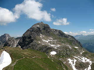
The First Schafalpenkopf or Southwestern Schafalpenkopf is a 2,272-metre-high mountain in the Allgäu Alps. It is part of the Schafalpenköpfe and the Mindelheim Klettersteig.

<span class="mw-page-title-main">Jossa (Sinn)</span> River in Hesse, Germany

Jossa is a river of Hesse, Germany. It is a tributary of the Sinn, which in turn flows into the Franconian Saale shortly before the latter discharges into the Main at Gemünden am Main.

<span class="mw-page-title-main">Bregenz Forest Mountains</span>

The Bregenz Forest Mountains, also the Bregenzerwald Mountains, are a range of the Northern Limestone Alps and Eastern Alps, named after the town of Bregenz. The Bregenz Forest Mountains are located entirely in the Austrian state of Vorarlberg.

<span class="mw-page-title-main">Birkenhainer Straße</span> Long-distance hiking trail in Germany

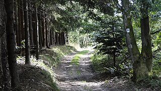
The Birkenhainer Straße is a long-distance hiking trail that follows an ancient trade route through the Mittelgebirge Spessart, in the states of Hesse and Bavaria, Germany. It is 71 km long and leads from Hanau to Gemünden am Main, cutting across the so-called Mainviereck, a large loop of the river Main. The trail follows an ancient trade route which in the Middle Ages was an important road for moving troops and for long-distance trade. The Birkenhainer Straße was a part of the link between Nuremberg and Antwerp. Its origins may lie back as far as the Neolithic period. The name likely derives from a prominent copse of birch trees that used to exist near the road at Geiselbach (Hesse).

<span class="mw-page-title-main">Engelberg Abbey (Bavaria)</span>

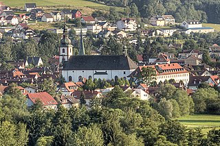
Kloster Engelberg is a Franciscan monastery in Grossheubach in Bavaria, Germany. In the past, a pilgrimage dedicated to a figure of Mary, documented as far back as 1406, was administered by the Capuchins after 1630. Following secularization in the early 19th century, the Capuchins eventually left and the Franciscan order took over the abbey and caring for the pilgrims. The abbey is (partially) open to the public.

<span class="mw-page-title-main">Weiherkopf</span>

The Weiherkopf is a summit in the Hörner Group within the Allgäu Alps in Bavaria, Germany, with a height of 1,665 m.

References

  1. 1 2 3 4 "Eselsweg (German)". Deutscher Wanderverband. Retrieved 3 September 2015.
  2. "Eselsweg (German)". Spessartbund. Retrieved 3 September 2015.
  3. "Eselsweg (German)". Naturpark Spessart. Archived from the original on 26 July 2015. Retrieved 3 September 2015.
  4. Thiemig, Karl, ed. (1972). Grieben Reiseführer, Band 137: Spessart (German). Grieben Verlag, München.
  5. Tubbesing, Ulrich (2010). Rother Wanderführer Spessart (German). Bergverlag Rother, München. ISBN   978-3-7633-4269-3.
  6. Frosch, Norbert (2010). Kompass Wanderführer Spessart (German). Kompass Karten GmbH, Innsbruck. ISBN   978-3-85026-219-4.

Further reading