
Llanwrtyd Wells is a small town and community in mid Powys, Wales, in the historic county of Brecknockshire (Breconshire) on the Afon Irfon. The town is on the A483 between Llandovery and Builth Wells and is located near the pass between the Tywi and Irfon valleys. It is the smallest town in the United Kingdom.

St Fagans National Museum of History, commonly referred to as St Fagans after the village where it is located, is an open-air museum in Cardiff chronicling the historical lifestyle, culture, and architecture of the Welsh people. The museum is part of the wider network of Amgueddfa Cymru – National Museum Wales.

The River Frome, once also known as the Stroudwater, is a small river in Gloucestershire, England. It is to be distinguished from another River Frome in Gloucestershire, the Bristol Frome, and the nearby River Frome, Herefordshire. The river is approximately 25 miles (40 km) long.

Llandysul is a small town and community in the county of Ceredigion, Wales. As a community it consists of the townships of Capel Dewi, Horeb, Pontsian, Pren-gwyn, Tregroes, Rhydowen and the village of Llandysul itself. Llandysul lies in south Ceredigion in the valley of the River Teifi and is visited for its fishing and canoeing. The community had a population of 2,732, as of 2011. The village itself a population of 1484.

Llangain is a village and community in Carmarthenshire, in the south-west of Wales. Located to the west of the River Towy, and south of the town of Carmarthen, the community contains three standing stones, and two chambered tombs as well as the ruins of 15th century great house, Castell Moel. In 2001 the community's population was recorded at 574, decreasing slightly to 573 at the 2011 census.

The Leeds Industrial Museum at Armley Mills is a museum of industrial heritage located in Armley, near Leeds, in West Yorkshire, Northern England. The museum includes collections of textile machinery, railway equipment and heavy engineering amongst others.

Penmachno is a village in the isolated upland Machno valley, 4 miles (6 km) south of Betws-y-Coed in the county of Conwy, North Wales. The B4406 road runs through part of the village. The village is at the confluence of the Glasgwm and Machno rivers. It has a five-arched, stone bridge dating from 1785. The village has been referred to as Pennant Machno, Llandudclyd and Llan dutchyd in historical sources.

Llys Rhosyr, also known as "Cae Llys", is an archaeological site near Newborough in Anglesey; the ruins of a pre-Edwardian commotal court. The Welsh word llys originally referred to an enclosed open-air space but gradually took on the meaning of a place where legal proceedings took place and was gradually extended to refer to royal "courts".

Nolton and Roch is a community in the Hundred of Roose, Pembrokeshire, Wales. The community consists essentially of the villages of Nolton and Roch and a number of hamlets including Cuffern and Druidston. The western part of the community is in the Pembrokeshire Coast National Park. Its population (2001) was 746, increasing to 825 at the 2011 census.

Dre-fach Felindre is a village in Carmarthenshire, West Wales. It is located four miles south-east of Newcastle Emlyn. It lies at the confluence of three fast-flowing streams, the Nant Bargod, Nant Esgair and Nant Brân, where their steep-sided valleys open out into the Teifi Valley. In the 19th and early 20th century it was an important centre for the woollen industry and was given the epithet, "the Huddersfield of Wales". As the population increased, the villages of Dre-fach and Felindre extended and merged to form the present community.
Blarney Woollen Mills was built in 1823. It was used mainly for spinning and weaving wool. The mill briefly closed for two years between 1973 and 1975, after which it was re-opened as an Irish heritage shop. It is located in the village of Blarney, County Cork, Ireland.

St Teilo's Church is a historic building originally located at Llandeilo Tal-y-Bont near Pontarddulais and now reconstructed at St Fagans National History Museum in Cardiff, Wales.

Melin Bompren is a water-powered corn mill, originally located at Cross Inn, Cardiganshire, Wales, but now at the St Fagans National History Museum, Cardiff.

Gwalia Stores is a retail premises originally built at Ogmore Vale, Glamorgan, in 1880 and currently located at St Fagans National History Museum, Cardiff, Wales.

Hendre'r Ywydd Uchaf is an early 16th-century cruck house, originally constructed near Llangynhafal, Denbighshire, and now located at St Fagans National History Museum in Cardiff, Wales. One of the interior wooden beams has been dated to the year 1508, using dendrochronology. The house has five bays, two of which would have been used for livestock, and an open hearth. It was designated a Grade II listed building on 10 June 1977.
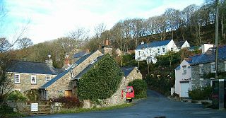
Middle Mill is a small settlement on the River Solva in the parish of Whitchurch, Pembrokeshire, Wales, approximately 1 mile upstream from the coastal village of Solva.

The woollen industry in Wales was at times the country's most important industry, though it often struggled to compete with the better-funded woollen mills in the north of England, and almost disappeared during the 20th century. There is continued demand for quality Welsh woollen products.
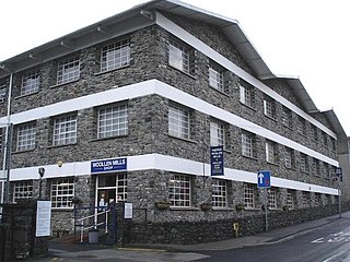
Trefriw Woollen Mills is a woollen mill in the village of Trefriw, Conwy, in northern Wales, that has been operating since around 1825.

Cambrian Woollen Mill, just north of Llanwrtyd Wells, Powys, is one of the few remaining operational woollen mills in Wales. It is known for its line of Welsh tartans. The building dates to 1820.
