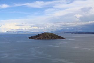
Titicaca is a large, deep, freshwater lake in the Andes on the border of Bolivia and Peru, often called the "highest navigable lake" in the world. By volume of water and by surface area, it is the largest lake in South America.

Puno is a city in southeastern Peru, located on the shore of Lake Titicaca. It is the capital city of the Puno Region and the Puno Province with a population of approximately 140,839. The city was established in 1668 by viceroy Pedro Antonio Fernández de Castro as capital of the province of Paucarcolla with the name San Juan Bautista de Puno. The name was later changed to San Carlos de Puno, in honor of king Charles II of Spain. Puno has several churches dating back from the colonial period; they were built to service the Spanish population and evangelize the natives.

Puno is a department in southeastern Peru. It is bordered by Bolivia on the east, the departments of Madre de Dios on the north, Cusco and Arequipa on the west, Moquegua on the southwest, and Tacna on the south. Its capital is the city of Puno, which is located on Lake Titicaca in the geographical region known as the Altiplano or high sierra.

Taquile is an island on the Peruvian side of Lake Titicaca 45 km offshore from the city of Puno. About 2,200 people live on the island, which is 5.5 by 1.6 kilometres in size, with an area of 5.72 km2 (2.21 sq mi). The highest point of the island is 4,050 metres above sea level and the main village is at 3,950 metres. The inhabitants, known as Taquileños, speak Puno Quechua.

The Uru or Uros are an indigenous people of Peru and Bolivia. They live on an approximate and still growing 120 self-fashioned floating islands in Lake Titicaca near Puno. They form three main groups: the Uru-Chipaya, Uru-Murato, and Uru-Iruito. The Uru-Iruito still inhabit the Bolivian side of Lake Titicaca and the Desaguadero River.

Puno is a province in the Puno Region, in southeastern Peru. It borders the provinces of Huancane, San Román, El Collao and the Moquegua Region's province of General Sánchez Cerro. Its capital is the city of Puno, which is located at the edge of Lake Titicaca, the world's highest navigable lake. It is the economic powerhouse of the region.

Eliodoro Camacho is a province in the La Paz Department in Bolivia situated at Lake Titicaca. Its seat is Puerto Acosta.

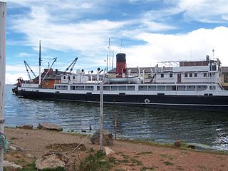
Yavari is a ship commissioned by the Peruvian government in 1861 for use on Lake Titicaca. She is named after the Javary River in the Loreto Region of Peru, bordering the Amazonas State (Brazil).

Yunguyo is a town in the Puno Region in southeastern Peru. It is the capital of Yunguyo Province and Yunguyo District. It has a population of 12,625.

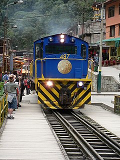
PeruRail is a railway operator providing tourist, freight, and charter services in southern Peru. It was founded in 1999 by 2 Peruvian entrepreneurs and British company Sea Containers.
Waru Waru is an Aymara term for the agricultural technique developed by pre-Hispanic people in the Andes region of South America from Colombia to Bolivia; this regional agricultural technique is also referred to as camellones in Spanish. Functionally similar agricultural techniques have been developed in other parts of the world, all of which fall under the broad category of raised field agriculture.
Guaqui is a railhead and port in Bolivia on Lake Titicaca. A ferry connects with the Peruvian railhead and port on Puno.
Lake Lagunillas is a lake in the Andes of far southeastern Peru. Lagunillas is at an altitude of about 4,250 m (13,900 ft) and it is located just northwest of Lake Saracocha. These two lakes are part of the system drained by the Coata River, which flows in a generally easterly direction until entering westernmost Lake Titicaca, about 50 km (30 mi) from Lake Lagunillas as the crow flies.

BAP Puno is a Peruvian Navy hospital ship on Lake Titicaca. Until 1976 she was called Yapura.

SS Ollanta, built in England in 1931, is a steamship on Lake Titicaca in Peru.

Ticonata or Tikonata is an island on the Peruvian side of Lake Titicaca. It is located in the Puno Region, Puno Province, Capachica District, between the peninsula Capachica in the east and the island Amantani in the west.

Asiru Phat'jata is a hill in Peru, situated at a height of about 3,895 metres (12,779 ft). It is located in the Puno Region, Yunguyo Province, Yunguyo District. Asiru Phat'jata lies near Lake Titicaca at the road which connects Yunguyo and Puno, south of the village Asiru Phat'jata (Acero Patjata) and north of the mountain Qhapiya.

Khapia is a mountain in Peru, possibly an extinct volcano, situated at a height of about 4,809 metres (15,778 ft). It is located in the Puno Region, Chucuito Province, in the districts Pomata and Zepita, and in the Yunguyo Province, in the districts Cuturapi, Copani and Yunguyo. The mountain lies near Lake Titicaca at the road which connects Yunguyo and Puno, south of the hill Asiru Phat'jata.

Glorious National School of Saint Charles was created by decree of Simón Bolivar on 7 August 1825 in Puno, Peru.


