
An estuary is a partially enclosed coastal body of brackish water with one or more rivers or streams flowing into it, and with a free connection to the open sea.
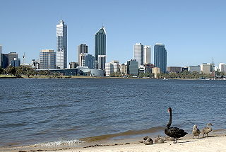
The Swan River is a river in the south west of Western Australia. Its Aboriginal Noongar name is the Derbarl Yerrigan. The river runs through the metropolitan area of Perth, Western Australia's capital and largest city.

A marsh is a wetland that is dominated by herbaceous rather than woody plant species. Marshes can often be found at the edges of lakes and streams, where they form a transition between the aquatic and terrestrial ecosystems. They are often dominated by grasses, rushes or reeds. If woody plants are present they tend to be low-growing shrubs, and then sometimes called carrs. This form of vegetation is what differentiates marshes from other types of wetland such as swamps, which are dominated by trees, and mires, which are wetlands that have accumulated deposits of acidic peat.

The littoral zone or nearshore is the part of a sea, lake, or river that is close to the shore. In coastal environments, the littoral zone extends from the high water mark, which is rarely inundated, to shoreline areas that are permanently submerged. The littoral zone always includes this intertidal zone, and the terms are often used interchangeably. However, the meaning of littoral zone can extend well beyond the intertidal zone.

A body of water or waterbody is any significant accumulation of water, generally on a planet's surface. The term most often refers to oceans, seas, and lakes, but it includes smaller pools of water such as ponds, wetlands, or more rarely, puddles. A body of water does not have to be still or contained; rivers, streams, canals, and other geographical features where water moves from one place to another are also considered bodies of water.
The Margaret River is a river in southwest Western Australia. In a small catchment, it is the eponym of the town and tourist region of Margaret River.

The Canning River is a major tributary of the Swan River in south western Western Australia.

The Blackwood River is a major river and catchment in the South West of Western Australia.

The Swan Coastal Plain in Western Australia is the geographic feature which contains the Swan River as it travels west to the Indian Ocean. The coastal plain continues well beyond the boundaries of the Swan River and its tributaries, as a geological and biological zone, one of Western Australia's Interim Biogeographic Regionalisation for Australia (IBRA) regions. It is also one of the distinct physiographic provinces of the larger West Australian Shield division.
The Greenough River is a river in the Mid West region of Western Australia.
The Peel-Harvey Estuarine System is a natural estuarine system that lies roughly parallel to the coast of Western Australia and south of the town of Mandurah. The strip of land between the Indian Ocean and the estuarine system carries the Old Coast Road and to the east is the Forrest Highway which is the main thoroughfare between Perth and the coastal towns of the south west corner of the state including Bunbury and Busselton.

The Barker Inlet is a tidal inlet of the Gulf St Vincent in Adelaide, South Australia, named after Captain Collet Barker who first sighted it in 1831. It contains one of the southernmost mangrove forests in the world, a dolphin sanctuary, seagrass meadows and is an important fish and shellfish breeding ground. The inlet separates Torrens Island and Garden Island from the mainland to the East and is characterized by a network of tidal creeks, artificially deepened channels, and wide mudflats. The extensive belt of mangroves are bordered by samphire saltmarsh flats and low-lying sand dunes, there are two boardwalks, and ships graveyards in Broad Creek, Angas Inlet and the North Arm.

The Murray River is a river in the southwest of Western Australia. It played a significant part in the expansion of settlement in the area south of Perth after the arrival of British settlers at the Swan River Colony in 1829.
Leschenault Estuary is an estuarine lagoon that lies to the north of Bunbury, Western Australia. It had in the past met the Indian Ocean at the Leschenault Inlet, but that has been altered by harbour works for Bunbury, and the creation of The Cut north of the historical inlet location.

Chapman River is a river in the Mid West region of Western Australia.
A standing crop is the total dried biomass of the living organisms present in a given environment.

Acanthopagrus butcheri, the black bream but also commonly known as the southern black bream, southern bream and blue-nosed bream, is a species of marine and freshwater fish of the porgy family, Sparidae. It is a deep-bodied fish, occasionally confused with other similar species that occur within its range, but is generally distinguished from these species by a lack of yellow ventral and anal fins. Southern black bream are endemic to Australia, inhabiting the southern coast from Shark Bay in Western Australia to Mallacoota, Victoria, as well as Tasmania.
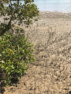
Australia has approximately 11,500 km2 of mangroves, primarily on the northern and eastern coasts of the continent. Areas where mangroves occur include the intertidal zone of tropical, subtropical and protected temperate coastal rivers, estuaries, bays and marine shorelines. Less than 1% of Australia's total forest area is mangrove forest.
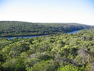
Estuaries of Australia are features of the Australian coastline. They are linked to tides, river mouths and coastal features and conditions. In many cases the features of estuaries are also named inlets.

Adelaide Dolphin Sanctuary is a marine protected area in the Australian state of South Australia located on the east coast of Gulf St Vincent in and adjoining the north-western part of the Adelaide metropolitan area and which was established in 2005 for the protection of a resident population of Indo-Pacific bottlenose dolphins .