Related Research Articles

The term Pool of Siloam refers to a number of rock-cut pools, located outside the walls of the Old City of Jerusalem to the southeast. The pools were fed by the waters of the Gihon Spring, carried there by the Siloam Tunnel.

Bethlehem of Galilee or Bethlehem-in-the-Galilee is a moshav in northern Israel. Located in the Galilee near Kiryat Tivon, around 10 kilometres north-west of Nazareth and 30 kilometres east of Haifa, it falls under the jurisdiction of the Jezreel Valley Regional Council. As of 2022 it had a population of 824.

Al-Tall, was a Palestinian village 14 km northeast of Acre in the British Mandate District of Acre. Depopulated as a result of military assault and capture during the 1947-1948 Civil War in Mandatory Palestine as part of Operation Operation Ben-Ami by the Carmeli Brigade of the Israel Defense Forces.
Ein Gedi, also spelled En Gedi, meaning "spring of the kid", is an oasis, an archeological site and a nature reserve in Israel, located west of the Dead Sea, near Masada and the Qumran Caves. Ein Gedi, a kibbutz, was established nearby in 1954.

The Copper Scroll (3Q15) is one of the Dead Sea Scrolls found in Cave 3 near Khirbet Qumran, but differs significantly from the others. Whereas the other scrolls are written on parchment or papyrus, this scroll is written on metal: copper mixed with about 1 percent tin, although no metallic copper remained in the strips; the action of the centuries had been to convert the metal into brittle oxide. The so-called 'scrolls' of copper were, in reality, two separated sections of what was originally a single scroll about 2.4 metres (7.9 ft) in length. Unlike the others, it is not a literary work, but a list of 64 places where various items of gold and silver were buried or hidden. It differs from the other scrolls in its Hebrew, its orthography, palaeography and date.

Betar, also spelled Beitar, Bethar or Bether, was an ancient Jewish town in the Judaean Mountains. Continuously inhabited since the Iron Age, it was the last standing stronghold of the Bar Kokhba revolt, and was destroyed by the Imperial Roman Army under Hadrian in 135 CE.

Ein Karem is a historic mountain village southwest of Jerusalem, presently a neighborhood in the outskirts of the modern city, within the Jerusalem District. It is the site of the Hadassah Medical Center.

Balm of Gilead was a rare perfume used medicinally that was mentioned in the Hebrew Bible and named for the region of Gilead, where it was produced. The expression stems from William Tyndale's language in the King James Bible of 1611 and has come to signify a universal cure in figurative speech. The tree or shrub producing the balm is commonly identified as Commiphora gileadensis. However, some botanical scholars have concluded that the actual source was a terebinth tree in the genus Pistacia.

Ecclesiastes Rabbah or Kohelet Rabbah is an aggadic commentary on Ecclesiastes, included in the collection of the Midrash Rabbot. It follows the biblical book verse by verse, only a few verses remaining without commentary.
Bayt ʿIṭāb was a Palestinian Arab village located in the Jerusalem Subdistrict. The village is believed to have been inhabited since the biblical period. An ancient tunnel which led to the village spring is associated with the story of Samson. Both during and after its incorporation into Crusader fiefdoms in the 12th century, its population was Arab. Sheikhs from the Lahham family clan, who were associated with the Qays tribo-political faction, ruled the village during Ottoman era. In the 19th century, this clan controlled 24 villages in the vicinity. The homes were built of stone. The local farmers cultivated cereals, fruit trees and olive groves and some engaged in livestock breeding.
Teqoa is a Palestinian town in the Bethlehem Governorate, located 12 km (7.5 mi) southeast of Bethlehem in the West Bank. The town is built adjacent to the biblical site of Tekoa, now Khirbet Tuqu', from which it takes its name. Today's town includes three other localities: Khirbet ad-Deir, al-Halkoom, and Khirbet Teqoa. According to the Palestinian Central Bureau of Statistics (PCBS), Teqoa had a population of 8,767 in 2017.

Solomon's Pools are three ancient reservoirs located in the south-central West Bank, immediately to the south of al-Khader, about 3.5 kilometres (2.2 mi) southwest of Bethlehem, near the road to Hebron. The pools are located in Area A of the West Bank under the control of the Palestinian National Authority.
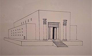
Solomon's Temple, also known as the First Temple, was a biblical Temple in Jerusalem believed to have existed between the 10th and 6th centuries BCE. Its description is largely based on narratives in the Hebrew Bible, in which it was commissioned by biblical king Solomon before being destroyed during the Siege of Jerusalem by Nebuchadnezzar II of the Neo-Babylonian Empire in 587 BCE. No remains of the destroyed temple have ever been found. Most modern scholars agree that the First Temple existed on the Temple Mount in Jerusalem by the time of the Babylonian siege, and there is significant debate among scholars over the date of its construction and the identity of its builder.

Ma'ayan Harod or Ain Jalut is an all-year spring in the Harod Valley on the northwest corner of Mount Gilboa, that was the location of the 13th-century Battle of Ain Jalut. This was a major turning point in world history that saw the Mamluks inflict the first of two defeats on the Mongols that ultimately halted their invasion of the Levant and Egypt.

The Mosaic of Reḥob, is a late 3rd–6th century CE mosaic discovered in 1973. The mosaic, written in late Mishnaic Hebrew, describes the geography and agricultural rules of the local Jews of the era. It was inlaid in the floor of the foyer or narthex of an ancient synagogue near Tel Rehov, 4.5 kilometres (2.8 mi) south of Beit She'an and about 6.5 kilometres (4.0 mi) west of the Jordan River. The mosaic contains the longest written text yet discovered in any Hebrew mosaic in Israel, and also the oldest known Talmudic text.
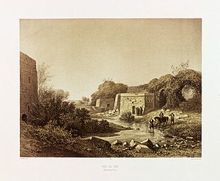
Ras el Ain is a place abounding with immense fountains, with reservoirs and aqueducts 6 kilometers (3.7 mi) south of Tyre, and ca. 77 kilometers (48 mi) south of Beirut, in the South Governorate (Liban-Sud), in the municipality of Batouliyat. The place lies in a very green and fertile plain, about one kilometer from the sea coast. It is a popular tourist destination, owing to its artesian wells fed by underground springs and collected in stone reservoirs that have been maintained through the ages. It has been the main source of water for ancient Tyre since Phoenician days. One of the reservoirs fed the arched aqueducts of the Roman period, and which once stretched all the way to Tyre. Remains of these aqueducts, exhibiting strong and excellent masonry, with round arches and a continuous cornice above them, can still be seen today, and a short stretch of the original aqueduct is still used today in Tyre's present-day waterworks.
Bethmaus, or Beth Maʿon, also called Maon, was a Jewish village during the late Second Temple and Mishnaic periods, and which was already a ruin when Kitchener visited the site in 1877. It was situated upon the hill, directly north-west of the old city of Tiberias, at a distance of one biblical mile, rising to an elevation of 250 metres (820 ft) above sea-level. It is now incorporated within the modern city bounds of Upper Tiberias. The remaining structure built over the site is a Sheikh's Tomb.
Khirbet Kuwayzibah, also Kuzibah, Kueiziba, is an ancient ruin, partly inhabited, in the Hebron Governorate in the West Bank, presently part of Sa'ir. The modern Palestinian village had a population of 1,383 in 2017.
References
- 1 2 International Standard Bible Encyclopedia , 1915 (public domain)
- ↑ Claude Reignier Conder, Tent Work in Palestine (vol. 1), London 1879, pp. 273, 275