Etimoga

Last updated

Etimoga
Location map India Andhra Pradesh EN.svg
Red pog.svg
Etimoga
Location in Andhra Pradesh, India
Coordinates: 15°51′40″N80°53′57″E / 15.8612°N 80.8993°E / 15.8612; 80.8993 Coordinates: 15°51′40″N80°53′57″E / 15.8612°N 80.8993°E / 15.8612; 80.8993
Country India
State Andhra Pradesh
District Krishna
Area
[1]
  Total15.79 km2 (6.10 sq mi)
Elevation
[2]
7 m (23 ft)
Population
 (2011) [3]
  Total4,076
  Density260/km2 (670/sq mi)
Languages
  Official Telugu
Time zone UTC+5:30 (IST)

Etimoga is a village in Krishna district of Indian state of Andhra Pradesh. It is located in Nagayalanka mandal of Machilipatnam revenue division. [1] The village is situated at the mouths of River Krishna, where it empties into Bay of Bengal. [4]

Krishna district District of Andhra Pradesh in India

Krishna district is an administrative district in the Coastal Andhra region of the Indian state of Andhra Pradesh. Machilipatnam is the administrative headquarters and Vijayawada is the most populated city in the district. It has an area of 8,727 km2 (3,370 sq mi) and had a population of 45,29,009 as per 2011 census of India. It is bounded by West Godavari on the east, Bay of Bengal on the South, Guntur and Suryapet districts in the west and a portion of it also borders with the state of Telangana. Krishna District is formed from District of Rajahmundry in 1859, Guntur district was separated from Krishna in 1904 to form Krishna district which was further divided in 1925, to Krishna and West Godavari districts.Krishna district is the most developed district in Andhra Pradesh.

India Country in South Asia

India is a country in South Asia. It is the seventh-largest country by area, the second-most populous country, and the most populous democracy in the world. Bounded by the Indian Ocean on the south, the Arabian Sea on the southwest, and the Bay of Bengal on the southeast, it shares land borders with Pakistan to the west; China, Nepal, and Bhutan to the north; and Bangladesh and Myanmar to the east. In the Indian Ocean, India is in the vicinity of Sri Lanka and the Maldives; its Andaman and Nicobar Islands share a maritime border with Thailand and Indonesia.

Andhra Pradesh State in southern India

Andhra Pradesh is one of the 29 states of India. Situated in the south-east of the country, it is the seventh-largest state in India, covering an area of 160,205 km2 (61,855 sq mi). As per the 2011 census, it is the tenth-most populous state, with 49,386,799 inhabitants. The largest city in Andhra Pradesh is Visakhapatnam. Telugu, one of the classical languages of India, is the major and official language of Andhra Pradesh.

Contents

Demographics

As of 2011 Census of India, Etimoga had a population of 4,076. The total population constitute, 2,111 males and 1,965 females —a sex ratio of 931 females per 1000 males. 373 children are in the age group of 0–6 years, of which 215 are boys and 158 are girls —a ratio of 735 per 1000. The average literacy rate stands at 60.19% with 2,229 literates, significantly lower than the state average of 67.41%. [3] [5]

The decennial Census of India has been conducted 15 times, as of 2011. While it has been undertaken every 10 years, beginning in 1872 under british Viceroy Lord Ripon, the first complete census was taken in 1881. Post 1949, it has been conducted by the Registrar General and Census Commissioner of India under the Ministry of Home Affairs, Government of India. All the censuses since 1951 were conducted under the 1948 Census of India Act. The last census was held in 2011. The next will be held in 2021. Also it was 1st conducted at the time of industrial revolutions too

See also

Related Research Articles

A. Konduru Village in Andhra Pradesh, India

A.Konduru is a village in Krishna district of the Indian state of Andhra Pradesh. It is the mandal headquarters of A.Konduru mandal under Nuzvid revenue division.

Bantumilli Village in Andhra Pradesh, India

Bantumilli is a village in Krishna district of the Indian state of Andhra Pradesh. It is the mandal headquarters of Bantumilli mandal of Machilipatnam revenue division. It is well connected by Road.Its just 28Km from Machilipatnam,50Km from Bhimavaram,34Km from Gudivada. NH214A is connected over this Village.

Challapalli Village in Andhra Pradesh, India

Challapalli, officially known as Challapalle, is a village in Krishna district of the Indian state of Andhra Pradesh. It is located in Challapalli mandal of Machilipatnam revenue division. Challapalli is one of the villages in the mandal to be a part of Andhra Pradesh Capital Region.

Koduru, Krishna district Village in Andhra Pradesh, India

Koduru is a village in Krishna district of the Indian state of Andhra Pradesh.

Nagayalanka Village in Andhra Pradesh, India

Nagayalanka is a village in Krishna district of Indian state of Andhra Pradesh. It is the mandal headquarters of Nagayalanka mandal in Machilipatnam revenue division.

Ibrahimpatnam, Krishna district Census Town in Andhra Pradesh, India

Ibrahimpatnam is a census town in Krishna district of the Indian state of Andhra Pradesh. It is also the mandal headquarters of Ibrahimpatnam mandal. Dr Narla Tata Rao Thermal Power Station, one of the major Thermal power stations of the state is located near the town. Railway Wagon Workshop at Rayanapadu is also located very near to Ibrahimpatnam at a distance of 4 km.

Bommanahal Village in Andhra Pradesh, India

Bommanahal is a village in Anantapur district of the Indian state of Andhra Pradesh. It is the headquarters of Bommanahal mandal in Kalyandurg revenue division.

Chennekothapalle Village in Andhra Pradesh, India

Chennekothapalle is a village in Anantapur district of the Indian state of Andhra Pradesh. It is the headquarters of Chennekothapalle mandal in Dharmavaram revenue division.

Guntupalli, Krishna district Census Town in Andhra Pradesh, India

Guntupalli is a census town in Krishna district of the Indian state of Andhra Pradesh. It is located in Ibrahimpatnam mandal of Vijayawada revenue division. It is a suburb of Vijayawada.

Kollur mandal Mandal in Andhra Pradesh, India

Kollur mandal is one of the 57 mandals in Guntur district of the Indian state of Andhra Pradesh. It is under the administration of Tenali revenue division and the headquarters are located at Kollur.

Machilipatnam mandal Mandal in Andhra Pradesh, India

Machilipatnam mandal is one of the 50 mandals in Krishna district of the Indian state of Andhra Pradesh. It is under the administration of Machilipatnam revenue division and the headquarters are located at Machilipatnam town. The mandal is bounded by Bantumilli, Pedana, Gudur, Ghantasala, Challapalli and Koduru mandals.

Gannavaram mandal Mandal in Andhra Pradesh, India

Gannavaram mandal is one of the 50 mandals in Krishna district of the Indian state of Andhra Pradesh. It is under the administration of Nuzvid revenue division and the headquarters are located at Gannavaram. The mandal is bounded by Agiripalle, Bapulapadu, Unguturu, Vijayawada (rural) and Kankipadu mandals. The mandal is also a part of the Andhra Pradesh Capital Region under the jurisdiction of APCRDA.

Machilipatnam (rural) Village in Andhra Pradesh, India

Machilipatnam (rural) is a village in Krishna district of the Indian state of Andhra Pradesh. It is located on the coast of Bay of Bengal in Machilipatnam mandal of Machilipatnam revenue division.

Amaravathi mandal, Andhra Pradesh Mandal in Andhra Pradesh, India

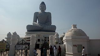
Amaravathi mandal is one of the 57 mandals in Guntur district of the Indian state of Andhra Pradesh. It is under the administration of Guntur revenue division and the headquarters are located at Amaravathi. The mandal is located on the banks of Krishna River, at a distance 27 km from the district headquarters. It is bounded by Atchampet, Krosuru, Pedakurapadu, Tadikonda and Thullur mandals.

Nagayalanka mandal Mandal in Andhra Pradesh, India

Nagayalanka mandal is one of the 50 mandals in Krishna district of the Indian state of Andhra Pradesh. It is under the administration of Machilipatnam revenue division and has its headquarters at Nagayalanka. The mandal is bounded by Avanigadda and Koduru mandals. It lies at the mouths of Krishna River where it empties into Bay of Bengal.

Edurumondi Village in Andhra Pradesh, India

Edurumondi is a village in Krishna district of Indian state of Andhra Pradesh. It is located in Nagayalanka mandal of Machilipatnam revenue division. The village is situated at the mouths of River Krishna, where it empties into Bay of Bengal.

Rayanapadu Village in Andhra Pradesh, India

Rayanapadu is a village in Krishna district of the Indian state of Andhra Pradesh. It is located in Vijayawada (rural) mandal of Vijayawada revenue division. It has the one of the largest wagon workshops of Indian Railways.

Thullur mandal Mandal in Andhra Pradesh, India

Thullur mandal is one of the 57 mandals in Guntur district of the Indian state of Andhra Pradesh. It is under the administration of Guntur Revenue Division and the headquarters are located at Thullur. The mandal is situated on the banks of Krishna River, bounded by Amaravathi, Tadikonda, Tadepalle and Mangalagiri mandals. The mandal is also a part of the new capital city of Andhra Pradesh to be developed. 18 villages from the mandal fall under the jurisdiction of Andhra Pradesh Capital City.

Gampalagudem mandal Mandal in Andhra Pradesh, India

Gampalagudem mandal is one of the 50 mandals in Krishna district of the state of Andhra Pradesh in India. It is under the administration of Nuzvid revenue division and the headquarters are located at Gampalagudem town. The mandal is bounded by Tiruvuru, A. Konduru mandals of Krishna district in Andhra Pradesh and Khammam district of Telangana state.

Chandrala, Mylavaram mandal Village in Andhra Pradesh, India

Chandrala is a village in Krishna district of the Indian state of Andhra Pradesh. It is located in Mylavaram mandal of Vijayawada revenue division. It is one of the villages in the mandal to be a part of Andhra Pradesh Capital Region.

References

  1. 1 2 "District Census Handbook - Krishna" (PDF). Census of India. p. 16,478. Retrieved 4 February 2016.
  2. "Elevation for Etimoga". Veloroutes. Retrieved 3 October 2014.
  3. 1 2 "Census 2011". The Registrar General & Census Commissioner, India. Retrieved 3 October 2014.
  4. "Krishna District mandal maps" (PDF). Census of India. p. 526. Retrieved 21 July 2015.
  5. "Literacy of AP (Census 2011)" (PDF). Official Portal of Andhra Pradesh Government. p. 43. Archived from the original (PDF) on 14 July 2014. Retrieved 3 October 2014.