
Eudora is a city in Douglas County, Kansas, United States, along the Kansas and Wakarusa rivers. As of the 2020 census, the population of the city was 6,408.

The Kansas River, also known as the Kaw, is a meandering river in northeastern Kansas in the United States. It is potentially the southwestern most part of the Missouri River drainage, which is sometimes in turn the northwesternmost portion of the extensive Mississippi River drainage. Its two names both come from the Kanza (Kaw) people who once inhabited the area; Kansas was one of the anglicizations of the French transcription Cansez of the original kką:ze. The city of Kansas City, Missouri, was named for the river, as was later the state of Kansas.

The BNSF Railway Bridge 5.1, also known as the St. Johns Railroad Bridge or the Willamette River Railroad Bridge, is a through truss railway bridge with a vertical lift that spans the Willamette River in Portland, Oregon, United States. Built by the Spokane, Portland and Seattle Railway (SP&S) and completed in 1908, it was originally a swing-span bridge, and its swing-span section was the longest in the world at the time. However, 81 years later the main span was converted from a swing-type to a vertical-lift type, in order to widen the navigation channel. The lift span is one of the highest and longest in the world. The bridge consists of five sections, with the two sections closest to the bank on each side fixed.

Interstate 205 (I-205) is an auxiliary Interstate Highway in the Portland metropolitan area of Oregon and Washington, United States. The north–south freeway serves as a bypass route of I-5 along the east side of Portland, Oregon, and Vancouver, Washington. It intersects several major highways and serves Portland International Airport.
K-10 is a 36.611-mile-long (58.920 km) state highway in the U.S. state of Kansas. It was originally designated in 1929. It is mostly a controlled-access freeway, linking Lawrence to Lenexa. It provides an important toll-free alternate route to Interstate 70. Several scenes for the TV-movie The Day After were filmed on the highway at De Soto in 1982 portraying a mass exodus evacuating the Kansas City area on I-70.
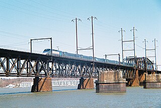
The Amtrak Susquehanna River Bridge is a deck truss bridge that carries the Amtrak Northeast Corridor line across the Susquehanna River between Havre de Grace and Perryville, Maryland. The 4,153.8-foot (1,266.1 m)-long two-track bridge has 17 fixed spans and one swing span across the river's navigation channel. It carries up to 114 daily passenger and freight trains.
The Thousand Islands Parkway (often written as 1000 Islands Parkway) is a scenic parkway in the Canadian province of Ontario. It extends easterly from an interchange with Highway 401 in Gananoque for approximately 40 kilometres (25 mi) to rejoin Highway 401 near the community of Butternut Bay, west of Brockville. The parkway follows the north shore of the St. Lawrence River, and was formerly designated Highway 2S (S for Scenic) until 1970. It passes through the communities of Gray's Beach, Halsteads Bay, Ivy Lea, Darlingside, Rockport, Narrows, La Rue Mills and Mallorytown Landing, as well as providing access to the three inland properties of the Thousand Islands National Park. Highway 137, which meets the parkway near its midpoint, provides access to the Interstate 81 in New York via the Thousand Islands Bridge.
K-32, also known as the Kaw Valley Scenic Highway, is an approximately 32.2-mile-long (51.8 km) east–west state highway in the Kansas City metropolitan area of Kansas. K-32's western terminus is just outside Lawrence at U.S. Route 24 (US-24) and US-40. Its eastern terminus is at US-69, also known as the 18th Street Expressway, in Kansas City. Along the way it intersects several major highways, including K-7 in Bonner Springs as well as Interstate 435 (I-435) and I-635 in Kansas City. In Kansas City, K-32 follows the Turner Diagonal from Kaw Drive to Kansas Avenue. From its western terminus to Bonner Springs, the highway is a two-lane rural highway; the remaining section is a four-lane highway that runs through residential areas.

New York State Route 282 (NY 282) is a north–south state highway located within Tioga County in the Southern Tier of New York in the United States. It extends for 3.48 miles (5.60 km) from the Pennsylvania state line in the town of Nichols, where it connects to Pennsylvania Route 187 (PA 187), to an intersection with NY 17C in the town of Tioga. The route meets Interstate 86 (I-86) and crosses over the Susquehanna River just west of the village of Nichols.
The 23rd Street viaduct, known as the (East) Kansas Avenue Bridge in Kansas, is an automobile crossing of the Kansas River, south of the Rock Island Bridge. Though it is entirely in Kansas City, Kansas, one half leads to Kansas City, Missouri, where Kansas Avenue becomes Avenida César E. Chávez, known as 23rd Street until 1994. The span is 1,395 feet (425 m) long.

The Lewis and Clark Viaduct are two nine span viaducts that cross the Kansas River in the United States. Designed by Waddell and Hedrick, the first viaduct, a four-lane, deck truss bridge, opened to the public on January 29, 1907, the second bridge, also of the deck truss design, opened to the public on November 12, 1962. It rises above the West Bottoms, and several sets of railroad tracks. The 1907 viaduct is notable for being the first roadway bridge to connect Kansas City, Missouri, with Kansas City, Kansas, non-stop all the way across. It is about 1.5 miles (2.4 km) long and carries Interstate 70/U.S. Route 24/U.S. Route 40/U.S. Route 169 (I-70/US 24/US 40/US 169). The I-670 Viaduct serves as a complementary to the viaduct, it was built in 1990 to the south.

US Highway 41 (US 41) is a part of the United States Numbered Highway System that runs from Miami, Florida, to the Upper Peninsula of the US state of Michigan. In Michigan, it is a state trunkline highway that enters the state via the Interstate Bridge between Marinette, Wisconsin, and Menominee, Michigan. The 278.769 miles (448.635 km) of US 41 that lie within Michigan serve as a major conduit. Most of the highway is listed on the National Highway System. Various sections are rural two-lane highway, urbanized four-lane divided expressway and the Copper Country Trail National Scenic Byway. The northernmost community along the highway is Copper Harbor at the tip of the Keweenaw Peninsula. The trunkline ends at a cul-de-sac east of Fort Wilkins State Park after serving the Central Upper Peninsula and Copper Country regions of Michigan.

The U.S. 40 and 59 Bridges are twin multi-beam girder bridges over the Kansas River at Lawrence, Kansas. The west bridge carries two lanes of southbound traffic, connecting to Vermont Street, while the east bridge carries two lanes of northbound traffic from Massachusetts Street. Both bridges converge on the north end to become North 2nd Street. The east bridge is also the third bridge to be built at this location.
The Lecompton Road Bridge is a two-lane girder bridge over Kansas River at Lecompton, Kansas, connecting to the nearby town of Perry. The current bridge, opened in 1970, is the second bridge at this location.
The West Jefferson Avenue–Rouge River Bridge is a historic double-leaf bascule bridge in Wayne County, Michigan, at the border of the cities of Detroit and River Rouge. The bridge carries Jefferson Avenue, a major thoroughfare in Southwest Detroit, over the River Rouge, an important inland route for lake freighters. The bridge was built in 1922, and was listed on the National Register of Historic Places in 2000.

The Indian River Inlet Bridge is a cable-stayed bridge located in Sussex County, Delaware, in the United States. It carries four lanes of Delaware Route 1 over the Indian River Inlet between the Indian River Bay and the Atlantic Ocean. The bridge also carries Delaware Bicycle Route 1 across the inlet. The bridge is within Delaware Seashore State Park between Dewey Beach and Bethany Beach. The Indian River Inlet Bridge is maintained by the Delaware Department of Transportation (DelDOT). The bridge is 2,600 feet (792 m) long and 107.66 feet (32.81 m) wide, with a span of 950 feet (290 m) and overhead clearance of 45 feet (14 m).

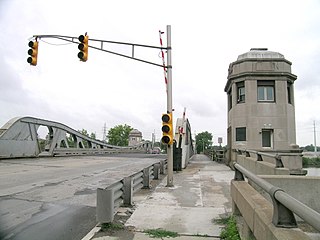
The Highway 2 Bridge is an automobile and pedestrian crossing of the Kansas River on the border of Johnson and Leavenworth Counties in De Soto. The current bridge was built in 1964.

U.S. Route 67 (US 67) is a component of the United States Numbered Highway System that connects Presidio, Texas, to Sabula, Iowa. In Illinois, it serves the western region of the state known as Forgottonia, named for the lack of regional transportation and infrastructure projects. The highway begins its path through the state by crossing the Clark Bridge over the Mississippi River from Missouri at Alton and heads northward through Jerseyville and Jacksonville before it crosses the Illinois River at Beardstown. The northern half of the route serves Macomb and Monmouth before it enters the Quad Cities. It leaves the state at Rock Island by crossing the Rock Island Centennial Bridge over the Mississippi River into Davenport, Iowa.

Haskell Limestone is a geological unit name originating in Kansas and used in adjoining states. The Pennsylvanian period unit was named by R.C. Moore for the Haskell Institute in the southeast of Lawrence, Kansas in 1931. The name has been applied to various beds within this range, and assigned as a member variously to the Lawrence Formation, Cass Formation, and Stranger Formation, and significant legacy literature exists for each classification. These three formations now comprise the Douglas Group.

The Bowersock Dam is a run-of-river dam on the Kansas River in Lawrence, Kansas. Constructed in 1874 to provide mechanical power, it now hosts the only hydroelectric plant in the state of Kansas. The dam, which is 655 feet long and approximately 17.08 feet tall, supplies water to two hydroelectric powerhouses, which have a combined installed capacity of seven megawatts. It impounds a 423-acre reservoir, which is used for recreation and as a water source for one of Lawrence's water treatment plants.
