Euharlee is a city in Bartow County, Georgia, United States. The population was 4,136 at the 2010 census, an increase of 29% over the 2000 count of 3,208.

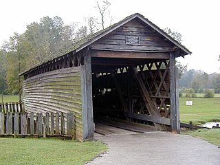
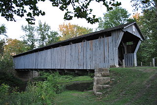
Watson Mill Bridge State Park is a 1,018-acre (4.12 km2) Georgia state park located near Comer and Carlton on the South Fork of the Broad River. The park is named for the Watson Mill Bridge the longest original-site covered bridge in Georgia, which spans 229 feet (70 m) across the South Fork of the Broad River. The site is listed on the National Register of Historic Places as the Watson Mill Covered Bridge and Mill Historic District. The bridge, built in 1885, is supported by a Town lattice truss system held together with wooden pegs also known as trunnels. Georgia once had over 200 covered bridges, but only 20 now remain. The park also offers a scenic nature trail and a new hiking/riding trail that winds through the thick forests and along the rivers edge.

A lattice truss bridge is a form of truss bridge that uses many small, closely spaced diagonal elements forming a lattice. The design was patented in 1820 by architect Ithiel Town.

The Cornish–Windsor Covered Bridge is a 158-year-old, two-span, timber Town lattice-truss, interstate, covered bridge that crosses the Connecticut River between Cornish, New Hampshire, and Windsor, Vermont. Until 2008, when the Smolen–Gulf Bridge opened in Ohio, it had been the longest covered bridge in the United States.

The P Street Bridge or Lauzun's Legion Bridge is a 336-foot (102 m) concrete arch bridge that conveys P Street across Rock Creek and Rock Creek Park between the Georgetown and Dupont Circle neighborhoods of Northwest Washington, D.C. Built in 1935, it replaced an older iron truss bridge.
The Coldwater Covered Bridge, also known as the Hughes Mill Covered Bridge, is a locally owned wooden covered bridge that spans the outflow from Oxford Lake in Calhoun County, Alabama, United States. It is located at Oxford Lake Park off State Route 21 in the city of Oxford, about 4 miles south of Anniston.

The Salem-Shotwell Covered Bridge, also known as the Pea Ridge Covered Bridge, is a locally owned wooden covered bridge that spans Rocky Brook in Lee County, Alabama, United States. It is located halfway down Park Road at Opelika Municipal Park, which is off North 5th Street in the city of Opelika. Coordinates are 32°39′33.46″N85°22′52.94″W.
Copeland Bridge, also known as Copeland Farm Bridge or Copeland Covered Bridge is a wooden covered bridge over Beecher Creek in the town of Edinburg in Saratoga County, New York. It was built in 1879, and is a small, timber framed, queenpost truss bridge with a gable roof. It has a 30-foot span carried on fieldstone abutments.

Poole's Mill Bridge is a historic wooden covered bridge crossing over Settendown Creek in Forsyth County, Georgia, United States, built in 1901. It is 96 feet long.
The Waterford Covered Bridge is a Town lattice truss covered bridge spanning LeBoeuf Creek in Waterford Township, Erie County in the U.S. state of Pennsylvania. The bridge was built in 1875, and is 85 feet 11 inches (26.2 m) in length. The Waterford Covered Bridge is one of two remaining covered bridges in Erie County, along with the Harrington Covered Bridge. The bridge is also the only Town lattice truss bridge in the county and one of only 19 in Pennsylvania. It was documented by the Historic American Buildings Survey in 1936 and was listed on the National Register of Historic Places in 1980. In 2011, the bridge was closed due to its deteriorating condition.
Bergstresser / Dietz Bridge, the last remaining covered bridge in Franklin County, Ohio, United States, is located within the village limits of Canal Winchester, Ohio in southeastern Franklin County. The wooden bridge crosses Little Walnut Creek, which is a tributary of the Scioto River. Although the bridge is in serviceable condition, it is only open to foot traffic.

The Contoocook Railroad Bridge is a covered bridge on the former Contoocook Valley Railroad line spanning the Contoocook River in the center of the village of Contoocook, New Hampshire, United States. It is referred to in the National Register of Historic Places as the Hopkinton Railroad Covered Bridge, for the town of Hopkinton, New Hampshire, in which the village of Contoocook is located.

Black Pioneers Cemetery in Euharlee, Georgia was in use from approximately 1830–1900, and had over 300 graves. It was largely forgotten until 2002 when Euharlee Historical Society saved the site from development.

The Sachs Covered Bridge, also known as Sauck's Covered Bridge and Waterworks Covered Bridge, is a 100-foot (30 m), Town truss covered bridge over Marsh Creek between Cumberland and Freedom Townships, Adams County in the U.S. state of Pennsylvania. The bridge was also known as the Sauches Covered Bridge at the time of the Battle of Gettysburg. It was listed on the National Register of Historic Places in 1980.

The Mull Covered Bridge is a historic wooden covered bridge in the northwestern portion of the U.S. state of Ohio. Built in the middle of the nineteenth century, it is located near Burgoon in Sandusky County. Although it is no longer used to facilitate transportation, the bridge has been preserved and is now a historic site.

The Covered Bridge in Cedarburg, Ozaukee County, Wisconsin, United States, is one of the last remaining covered bridges in that state, which once had about 40 covered bridges. Built in 1876 to cross Cedar Creek, the bridge is 120 feet (37 m) long and is made of pine with oak lattices. It was listed on the National Register of Historic Places in 1973 and is now used only for pedestrian traffic.

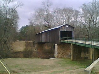
Howard's Covered Bridge is a historic covered bridge outside of Smithonia in Oglethorpe County, Georgia, United States. It was added to the National Register of Historic Places on July 1, 1975. The bridge is located 3 miles southeast of Smithonia on SR S2164. The bridge was built in 1905 in a Town lattice design and is 168 feet long. The span travels over Big Clouds Creek. The site is marked by a historical marker posted by the Georgia Historical Society. The bridge was named for the pioneer family that settled in the area in the late 1700s. It was built with convict labor and is fastened with wooden trunnels. The timber used was transported on the Smithonia and Dunlap Railroad, connecting James Monroe Smith's farm with the Georgia Railroad at Dunlap, Georgia.

The Red Oak Creek Covered Bridge carries Covered Bridge Road across Red Oak Creek north of Woodbury, Georgia. It was listed on the National Register of Historic Places in 1973.

The Cromer's Mill Covered Bridge, spanning Nails Creek near Carnesville, Georgia, was built in 1907. It was listed on the National Register of Historic Places in 1976.


