Eulma | |
|---|---|
 | |
 Eulma | |
| Coordinates: 36°44′20″N7°27′42″E / 36.73889°N 7.46167°E | |
| Country | Algeria |
| Province | Annaba |
| Population (2008) [1] | |
| • Total | 10,136 |
| Time zone | UTC+1 (West Africa Time) |
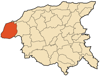
Eulma is a town in north-eastern Algeria.
Eulma | |
|---|---|
| | |
| Eulma | |
| Coordinates: 36°44′20″N7°27′42″E / 36.73889°N 7.46167°E | |
| Country | Algeria |
| Province | Annaba |
| Population (2008) [1] | |
| • Total | 10,136 |
| Time zone | UTC+1 (West Africa Time) |
Eulma is a town in north-eastern Algeria.

Algeria, officially the People's Democratic Republic of Algeria, is a country in North Africa. Algeria is bordered to the northeast by Tunisia; to the east by Libya; to the southeast by Niger; to the southwest by Mali, Mauritania, and Western Sahara; to the west by Morocco; and to the north by the Mediterranean Sea. It is considered part of the Maghreb region of North Africa. It has a semi-arid geography, with most of the population living in the fertile north and the Sahara dominating the geography of the south. Algeria covers an area of 2,381,741 square kilometres (919,595 sq mi), making it the world's tenth largest nation by area, and the largest nation in Africa, being more than 200 times as large as the smallest country in the continent, The Gambia. With a population of 44 million, Algeria is the ninth-most populous country in Africa, and the 32nd-most populous country in the world. The capital and largest city is Algiers, located in the far north on the Mediterranean coast.

This article is about the demographic features of the population of Algeria, including population density, ethnicity, education level, health of the populace, economic status, religious affiliations and other aspects of the population.
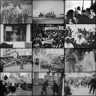
The Algerian War, also known as the Algerian Revolution or the Algerian War of Independence, and sometimes in Algeria as the War of 1 November, was fought between France and the Algerian National Liberation Front from 1954 to 1962, which led to Algeria winning its independence from France. An important decolonization war, it was a complex conflict characterized by guerrilla warfare and war crimes. The conflict also became a civil war between the different communities and within the communities. The war took place mainly on the territory of Algeria, with repercussions in metropolitan France.

French Algeria, also known as Colonial Algeria, was the period of French colonisation of Algeria. French rule in the region began in 1830 with the invasion of Algiers and lasted until the end of the Algerian War of Independence in 1962. While the administration of Algeria changed significantly over the 132 years of French rule, the Mediterranean coastal region of Algeria, housing the vast majority of its population, was an integral part of France from 1848 until its independence.

Adrar is a province (wilaya) in southwestern Algeria, named after its capital Adrar. It is the second-largest province, with an area of 424,948 km2, roughly the size of the US state of California. It had 402,197 inhabitants at the 2008 population census.
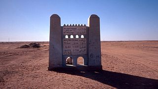
Reggane is a town and commune, and the capital of Reggane District, in Adrar Province, central Algeria. Reggane lies in the Sahara Desert near an oasis. According to the 2008 census it has a population of 20,402, up from 14,179 in 1998, with an annual growth rate of 3.8%. Berber tribes and people live in and around Reggane.

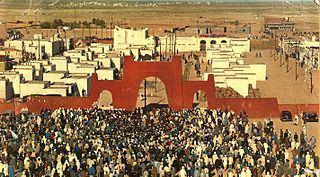
El Oued, Souf or Oued Souf is a city, and the capital of El Oued Province, in Algeria. The oasis town is watered by an underground river, hence its name is El Oued which enables date palm cultivation and the rare use of brick construction for housing. As most roofs are domed, it is known as the "City of a Thousand Domes".

The Sétif and Guelma massacre was a series of attacks by French colonial authorities and pied-noir settler militias on Algerian civilians in 1945 around the market town of Sétif, west of Constantine, in French Algeria. In response to French police firing on demonstrators at a protest on 8 May 1945, riots in the town were followed by attacks on French settlers (colons) in the surrounding countryside, resulting in 102 deaths. The French colonial authorities and European settlers retaliated by killing between 6,000 and 30,000 Muslims in the region. Both the outbreak and the indiscriminate nature of its retaliation marked a turning point in Franco-Algerian relations, leading to the Algerian War of 1954–1962.

Adrar is the administrative capital of Adrar Province, the second largest province in Algeria. The commune is sited around an oasis in the Touat region of the Sahara Desert. According to a 2008 census it has a population of 64,781, up from 43,903 in 1998, with an annual growth rate of 4.0%.

Bordj Badji Mokhtar is a town and commune in Bordj Badji Mokhtar District, Bordj Badji Mokhtar Province, in south-western Algeria. According to the 2008 census it has a population of 16,437, up from 9,323 in 1998, with an annual growth rate of 6.0%, the highest in the province. It was named after the Algerian independence activist Badji Mokhtar (1919–1954).

Tamanrasset, also known as Tamanghasset or Tamenghest, is an oasis city and capital of Tamanrasset Province in southern Algeria, in the Ahaggar Mountains. It is the chief city of the Algerian Tuareg. It is located an altitude of 1,320 metres (4,330 ft). As of the 2008 census, it has a population of 92,635, up from 72,741 in 1998, with an annual growth rate of 2.5%.

Aïn Defla is the capital city of Aïn Defla Province, Algeria. It is also a commune.
Tindouf is the main town, and a commune in Tindouf Province, Algeria, close to the Mauritanian, Western Saharan and Moroccan borders. The commune has population of around 160,000 but the census and population estimates do not count the Sahrawi refugees making the population as of the 2008 census 45,966, up from 25,266 in 1998, and an annual population growth rate of 6.3%.
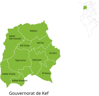
Kef Governorate is one of the twenty-four governorates of Tunisia. It comprises chiefly part of the dorsal Atlas Mountains and their foothills in north-western Tunisia, bordering Algeria. It covers an area of 4,965 km2 and has a population of 243,156. The capital is El Kef.

Illizi is a town and commune, coextensive with Illizi District, situated in the south-eastern part of Algeria, and capital of Illizi Province. According to the 2008 census it is the largest commune by population in the province, with a population of 17,252, up from 10,163 in 1998, and an annual population growth rate of 5.5%, the highest in the province. It is one of the gates to the Tassili N'Ajjer National Park with caves situated under the sands containing prehistoric drawings dating from 6000 years BC. There is a hotel and two camping sites, as well as many local tourist agencies.

Boukadir is a town and commune in Chlef Province, Algeria. According to the 1998 census it has a population of 41,655.
Dahra, Algeria is a town and commune in Chlef Province, Algeria. According to the 1998 census it has a population of 21,284.

Trifaoui is a town and commune in Hassi Khelifa District, El Oued Province, Algeria. According to the 2008 census it has a population of 8,257, up from 6,361 in 1998, and an annual growth rate of 2.7%.

Tadjenanet, formerly called Saint-Donat, is a town and commune in Mila Province, Algeria.

Ouled Sabor is a town and commune in Sétif Province in north-eastern Algeria.
| Annaba District |  | |
|---|---|---|
| Aïn El Berda District | ||
| El Hadjar District | ||
| Berrahal District | ||
| Chetaïbi District | ||
| El Bouni District | ||
| | This article about a location in Annaba Province is a stub. You can help Wikipedia by expanding it. |