
Harlan County is a county located in southeastern Kentucky. As of the 2020 census, the population was 26,831. Its county seat is Harlan. It is classified as a moist county—a county in which alcohol sales are prohibited, but containing a "wet" city, in this case Cumberland, where package alcohol sales are allowed. In the city of Harlan, restaurants seating 100+ may serve alcoholic beverages.

Daviess County ( "Davis"), is a county in Kentucky. As of the 2020 census, the population was 103,312. Its county seat is Owensboro. The county was formed from part of Ohio County on January 14, 1815.

Rathbun is a city in Appanoose County, Iowa, United States. The population was 43 at the time of the 2020 census.

Marysville is a city in Marion County, Iowa, United States. The population was 44 at the time of the 2020 census.

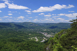
Pineville is a home rule-class city in Bell County, Kentucky, United States. It is the seat of its county. The population was 1,732 as of the 2010 census. It is located on a small strip of land between the Cumberland River and Pine Mountain.

Wayland is a home rule-class city in Floyd County, Kentucky, United States. The population was 426 at the 2010 census, up from 298 at the 2000 census.

Wheelwright is a home rule-class city in Floyd County, Kentucky, United States. The population was 780 at the 2010 census, down from 1,042 in 2000.

Jenkins is a home rule-class city in Letcher County, Kentucky, United States. The population was 2,203 as of the 2010 census.

Lima Township is a civil township of Washtenaw County in the U.S. state of Michigan. The population was 3,307 at the 2010 census.

Rivesville is a town and former coal town in Marion County, West Virginia, United States. The population was 830 at the 2020 census.
The Middlesboro crater is a meteorite crater in Kentucky, United States. It is named after the city of Middlesborough, which today occupies much of the crater.

The Big South Fork of the Cumberland River is a 76-mile-long (122 km) river in the U.S. states of Tennessee and Kentucky. It is a major drainage feature of the Cumberland Plateau, a major tributary of the Cumberland River system, and the major feature of the Big South Fork National River and Recreation Area.
Fountain Green is an unincorporated community located about eleven miles northeast of Carthage, Illinois, United States in Fountain Green Township, Hancock County, Illinois.
Cornettsville is an unincorporated community in Perry County, Kentucky, United States, within the state's eastern mountain region known for coal mining. The population is 792 as of the 2000 United States Census. The town was named for one of the early pioneers to the area, William Jesse Cornett, whose log cabin and burial site can still be seen today.
Van Lear is an unincorporated community and coal town in Johnson County, Kentucky, United States.
The Red Bird River is one of two tributaries at the head of the South Fork of the Kentucky River, the other being the Goose Creek. It is located in the Daniel Boone National Forest in extreme southeastern portion of the U.S. state of Kentucky. It is 34.3 miles (55.2 km) long and drains an area of 195.7 square miles (507 km2).
Stone is an unincorporated community and coal town in Pike County, Kentucky, United States. It was established in 1912. Stone was a mining community named for Galen Stone, head of the Pond Creek Coal Company which was based in Stone. In 1922 the Pond Creek Coal Company was sold to Fordson Coal Company, which was a subsidiary of Ford Motor Company. In 1936 Fordson sold the mine at Stone to Eastern Coal Company.
Drift, Kentucky is an unincorporated community and coal town in Floyd County, Kentucky, United States. As of the census of 2000, there were 569 people living in the ZIP Code Tabulation Area (ZCTA) for Drift's ZIP code (41619).
Ridgeway is an unincorporated community in Harlan County, in the U.S. state of Kentucky.

Tercio is a ghost town and former coal mine in Las Animas County, in the U.S. state of Colorado. The GNIS classifies it as a populated place. A post office called Tercio was established in 1902, and remained in operation until 1949. The community was the third coal mining community established by the Colorado Fuel and Iron company, hence the name.
