
Cartography is the study and practice of making and using maps. Combining science, aesthetics and technique, cartography builds on the premise that reality can be modeled in ways that communicate spatial information effectively.

A mappa mundi is any medieval European map of the world. Such maps range in size and complexity from simple schematic maps 25 millimetres or less across to elaborate wall maps, the largest of which to survive to modern times, the Ebstorf map, was around 3.5 m in diameter. The term derives from the Medieval Latin words mappa and mundus (world).

A world map is a map of most or all of the surface of Earth. World maps, because of their scale, must deal with the problem of projection. Maps rendered in two dimensions by necessity distort the display of the three-dimensional surface of the earth. While this is true of any map, these distortions reach extremes in a world map. Many techniques have been developed to present world maps that address diverse technical and aesthetic goals.

The De Virga world map was made by Albertinus de Virga between 1411 and 1415. The map contains a mention in small letters:
The earliest known world maps date to classical antiquity, the oldest examples of the 6th to 5th centuries BCE still based on the flat Earth paradigm. World maps assuming a spherical Earth first appear in the Hellenistic period. The developments of Greek geography during this time, notably by Eratosthenes and Posidonius culminated in the Roman era, with Ptolemy's world map, which would remain authoritative throughout the Middle Ages. Since Ptolemy, knowledge of the approximate size of the Earth allowed cartographers to estimate the extent of their geographical knowledge, and to indicate parts of the planet known to exist but not yet explored as terra incognita.

The Geography, also known by its Latin names as the Geographia and the Cosmographia, is a gazetteer, an atlas, and a treatise on cartography, compiling the geographical knowledge of the 2nd-century Roman Empire. Originally written by Claudius Ptolemy in Greek at Alexandria around AD 150, the work was a revision of a now-lost atlas by Marinus of Tyre using additional Roman and Persian gazetteers and new principles. Its translation into Arabic in the 9th century was highly influential on the geographical knowledge and cartographic traditions of the Islamic world. Alongside the works of Islamic scholars - and the commentary containing revised and more accurate data by Alfraganus - Ptolemy's work was subsequently highly influential on Medieval and Renaissance Europe.

Francesco Rosselli was an Italian miniature painter, and engraver of maps and old master prints. He was described as a cartographer, although his contribution did not include any primary research and was probably limited to engraving, decorating and selling manuscript maps created by others. He created many maps, including one of the first printed maps of the world to depict the Americas after Christopher Columbus' voyages. The attribution of prints to him is the subject of debate, as different engraving styles are used. This may be the result of different artists in his workshop, or of his and his shop's ability to use different styles.
Medieval Islamic geography and cartography refer to the study of geography and cartography in the Muslim world during the Islamic Golden Age. Muslim scholars made advances to the map-making traditions of earlier cultures, particularly the Hellenistic geographers Ptolemy and Marinus of Tyre, combined with what explorers and merchants learned in their travels across the Old World (Afro-Eurasia). Islamic geography had three major fields: exploration and navigation, physical geography, and cartography and mathematical geography. Islamic geography reached its apex with Muhammad al-Idrisi in the 12th century.
The cartography of India begins with early charts for navigation and constructional plans for buildings. Indian traditions influenced Tibetan and Islamic traditions, and in turn, were influenced by the British cartographers who solidified modern concepts into India's map making.
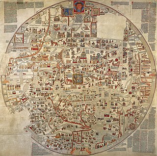
The Ebstorf Map was an example of a mappa mundi. It was made by Gervase of Ebstorf, who was possibly the same man as Gervase of Tilbury, some time between 1234 and 1240.
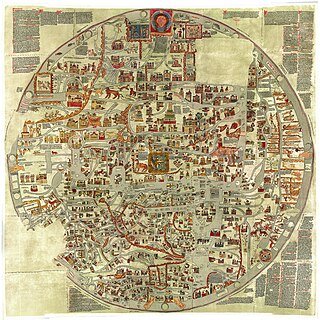
Gervase of Ebstorf is best known as the author of the Ebstorf Map, a medieval mappa mundi created between 1234 and 1240.

Elisabeth (Elly) Dekker is a Dutch astronomer and science historian, specialising in the history of astronomy. She studied theoretical physics and astronomy at Utrecht University. In 1975 she obtained a PhD in astronomy at Leiden University with the thesis Spiral structure and the dynamics of flat stellar systems supervised by Hendrik C. van de Hulst. From 1978-1988 she was a curator of Museum Boerhaave in Leiden and afterwards an independent scholar. From 1993-1995 she was a Sackler fellow of the Royal Museums Greenwich. In 1998 she was awarded the Caird Medal for her work on the globe collection of the National Maritime Museum in Greenwich.

Giovanni da Carignano, or Johannes de Mauro de Carignano, was a priest and a pioneering cartographer from Genoa.
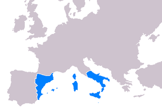
Cartography throughout the 14th-16th centuries played a significant role in the expansion of the kingdoms of the Iberian Peninsula for a multitude of reasons. Primarily, the maps developed during this period served as navigational tools for maritime folk such as explorers, sailors and navigators. Mostly the expansion of the Crown of Aragon (which included the Kingdom of Aragon, Kingdom of Valencia and Kingdom of Majorca, together with the Principality of Catalonia, all its territories with seashore on the Mediterranean Sea. The Crown of Aragon controlled the routes across the Mediterranean Sea from the Kingdom of Jerusalem to Europe, as part of the commercial-trade route known as the Silk Road.

Mainly a decoration piece, the Borgia map is a world map made sometime in the early 15th century, and engraved on a metal plate. Its "workmanship and written explanations make it one of the most precious pieces of the history of cartography".

Candyn was a supposed remote east-Asian island around the turn of the 15th century.
Giovanni Leardo was a 15th-century Venetian geographer and cosmographer. Leardo made at least four mappae mundi, of which three survive today.

The cartography of Jerusalem is the creation, editing, processing and printing of maps of Jerusalem from ancient times until the rise of modern surveying techniques. Almost all extant maps known to scholars from the pre-modern era were prepared by Christian mapmakers for a Christian European audience.
Emilie Savage-Smith is an American-British historian of science known for her work on science in the medieval Islamic world and medicine in the medieval Islamic world.
Natalia Lozovsky is a medievalist and translator, whose research focuses on science and geography in the medieval period. She has also demonstrated how ninth and tenth century works on geography, often draw on other literary traditions, such as exegesis. She also writes on how classical knowledge of geography was received by medieval Christian scholarship. She has worked on the lives and writings of Isidore of Seville, Dicuil, Ravenna Cosmographer and Orosius, amongst others.