Langlade County is a county located in the U.S. state of Wisconsin. As of the 2020 census, the population was 19,491. Its county seat is Antigo.
Kewaunee County is a county located in the U.S. state of Wisconsin. As of the 2020 census, the population was 20,563. Its county seat is Kewaunee. The county was created in 1852 and organized in 1859. Its Menominee name is Kewāneh, an archaic name for a species of duck. Kewaunee County is part of the Green Bay, WI Metropolitan Statistical Area as well as the Green Bay-Shawano, WI Combined Statistical Area.

Evergreen is a town in Langlade County, Wisconsin, United States. The population was 495 as of the 2010 census. The unincorporated communities of Elton and Four Corners are located in the town.

Wolf River is a town in Langlade County, Wisconsin, United States. The population was 731 at the 2010 census, down from 856 at the 2000 census. The unincorporated communities of Hollister, Langlade, and Markton and the ghost town of Van Ostrand are in the town. The village of White Lake, a separate municipality, is surrounded by the town.

Lake Delton is a man-made freshwater lake in Sauk County in central Wisconsin. For much of 2008, it was a mostly empty lake basin after a portion of a county highway that forms part of the dike wall eroded on June 9, 2008, under the pressure of floods in the area. The resulting washout caused the lake to empty into the Wisconsin River, leaving behind only rainwater pools and the flow from Dell Creek. By March 2009, major repairs to correct the problem were completed, and the lake was allowed to refill. Minor repairs were expected to continue after that time, but the lake is now completely refilled and has been usable since Memorial Day weekend of 2009.

The Wolf River is a 225 mi (362 km) long tributary of the Fox River in northeastern Wisconsin in the Great Lakes region of the United States. The river is one of the two National Scenic Rivers in Wisconsin, along with the St. Croix River. The scenic portion is 24 miles (39 km) long. The river and its parent the Fox River and associated lakes are known for their sturgeon which spawn every spring upstream on the lower river until blocked by the Shawano Dam. The river flows through mostly undeveloped forestland southerly from central Forest County in the north to Lake Poygan in the south. The lake is part of the Winnebago Pool of lakes fed by both the Fox and Wolf Rivers. The Fox-Wolf basin is usually considered to be a single unified basin and the rivers themselves may be referred to as the Fox-Wolf River system.
Wisconsin's 7th congressional district is a congressional district of the United States House of Representatives in northwestern and central Wisconsin; it is the largest congressional district in the state geographically, covering 20 counties, for a total of 18,787 sq mi. The district contains the following counties: Ashland, Barron, Bayfield, Burnett, St. Croix, Chippewa (partial), Clark, Douglas, Florence, Forest, Iron, Jackson (partial), Juneau (partial), Langlade, Lincoln, Marathon, Monroe (partial), Oneida, Polk, Price, Rusk, Sawyer, Taylor, Vilas, Washburn, and Wood (partial).
Green Lake — also known as Big Green Lake — is a lake in Green Lake County, Wisconsin, United States. Green Lake has a maximum depth of 237 ft (72 m), making it the deepest natural inland lake in Wisconsin and the second largest by volume. The lake covers 29.72 km2 and has an average depth of 30.48 m (100.0 ft). Green Lake has 43.94 km (27.30 mi) of diverse shoreline, ranging from sandstone bluffs to marshes.

Wisconsin, a state in the Midwestern United States, has a vast and diverse geography famous for its landforms created by glaciers during the Wisconsin glaciation 17,000 years ago. The state can be generally divided into five geographic regions—Lake Superior Lowland, Northern Highland, Central Plain, Eastern Ridges & Lowlands, and Western Upland. The southwestern part of the state, which was not covered by glaciers during the most recent ice age, is known as the Driftless Area. The Wisconsin glaciation formed the Wisconsin Dells, Devil's Lake, and the Baraboo Range. A number of areas are protected in the state, including Devil's Lake State Park, the Apostle Islands National Lakeshore, and the Chequamegon–Nicolet National Forest.

Kohler-Andrae State Park comprises two adjacent Wisconsin state parks located in the Town of Wilson, a few miles south of the city of Sheboygan. They are managed as one unit. Terry Andrae State Park, established in 1927, and John Michael Kohler State Park, established in 1966, total 988 acres (4.00 km2). The parks contain over two miles (3 km) of beaches and sand dunes along the shore of Lake Michigan, with woods and wetlands away from the water. The Black River flows through the parks.

Castle Rock Lake is an artificial lake on the Wisconsin River. It is located in central Wisconsin in Adams County and Juneau County. The lake has an inflow from Petenwell Lake, Yellow River, Big Roche a Cri., and Klien Creek. It has a surface area of 16,640 acres (67.3 km2) and its depth varies from 8–20 ft (2.4–6.1 m) in most places, with area in the old river beds reaching as deep as 35 ft (11 m).
Menominee River State Recreation Area is a state-managed protected area located in Breitung and Norway townships in Dickinson County and Faithorn Township in Menominee County, Michigan, southeast of Iron Mountain. It is 2,354 acres (953 ha) in area and is currently undeveloped. The park comprises a 145.35-acre (58.82 ha) tract along 1.5 miles (2.4 km) of the Menominee River south of the City of Norway and the 2,208.83-acre (893.88 ha) Quiver Falls Tract along eight miles (13 km) of the river farther downstream. In 2016, an additional 525-acre (212 ha) of Escanaba State Forest land was transferred from the Forestry Division to the DNR's Parks and Recreation Division and became the Pemene Falls Unit of the park, matching a similarly-named unit on the Wisconsin side of the river.

The Turtle-Flambeau Flowage is a 12,942 acres (52.37 km2) lake in Iron County, Wisconsin. It has a maximum depth of 15 meters and is the seventh largest lake in the state of Wisconsin by surface area. The flowage is home to unique wetland patterns and plant species as well as several species of sport and game fish, including Musky, Panfish, Largemouth Bass, Smallmouth Bass, Northern Pike, Walleye and Sturgeon. The lake's water clarity is low, but can vary in different locations in the lake. Fishing, camping, boating, and hunting are popular activities on the flowage, and Ojibwe people traditionally harvest fish and game on the lake. Environmental concerns on the flowage include mercury contamination, algal blooms, and several types of invasive species.

There are a variety of schema for dividing Wisconsin into regions.

Parfrey's Glen, located within Devil's Lake State Park, is a Wisconsin Department of Natural Resources-designated State Natural Area. The glen is a deep gorge cut through the sandstone of the south flank of the Baraboo Hills. It was the first State Natural Area to be designated in Wisconsin. The valley was named for Robert Parfrey.
The flora of Door County, Wisconsin comprise a variety of plant species. Geobotanically, Door County belongs to the North American Atlantic Region.
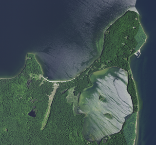
Mackaysee Lake is a lake located in Door County, Wisconsin. The lake is found on Chambers Island in Green Bay of Lake Michigan. Mackaysee Lake has a surface area of 347 acres (1.40 km2) and a max depth of 27 ft (8.2 m). Most of the lake has a sand bottom and is shallow with an average depth of 6 ft (1.8 m). There are two islands in Mackaysee Lake. Both are owned by the Door County Land Trust and are protected in the Chambers Island Nature Preserve. The islands are classified as third order recursive islands due to being in a lake on an island in a lake.

Little Lake is a lake located in Door County, Wisconsin. The lake is found on Washington Island in Green Bay of Lake Michigan. Little Lake has a surface area of 41 acres (0.17 km2) and a max depth of 6 ft (1.8 m). Most of the lake is shallow and has a bottom that is muck. Although the northwest corner of the lake is only 250 ft (76 m) from Lake Michigan, the lake is spring fed. It is a recursive lake, due to it being a lake on an island. The shore around the lake is partially owned by the Door County Land Trust. This area is designated as a Wisconsin State Natural Area by the Wisconsin Department of Natural Resources.
The Swan Lake Wildlife Area is a 2,466 acres (998 ha) tract of protected land located in Columbia County, Wisconsin, managed by the Wisconsin Department of Natural Resources (WDNR). Land to be used for the Wildlife Area was first acquired in 1963 to provide for hunting and other outdoor recreational activities in the county. In addition to outdoor recreation activities, the Wildlife Area was established to protect the Fox River watershed.