F. Llamas Street

Last updated

F. Llamas Street
F. Llamas Street sign v2.png
Calle de Fernando Llamas (Spanish)
F. Llamas Street 2.jpg
End point of F. Llamas Street, Cebu City heading towards N. Bacalso Avenue
Native nameDalan F. Llamas (Cebuano)
NamesakeFrancisco Llamas Fernández
Length1.38 km (0.86 mi)
Based on DPWH Atlas 2019 [1]
Location Cebu City, Cebu, Philippines
FromN. Bacalso Avenue in Barangay Basak San Nicolas
Major
junctions
Tres de Abril Street/E. Sabellano Street
To Katipunan Street in Barangay Tisa

F. Llamas Street (Cebuano : Dalan F. Llamas) is a national tertiary road [1] in Cebu City, Cebu, Philippines. It commences at N. Bacalso Avenue in Barangay Basak San Nicolas, passes through the junction of Tres de Abril and E. Sabellano streets and ends at the junction of Katipunan Street in Barangay Tisa. It was formerly considered as a "national aid" city road under Executive Order No. 113 issued by President Ramon Magsaysay on May 2, 1955. [2]

Contents

The street is named after Francisco Llamas, a Cebuano revolutionary who was a member of Cebu's Katipunan led by Leon Kilat and whose house was sometimes used as the group's meeting place. [3]

Route description

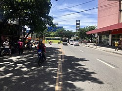
The street begins at N. Bacalso Avenue in Barangay Basak San Nicolas beside Super Metro Basak, passes along the junction of G. Elorde Street (formerly known as Ganciang Street) which divides the said barangay with Barangay Punta Princesa and proceeds towards the Archdiocesan Shrine of Our Lady of Lourdes. Upon reaching the junction of E. Sabellano Street, which is an alternative road for passengers going to south district barangays, and Tres de Abril Street, it goes on passing through several commercial and residential establishments before it reaches Barangay Tisa by passing through a small bridge which spans the Kinalumsan River. It then crosses the junction of Cabarrubias and F. Caburnay streets, curves northwest along Gaisano Capital Tisa and curves northeast as it reaches the Tisa Barangay hall. The street ends at the junction of Katipunan Street near where most of the barangay's well-known siomai and other food stores are located.

Landmarks

Connecting streets

See also

Related Research Articles

<span class="mw-page-title-main">Cebu City</span> Capital of Cebu, Philippines and Central Visayas, Philippines

Cebu City, officially the City of Cebu, is a 1st class highly urbanized city in the Central Visayas region of the Philippines. It is the capital of the Cebu Province, where it is geographically located but is one of three cities that are administratively independent of the provincial government. According to the 2020 census, it has a population of 964,169 people,  making it the sixth-most populated city in the nation and the most populous in the Visayas.

<span class="mw-page-title-main">Toledo, Cebu</span> City in Cebu province, Philippines

Toledo, officially the City of Toledo, is a 3rd class component city in the province of Cebu, Philippines. According to the 2020 census, it has a population of 207,314 people. 

<span class="mw-page-title-main">EDSA</span> Limited-access circumferential highway around Metro Manila

Epifanio de los Santos Avenue, commonly referred to by its acronym EDSA, is a limited-access circumferential highway around Manila, the capital city of the Philippines. It passes through 6 of Metro Manila's 17 local government units or cities, namely, from north to south, Caloocan, Quezon City, San Juan, Mandaluyong, Makati, and Pasay.

<span class="mw-page-title-main">Minglanilla</span> Municipality of the Philippines in the province of Cebu

Minglanilla, officially the Municipality of Minglanilla, is a 1st class municipality in the province of Cebu, Philippines. According to the 2020 census, it has a population of 151,002 people. 

<span class="mw-page-title-main">Don Vicente Rama Memorial National High School</span> Public high school, coeducational school in Macopa Street, Basak Pardo, Cebu City, Cebu, Philippines

Don Vicente Rama Memorial National High School is a public secondary school in Cebu City in the Philippines.

<span class="mw-page-title-main">Marikina–Infanta Highway</span> Scenic road in the Philippines

The Marikina–Infanta Highway, also known as Marilaque Highway, as well as its former name Marcos Highway, Marilaque Road or Marikina-Infanta Road, is a scenic mountain 117.5-kilometer (73.0 mi) highway that connects Metro Manila with Infanta, Quezon in the Philippines. Motorists colloquially refer to the road as Marilaque Highway.

<span class="mw-page-title-main">University of Cebu</span> Private university in Cebu City, Philippines

The University of Cebu (UC) is a private, non-sectarian, coeducational basic and higher education institution in Cebu City, Philippines. It was founded in 1964 offering preschool, grade school, junior & senior high school, undergraduate degrees, and post-graduate degrees. It currently has five campuses.

<span class="mw-page-title-main">Circumferential Road 5</span> Road in the Philippines

Circumferential Road 5 (C-5), informally known as the C-5 Road, is a network of roads and bridges that all together form the fifth beltway of Metro Manila in the Philippines. Spanning some 32.5 kilometers (20.2 mi), it connects the cities of Las Piñas, Makati, Parañaque, Pasay, Pasig, Quezon City, Taguig, and Valenzuela.

<span class="mw-page-title-main">DYHP</span> Radio station in Cebu City, Philippines

DYHPRMN Cebu is a radio station owned and operated by the Radio Mindanao Network. Its studios and offices are located at the RMN Broadcast Center, G/F Capitol Central Hotel and Suites, N. Escario St., cor. F. Ramos Ext., Capitol Site, Cebu City and at RMN Drama Production Center, Room 302, 3/F Jose R. Martinez Bldg., Osmeña Blvd., Cebu City; while its transmitter facilities are located along DYHP-IFM Transmitter Site, Sitio Seaside Asinan, Brgy. Basak San Nicolas, Cebu City. DYHP is the pioneer AM radio station in Cebu.

<span class="mw-page-title-main">Aurora Boulevard</span> Road in the Philippines

Aurora Boulevard is a four-to-ten lane major thoroughfare in Quezon City and San Juan in Metro Manila, Philippines. It was named after Doña Aurora Quezon, the consort of Commonwealth President Manuel Luis Quezon. It is one of the major roads in the commercial district of Araneta City in Cubao. Line 2 follows the alignment of the boulevard.

<span class="mw-page-title-main">Boni Avenue</span>

Boni Avenue is a major east–west thoroughfare in Mandaluyong, eastern Metro Manila, Philippines. It is a six-lane divided avenue that runs from Aglipay Street to Epifanio de los Santos Avenue (EDSA). After crossing EDSA via the EDSA-Boni tunnel, the road continues as Pioneer Street towards Pasig. The avenue is named after the nickname of Bonifacio Javier, a decorated guerrilla leader during World War II and former mayor of Mandaluyong.

<span class="mw-page-title-main">Osmeña Boulevard</span>

Osmeña Boulevard is a major arterial thoroughfare in Cebu City, Philippines. It is the city's "main street" which travels in a generally northwest–southeast orientation linking the old downtown district of San Roque near the harbor with the modern uptown Capitol Site district. Beginning at M.J. Cuenco Avenue in the east, the boulevard heads northwest towards Fuente Osmeña circle and ends at Escario Street. At its north end, the Cebu Provincial Capitol serves as a prominent terminating vista. It is the location of many of Cebu's notable institutions such as the Cebu Normal University, Abellana National School and Cebu Doctors' University Hospital; the Basilica of Santo Niño; one of the city's tallest buildings, Crown Regency Hotel; and shopping centers Robinsons Place Cebu and Gaisano Colon.

<span class="mw-page-title-main">Maysilo Circle</span> Roundabout in Mandaluyong, Philippines

The Maysilo Circle, is a roundabout in Mandaluyong, Metro Manila, the Philippines. It is located a few kilometers from Mandaluyong's border with Makati, just across the Pasig River through San Francisco Street. The roundabout serves as a junction point between the northern and southern sections of Boni Avenue, F. Martinez Avenue, San Francisco Street, and Sgt. Bumatay Street in the southern part of the city.

National Route 62 (N62) forms part of the Philippine highway network. It runs south from Metro Manila to northeastern Cavite.

<span class="mw-page-title-main">Plainview, Mandaluyong</span> Barangay in Metro Manila, the Philippines

Plainview is an administrative division in eastern Metro Manila, the Philippines. It is an urban barangay in Mandaluyong and is home to the city's seat of government and government center. It is the fourth largest barangay in the city.

Tres de Abril Street is a national tertiary road in Cebu City, Cebu, Philippines. It commences at Spolarium Street in Barangay Pasil which connects Barangay Ermita through the Forbes Bridge, passes through the junctions of C. Padilla Street and N. Bacalso Avenue, and ends at the junction of F. Llamas Street in Barangay Punta Princesa. It was formerly considered as a national secondary road under Executive Order No. 113 issued by President Ramon Magsaysay on May 2, 1955.

Katipunan Street is a national tertiary road in Cebu City, Cebu, Philippines. It commences at the corner of N. Bacalso Avenue and V. Rama Avenue in Barangay Calamba, passes through the junctions of A. Lopez and Salvador streets and ends at the junction of F. Llamas Street in Barangay Tisa.

C. Padilla Street is a national tertiary road in Cebu City, Cebu, Philippines. It commences at Colon Street in Barangay Pahina Central, passes through several junctions in Barangays San Niolas Proper, Pahina San Nicolas, Sawang Calero and Duljo-Fatima and ends at the junction of F. Vestil Street and L. Gabuya Street in Barangay Mambaling.

<span class="mw-page-title-main">N8 highway</span>

National Route 8 (N8) is a 174-kilometer (108 mi), two-six lane north-south major primary national route that forms part of the Philippine Highway Network in the province of Cebu. There are two highways that make up the road: the Cebu North Road and Natalio Bacalso Avenue. It runs from Danao to Santander. The highway also forms part of the Philippine Nautical Highway System, particularly the Central Nautical Highway from Danao to Cebu City and Western Nautical Highway from Cebu City to Santander.

National Route 81 (N81) is a 34.6-kilometer (21.5 mi), east-west primary route which forms part of the Philippine Highway network in Cebu connecting the cities and municipalities of Naga Toledo, Pinamungahan, Aloguinsan and Barili. Two roads form the route, namely: Naga−Uling Road and Cebu−Toledo Wharf Road.

References

  1. 1 2 "DPWH Atlas 2019 - Cebu City". dpwh.gov.ph. Department of Public Works and Highways . Retrieved September 26, 2020.
  2. "Executive Order No. 113, s. 1955". officialgazette.gov.ph. Official Gazette. May 2, 1955. Retrieved September 23, 2020.
  3. Oaminal, Clarence Paul (June 27, 2017). "The Revolutionaries of Cebu (Ang Mangugubot Sa Sugbo)". The Freeman . Retrieved September 23, 2020.
  4. Fernandez, Rona Joyce (March 13, 2018). "Church detour seen to ease south traffic". Sun.Star Cebu . Retrieved September 23, 2020.
  5. Timtim, Alven Marie (October 26, 2019). "Tisa fire razes 3 homes". CDN Digital. Retrieved September 23, 2020.