Related Research Articles
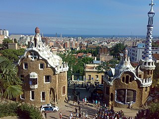
Parc Güell is a public park system composed of gardens and architectural elements located on Carmel Hill, in Barcelona, Catalonia, Spain. Carmel Hill belongs to the mountain range of Collserola – the Parc del Carmel is located on the northern face. Park Güell is located in La Salut, a neighborhood in the Gràcia district of Barcelona. With urbanization in mind, Eusebi Güell assigned the design of the park to Antoni Gaudí, a renowned architect and the face of Catalan modernism.
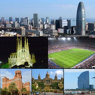
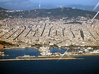
Barcelona is a city on the coast of northeastern Spain. It is the capital and largest city of the autonomous community of Catalonia, as well as the second most populous municipality of Spain. With a population of 1.6 million within city limits, its urban area extends to numerous neighbouring municipalities within the Province of Barcelona and is home to around 4.8 million people, making it the fifth most populous urban area in the European Union after Paris, the Ruhr area, Madrid, and Milan. It is one of the largest metropolises on the Mediterranean Sea, located on the coast between the mouths of the rivers Llobregat and Besòs, and bounded to the west by the Serra de Collserola mountain range, the tallest peak of which is 512 metres high.

The Besòs is a river flowing through Catalonia, Spain, formed by the confluence of the Mogent and Congost rivers. It ends in the Mediterranean. Its full watershed includes the following cities: Aiguafreda, La Garriga, Sant Fost de Campsantelles, Canovelles, Granollers, Montmeló, Mollet del Vallès, Montcada i Reixac, Santa Coloma de Gramenet, Barcelona and Sant Adrià de Besòs. Due to its Mediterranean climate, the river can have extreme discrepancies in flow depending on the weather.
The Serra de Collserola, or simply Collserola, is a mountain range between the rivers Besòs and Llobregat. It is part of the Catalan Coastal Range.

Barberà del Vallès is a municipality in the comarca of the Vallès Occidental, in the province of Barcelona, Spain. It is situated in the valley of the Ripoll river to the south of Sabadell, about 17 kilometers from Barcelona. It's integrated in the Metropolitan Area of Barcelona.

The Barcelona–Vallès Line is an unconnected standard gauge railway line linking Barcelona with Sabadell and Terrassa via the Collserola mountain range, in Catalonia, Spain. Its name refers to the Catalan historical region of Vallès, whereby most part of the line runs. Plaça de Catalunya station serves as the Barcelona terminus of the line, where almost all its trains either start or terminate. The line then continues northwards and branches off twice before leaving the city limits. Its main route splits in two in Sant Cugat del Vallès, forming two major branches to Sabadell and Terrassa. It has 40 passenger stations in operation and a total line length of 48.1 kilometres (29.9 mi).
Ifrane National Park is a national park located in the Middle Atlas mountain range, in Morocco. Its territory extends over the Western part of the Middle Atlas mountains and areas within the provinces of Ifrane and Boulmane. It was established in 2004,and covers an area of 125.000 ha. Much of the park is forested with Atlas cedar. Ifrane National Park is one of the few remaining habitats for the Barbary macaque, Macaca sylvanus; this primate prehistorically had a much broader range in North Africa, but currently survives as an endangered species in narrowly restricted and fragmented habitats.
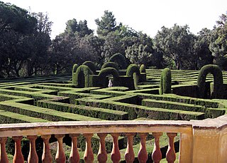
The Parc del Laberint d'Horta is a historical garden in the Horta-Guinardó district in Barcelona and the oldest of its kind in the city. Located on the former estate of the Desvalls family, next to the Collserola ridge, the park comprises an 18th-century neoclassical garden and a 19th-century romantic garden. On the lower terrace is the hedge maze that gives the park its name.

The Barcelona urban area is an urban area in Catalonia (Spain) centered on the city of Barcelona and located less than 100 km south of the border with France. With a population of over 5 million, it is the most populous urban area on the Mediterranean coast, and one of the largest in Europe.
Peri Urban Regions Platform Europe (PURPLE) is a network of European regions. It addresses the virtues and needs of the zone around the core cities of metropolitan areas. This peri-urban area is home to a large proportion of Europe's population and the location of companies from both the services and manufacturing sector, and of agriculture. PURPLE members feel that this zone is not addressed satisfactorily in European as well as national and regional plans and strategies.

The Àrea Metropolitana de Barcelona is a public body operating on the principle of metropolitan authority. It is composed of representatives of Barcelona and 36 adjacent municipalities accounting for a population of 3,239,337 within an area of 636 km2. Its jurisdiction constitutes the main core of the unofficial Barcelona metropolitan area, with a population over 5 million.
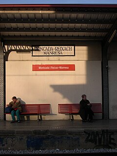
Public transport in Montcada i Reixac is a part of the transportation network in the Metropolitan Area of Barcelona. The town is located in a geographically strategic position, immediately to the north of Barcelona's Nou Barris district and surrounded by the hills of Collserola and the adjacent towns of Vallès, and contains a few train stations which articulate the rail transport in the urban region.
The Green Belt of Vitoria-Gasteiz is a set of urban parks with high ecological value, strategically linked by eco-recreational corridors. It is the result of an ambitious plan of restoration and reclamation on the outskirts of the city that seeks to recover the ecological and social value of this space through the creation of a nature tour around the city articulated by various enclaves of high ecological value and landscape. It is the result of a project which began in the early 1990s and was selected by the UN among the 100 best global performances of the III International Competition "Best Practices for improving the living conditions of the cities", held in Dubai in the year 2000. Currently, it has five established parks: Armentia, Olarizu, Salburua, Zabalgana and Zadorra.
The Cabrera Archipelago Maritime-Terrestrial National Park is a national park that includes the whole of the Cabrera Archipelago in the Balearic Islands, an autonomous community that is part of Spain. The park is the largest in Spain, covering 908 square kilometres (351 sq mi) including 895 square kilometres (346 sq mi) of sea area. The park attracts relatively few visitors due to its remoteness. There is no permanent population, but there might be at any given time just under 100 National Park staff members and other personnel on the islands.
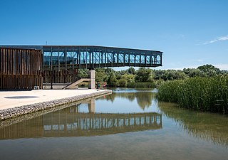
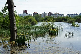
Ataria Interpretation Centre is a wetlands interpretation centre and natural history museum for the Salburua wetlands, a Ramsar site and a significant wetlands habitat in the Basque Autonomous Community. The wetlands region is an important green belt on the eastern outskirts of the city of Vitoria - Gasteiz in Álava-Araba province. Ataria showcases the value of the wetlands, which are classified as a class 1 Habitat of European Community Interest, and the importance of biodiversity to Vitoria-Gasteiz's natural heritage. The Salburua marshes are considered to be "the Basque country's most valuable area of wetland", according to a Fedenatur report for the European Commission in 2004.

Euralille is an urban quarter in the centre of Lille, France. Conceived as a major European business district in the 1980s, it is strategically located at the intersection of the high-speed railway lines linking Paris, Brussels, and London, and incorporates the Gare de Lille Europe and Gare de Lille Flandres railway stations. The master plan was commissioned in 1988 to the Office of Metropolitan Architecture (OMA) led by Rem Koolhaas.

The Beigua Natural Regional Park is a natural park located in province of Savona and the Metropolitan City of Genoa, both in Liguria (Italy). It's the largest protected area of the region. It gets the name from the highest mountain of the area, Monte Beigua.

Forêts National Park is a French national park located in the northeastern part of metropolitan France, not far from Dijon to the north. It protects the broad-leaved trees typical of the southeastern Paris Basin plateau.
Grand Parc de L'Ouest is a planned park along the north shore of the western part of Montreal, Quebec, Canada.
References
- ↑ "Biodiversity and Natura 2000 in urban and periurban areas" (PDF). Archived from the original (PDF) on 2013-03-01. Retrieved 2014-05-14.
- ↑ "INTERREG IVC PERIURBAN Parks (2009-2012)". Archived from the original on 2015-09-24. Retrieved 2014-05-14.
- ↑ THE PLACE OF PERIURBAN NATURAL SPACES FOR A SUSTAINABLE CITY, FEDENATUR Report To the European Commission (2004) and Annexes
- ↑ IUCN recommendation 4128 : Setting up networks of protected periurban and urban natural areas Archived 2012-10-29 at the Wayback Machine