
Chatham Area Transit (CAT) is the provider of public transportation in the Savannah, Georgia, metropolitan area. The Authority was founded in 1987, evolving from previous transit providers. Services operate seven days a week.
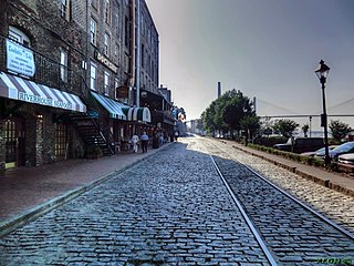
River Street is a commercial street and promenade in Savannah, Georgia, United States. It runs along the southern edge of the Savannah River for 2 miles (3.2 km), from the merging of North and East Lathrop Avenues in the west to East Bay Street in the east. Its most well-known section runs from the Talmadge Memorial Bridge, then below City Hall and Yamacraw Bluff, to its eastern terminus. It is West River Street up to where the Hyatt Regency Savannah spans it. It is here, around 40 feet (12 m) below Bay Street, that it becomes East River Street. The street is one-way (westbound) from Martin Luther King Jr. Boulevard.
Michael Cash (1833–1880) was an Irish stonemason who was active in the mid-19th century. His most notable work is the Factors Walk retaining wall in Savannah, Georgia, which was built between 1855 and 1869.

Oglethorpe Square is one of the 22 squares of Savannah, Georgia, United States. It is located in the second row of the city's five rows of squares, on Abercorn Street and East President Street, and was laid out in 1742. It is south of Reynolds Square, west of Columbia Square, north of Colonial Park Cemetery and east of Wright Square. The oldest building on the square is the Owens–Thomas House, at 124 Abercorn Street, which dates 1819.

Sholl & Fay was the architectural firm of Charles Sholl and Calvin Fay which was active in the 19th century. The partnership existed between 1852 and 1857. They were responsible for the renovations of the City Exchange, Savannah Medical College and several Italianate buildings in Savannah, Georgia, where they were based.

Lower Stoddard Range is a historic range of buildings in Savannah, Georgia, United States. Located in Savannah's Historic District, the addresses of some of the properties are East Bay Street, above Factors Walk, while others solely utilize the former King Cotton warehouses on River Street. As of February 2022, the businesses occupying the ground floor of the River Street elevation are: Boar's Head Grill & Tavern, Savannah's Candy Kitchen, Gallery 209 and Christmas on the River.

Upper Stoddard Range is a historic range of buildings in Savannah, Georgia, United States. Located in Savannah's Historic District, the addresses of some of the properties are East Bay Street, above Factors Walk, while others solely utilize the former King Cotton warehouses on River Street. As of February 2022, the businesses occupying the ground floor of the River Street elevation are: Washed Ashore, Vic's River Grill, Vic's on the River, Sona's Souvenir & Gifts, The Warehouse Bar & Grille and River Street Sweets Candy Store.

The Thomas Gamble Building, formerly known as the Eugene Kelly Stores, Kelly's Block and Kelly's Building, is a historic building in Savannah, Georgia, United States. Located in Savannah's Historic District, between Upper Stoddard Range to the east, Savannah City Hall to the south and the Hyatt Regency Savannah to the west, the addresses of some of the properties are East Bay Street, above Factors Walk, while Olympia Cafe occupies the former King Cotton warehouses on the River Street elevation.
Archibald Smith Stores is a historic building in Savannah, Georgia, United States. Located in Savannah's Historic District, the addresses of some of the properties are East Bay Street, above Factors Walk, while others solely utilize the former King Cotton warehouses on River Street. The building was constructed in 1810, making it the oldest intact structure on East River Street. Due to the building's height, it is at this point that Factors Walk changes from being single-level to become two levels.
Claghorn and Cunningham Range is a historic range of buildings in Savannah, Georgia, United States. Located in Savannah's Historic District, the addresses of some of the properties are East Bay Street, above Factors Walk, while others solely utilize the former King Cotton warehouses on River Street. As of February 2022, the businesses occupying the ground floor of the River Street elevation are True Grits and Wet Willie's.

Jones and Telfair Range, also known as Jones' Upper Range, is a historic range of buildings in Savannah, Georgia, United States. Located in Savannah's Historic District, the Cotton Sail Hotel, a Hilton Hotels property, occupies the West Bay Street elevation, above Factors Walk, while others solely utilize the former King Cotton warehouses on River Street. As of February 2022, the businesses occupying the ground floor of the River Street elevation are Whispers, the Cotton Sail Hotel, River House Seafood and Fiddlers' Crab House. Kevin Barry's Pub closed in 2020 after nearly forty years in business.
Bay Street is a prominent street in Savannah, Georgia, United States. It runs for about 3.65 miles (5.87 km) from Main Street in the west to General McIntosh Boulevard in the east. The section passing through Savannah's downtown, between the Bay Street Viaduct in the west and General McIntosh Boulevard in the east, is around 1.2 miles (1.9 km) long.

Abercorn Street is a prominent street in Savannah, Georgia, United States. Located between Drayton Street to the west and Lincoln Street to the east, it runs for about 7.8 miles (12.6 km) from East Bay Street in the north to Harry S. Truman Parkway in the south. It is concurrent with SR 204 from 37th Street south. The street is named for James Hamilton, 6th Earl of Abercorn, a financial benefactor of the Georgia colony. Its northern section passes through the Savannah Historic District, a National Historic Landmark District.

Drayton Street is a prominent street in Savannah, Georgia, United States. Located between Bull Street to the west and Abercorn Street to the east, it runs for about 2 miles (3.2 km) from East Bay Street in the north to East Victory Drive in the south. It is named for Ann Drayton, a member of a noted family in Charleston, South Carolina, who had lent four sawyers to assist colonists in building one of the first homes in Savannah. The street is one-way (northbound). Its northern section passes through the Savannah Historic District, a National Historic Landmark District.

Lincoln Street is a prominent street in Savannah, Georgia, United States. Located between Abercorn Street to the west and Habersham Street to the east, it runs for about 2 miles (3.2 km) from East Bay Street in the north to East Victory Drive in the south. It is named for Benjamin Lincoln, a Revolutionary War hero. The street is one-way (northbound) south of Colonial Park Cemetery, which interrupts it between East Oglethorpe Avenue and East Perry Lane. The Lincoln Street Ramp leads down through Factors Walk to River Street and the Savannah River waterfront. Its northern section passes through the Savannah Historic District, a National Historic Landmark District.

Barnard Street is a prominent street in Savannah, Georgia, United States. Located between Jefferson Street to the west and Whitaker Street to the east, it runs for about 2.54 miles (4.09 km) from West Bay Street in the north to West 52nd Street in the south. The street is named for Sir John Barnard, Lord Mayor of London in 1737 and 1740. Its northern section passes through the Savannah Historic District, a National Historic Landmark District.

Jefferson Street is a prominent street in Savannah, Georgia, United States. Located between Montgomery Street to the west and Barnard Street to the east, it runs for about 2 miles (3.2 km) from West Bay Street in the north to West 42nd Street in the south. Its course was interrupted by around 0.14 miles (0.23 km) by the construction of the Savannah Civic Center in 1974. The street is named for Thomas Jefferson, third president of the United States. Its northern section passes through the Savannah Historic District, a National Historic Landmark District.

Perry Street is a prominent street in Savannah, Georgia, United States. Located between Hull Street to the north and Liberty Street to the south, it runs for about 0.46 miles (0.74 km) from Barnard Street in the west to East Broad Street in the east. It is interrupted by Colonial Park Cemetery from Abercorn Street to Habersham Street. Originally known only as Perry Street singular, its addresses are now split between "West Perry Street" and "East Perry Street", the transition occurring at Bull Street in the center of the downtown area. It is named for commodore Oliver Hazard Perry, who served in the War of 1812. The street is entirely within Savannah Historic District, a National Historic Landmark District.
Tattnall Street is a prominent street in Savannah, Georgia, United States. Located between Jefferson Street to the west and Barnard Street to the east, it runs for about 0.53 miles (0.85 km) from West Liberty Street in the north to West Gwinnett Street in the south. It passes through the Savannah Historic District, a National Historic Landmark District.

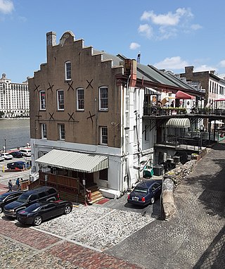
Boar's Head Grill & Tavern is a restaurant and bar in Savannah, Georgia, United States. Located on the Lincoln Street ramp, at River Street, the restaurant, established in 1959, occupies the first floor of the Lower Stoddard Range former King Cotton warehouse dating to 1858. It is the oldest restaurant on River Street.


