Fail Loch

Last updated

Fail Loch
Site of Fail Loch.JPG
The site of Fail Loch
South Ayrshire UK relief location map.jpg
Red pog.svg
Fail Loch
Location Tarbolton, South Ayrshire, Scotland
Coordinates Coordinates: 55°31′53.8″N4°29′42.5″W / 55.531611°N 4.495139°W / 55.531611; -4.495139
Type Drained freshwater loch
Primary inflows Townend Burn and the Mill Burn
Primary outflows Water of Fail
Basin  countriesScotland
Islands One
Settlements Tarbolton

Fail Loch or Faile Loch was situated in a low-lying area near the old monastery of Fail in the Parish of Tarbolton, South Ayrshire, Scotland. The old Lochlea Loch lies nearby and its waters still feed into Fail Loch via the Mill Burn.

Contents

History

The loch is recorded as 'Valle' in 1307, [1] and 'Feil' [2] in the 17th century. Feill' (1732), 'Faill' or 'Ffele' are further names recorded for the site. [3] Paterson states that the loch once surrounded the Fail Monastery so that it sat on an island. [4] The surviving portion of the seasonal loch is located to the north of the old monastery site. [5]

In 1504 it is recorded that turf and masses of earth on land belonging to the House of Failford were used for repairing a breakout of Fail Loch and lade to the north and west where the border with the lands of the Abbot of Melrose lay. [6]

In Robert Burns's day Fail Loch was one of three plains that were flooded in winter to supply power for the mill that only worked once the harvest was gathered. It was a haunt for otters and kingfishers amongst other wildlife. [7]

Shaw relates in the 1950s that Lochlee, Fail Loch and Tarbolton Loch are no longer so full of water as when they were required to supply water for the meal mills, and gave good skating and curling in a hard winter. They are now to a large extent drained away, but are still the haunt of snipe, goose, duck, and swan. [8]

The Water of Fail near Fail Castle Cottage Water of Fail at Fail.JPG
The Water of Fail near Fail Castle Cottage

Fail Mill

The Duke of Portland abolished thirlage in mid-19th century, making Millburn Mill, and its head of water, Lochlea, redundant [9] [10] resulting in active attempts at drainage at both Fail and Lochlea causing their effective demise circa 1840. Much of the loch lands of Fail Loch became part of the fields of the surrounding farms and properties, such as Mosside, Lilylaw, Adamhill, and Boghead, however a portion remained prone to seasonal flooding.

The waters of the Townend and Mill Burns still contribute to the flow towards the old Fail Mill that stood on the rivulet, known from this point on, as the Water of Fail and survived into the 20th century. Much of the surrounding lands in the area, originally belonged to the monks from Fail Monastery. [9] The old Monk's Road forms a boundary on the east side of the old loch.

William Muir was the tenant of the Mill of Fail at the time of Robert Burns. [11]

The OS maps show the presence of a dam and mill pond which would have negated the need for the existence of the loch as a head of water for the mill.

In 1840 three cinerary urns were found at Fail Mill and were donated to the Mechanics Museum in Ayr by Mr Andrew of Fail Mill. [12]

Drainage

Although the loch's drainage may have begun in the 18th century when Alexander Montgomerie, 10th Earl of Eglinton, was pursuing a number of agricultural improvements on his extensive estates and other landowners followed his example, further drainage work may have taken place in the 1740s as part of the improvements undertaken to provide employment for Irish estate workers during the Irish potato famines of the 1740s and the mid 19th centuries. Many drainage schemes also date to the end of World War I when many soldiers returned en masse to civilian life. [13]

Cartographic evidence

Blaeu's map of 1654, dating from Timothy Pont's survey of circa 1604, clearly shows and names the loch and indicates that it was somewhat larger than Lochlea Loch. [14] Roy's map of 1747 shows no loch present. [15] Thomson map of 1832 does not record a loch, although Loch Brown and Lochlea Loch are marked. [16]

The 19th century Ordnance Survey maps show the site as 'Fail Loch' and state that it is liable to flooding, [17] and the drainage remains inadequate and the area dominated by marsh plants. [18] Paterson records that part of Fail Loch remains in the 1860s. [19]

Scotland relief location map.jpg
Red pog.svg
Loch of Fail
Previous location of Fail Loch, South Ayrshire

Micro-history

The Monk's Road. Monk's Road, Fail.JPG
The Monk's Road.

Fail Loch is the site of a wildfowl Wetland Bird Survey (WEBS) count. [20] Fail Loch, a Scottish Wildlife Trust designated site is also important as a wetland with over 125 plant species recorded.

Tarbolton Curling Club used Loch Fail in the 19th century, showing that it was prone to winter flooding at that time. [21] [22]

See also

Related Research Articles

<span class="mw-page-title-main">Fail Monastery</span> Former monastery in Ayrshire, Scotland

Fail Monastery, occasionally known as Failford Abbey, had a dedication to 'Saint Mary', and was located at Fail on the bank of the Water of Fail, Parish of Tarbolton near the town of Tarbolton, South Ayrshire. Most of the remaining monastery ruins were removed in 1952. The official and rarely used title was House of the Holy Trinity of Failford or the Ministry of Failford.

<span class="mw-page-title-main">Hill of Beith Castle</span>

The old Barony and castle, fortalice, or tower house of Hill of Beith lay in the feudal Regality of Kilwinning, within the Baillerie of Cunninghame, and the Sherrifdom of Ayr, now the Parish of Beith, North Ayrshire, Scotland.

<span class="mw-page-title-main">Lambroughton Loch</span> Body of water

Lambroughton Loch or Wheatrig Loch was situated in a low-lying area between the farms and dwellings of Hillhead, Lambroughton, Wheatrig, Titwood and Lochridge mainly in the Parish of Dreghorn, North Ayrshire. The loch was mainly fed by the Lochridge Burn, the Garrier Burn and surface runoff, such as from the old rig and furrows indicated by Roy's maps of the mid-18th century. The loch outflow was via the Lochridge Burn that runs into the Garrier Burn, passes the site of the old Lochend habitation and into the Bracken Burn near Little Alton. The rivulet or watercourse is known as the Garrier Burn beyond this point.

<span class="mw-page-title-main">Lochlea, South Ayrshire</span> Body of water

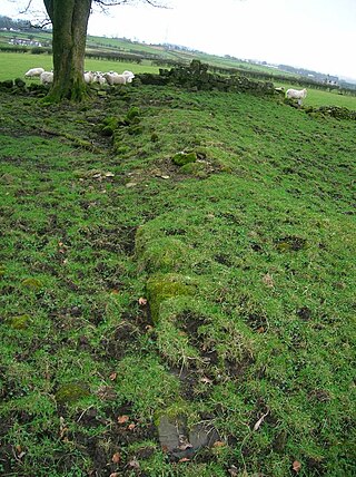
Lochlea or Lochlie was situated in a low-lying area between the farms and dwellings of Lochlea and Lochside in the Parish of Tarbolton, South Ayrshire, Scotland. The loch was natural, sitting in a hollow created by glaciation. The loch waters ultimately drained via Fail Loch, the Mill Burn, and the Water of Fail. It is well-documented due to the presence of a crannog that was excavated and documented circa 1878, and its association with the poet Robert Burns, who lived here for several years whilst his father was the tenant. Lochlea lies 2+12 miles northeast of Tarbolton, and just over three miles northwest of Mauchline.

<span class="mw-page-title-main">Buiston Loch</span> An occasional lake in Ayrshire, Scotland

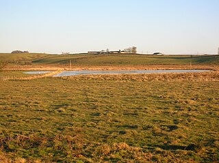
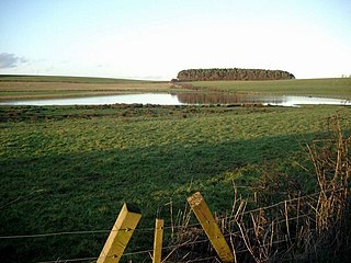
Buiston Loch, also known as Buston, Biston, and Mid Buiston was situated in the mid-Ayrshire clayland at an altitude of 90 m OD. The loch was natural, sitting in a hollow created by glaciation. The loch waters drained via the Garrier Burn that joins the Bracken and Lochridge Burns before joining the River Irvine.

<span class="mw-page-title-main">Halket Loch</span> Body of water

Halket Loch' also known as Halkhead or Halketh, was situated in the mid-Ayrshire clayland near Lugton. It is visible as a surface depression in pastureland, sometimes partially flooded, situated in a low-lying area close to farms and dwellings of East, North and Middle Halket and Craighead in the Parish of Dunlop, East Ayrshire, Scotland. The loch was natural, sitting in a hollow created by glaciation. The loch waters drained via the Glazert Water that joins the Annick Water.

<span class="mw-page-title-main">Loch Brown</span> Body of water

Loch Brown, also known in Scots as Loch Broun, Broon or Broom, was situated in a kettle hole in the mid-Ayrshire clayland near Crosshands. It is nowadays (2011) visible as a surface depression in pastureland, partially flooded, situated in a low-lying area close to farms and dwellings of Skeoch, Dalsangan, Ladebrae, Lochhill, and Crosshands, mainly in the Parish of Mauchline and partly in Craigie, East Ayrshire, Scotland. Duveloch is an old name for the loch and this may derive from the Gaelic Dubh, meaning black or dark loch.

<span class="mw-page-title-main">Littlestane Loch</span> Former lake in Irvine, Scotland

Littlestane Loch, was situated in the mid-Ayrshire clayland near Stanecastle, Irvine, North Ayrshire, Scotland. It is nowadays (2011) only visible as an area of permanent water in the Scottish Wildlife Trust Sourlie Nature Reserve. The loch was natural, sitting in a hollow created by glaciation. The loch waters outflow was via the Red Burn that flows into the River Garnock. The site of Littlestane Loch site is partly built over and much of the site is now public open space lying within the Parish of Girdle Toll.

<span class="mw-page-title-main">Helenton Loch</span> Body of water

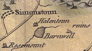
Helenton Loch was situated in a low lying area between the farms and dwellings of Helentongate, Mains, and Burnbank in the Parish of Symington, South Ayrshire, Scotland. The loch was natural, sitting in a hollow, a kettle hole, created by glaciation. The loch waters ultimately drained via the Pow Burn. Helenton Hill is a prominent landmark to the west of the old loch site. The nearby lands of Rosemount were in 1549 known as 'Goldring' and were the property of the Schaws of Sornbeg.

<span class="mw-page-title-main">Hessilhead Loch</span> Body of water

Hessilhead Loch or Hazelhead Loch was situated in a low-lying area near the old Castle of Hessilhead in the Parish of Beith, North Ayrshire, Scotland. The old loch, used in the defence of the castle, was probably infilled when the castle ruins were landscaped in the 19th century.

<span class="mw-page-title-main">Blae Loch (Beith)</span> A lake in Ayrshire, Scotland

The Blae Loch is a small freshwater loch situated in a hollow in a low-lying area beneath Blaelochhead Hill in the Parish of Beith, North Ayrshire, Scotland.

<span class="mw-page-title-main">Galrigs Loch (South Ayrshire)</span> Body of water

The Galrigs Loch was a substantial freshwater loch situated in low lying area between Newfield and Dundonald in South Ayrshire, Scotland. It was drained in the early 18th century.

<span class="mw-page-title-main">Clevens Loch, Ayrshire</span> Body of water

Clevens Loch was a substantial freshwater loch situated in a low-lying area below Clevance Farm and Langholm Farm in Dundonald parish, South Ayrshire, Scotland.

<span class="mw-page-title-main">Loch of Trabboch</span> Body of water

The Loch of Trabboch or Dalrympleston Loch (NS440211) was situated in a low-lying area below the old Castle of Trabboch, once held by the Boyd family in the Parish of Stair, East Ayrshire, Scotland.

<span class="mw-page-title-main">Loch of Stair</span> Body of water

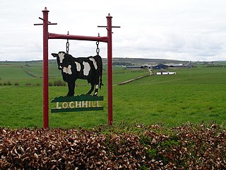
The Loch of Stair was a typical Ayrshire post-glacial 'Kettle Hole', situated in a low-lying area below the farm of Loch Hill, in the Parish of Stair, East Ayrshire, Scotland. This freshwater loch was drained in the 19th century, leaving a wetland area which still periodically floods.

<span class="mw-page-title-main">Martnaham Loch</span> Body of water

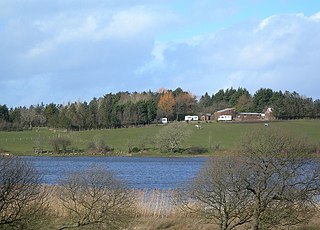
Martnaham Loch is a freshwater loch lying across the border between East and South Ayrshire Council Areas, two kilometres from Coylton, in the parishes of Coylton and Dalrymple, three miles from Ayr. The loch lies along an axis from northeast to southwest. The remains of a castle lie on a possibly artificial islet within the loch. The Campbells of Loudoun once held the lands, followed by the Kennedys of Cassillis.

<span class="mw-page-title-main">Lindston Loch, South Ayrshire</span> Body of water

Lindston Loch was a small freshwater loch situated within a glacial 'kettle hole.' The loch lies in the South Ayrshire Council Area, Parish of Dalrymple, Scotland.

<span class="mw-page-title-main">Whitehill Loch</span> Body of water

Whitehill Loch, previously known as Hillhouse Loch was a freshwater loch in the East Ayrshire Council Area, now drained, near Galston, in the Parish of Riccarton, lying in a glacial Kettle Hole.

<span class="mw-page-title-main">Black Loch (New Cumnock)</span> Body of water

Black Loch is a freshwater loch, named from its dark waters, situated in the East Ayrshire Council Area, between Cumnock and New Cumnock, lying in a glacial Kettle Hole mainly within the Parish of New Cumnock, a small portion protruding into Old Cumnock Parish. It is said to be one of only two lochs or lakes in the world that have outflows running to two separate destinations. The 'Runner' is a deep and broad ditch that was dug many years back to link the three lochs of Lowes, Black, and Creoch.

<span class="mw-page-title-main">Haugh, East Ayrshire</span> Human settlement in Scotland

Haugh or The Haugh is a small village or hamlet in East Ayrshire, Parish of Mauchline, Scotland. The habitation is situated about two and a half miles downstream from Catrine, on the north bank of the River Ayr. The River Ayr Way runs through the village.

References

Notes
  1. Lochlea Retrieved : 2011-02-16
  2. Blaeu's Map Retrieved : 2011-02-016
  3. Paterson, V.II, Page 756
  4. Paterson, Page 760
  5. Love, Pages 209-210
  6. Dillon, p.99
  7. Lowe, David (1904). Burns Passionate Pilgrimage or Tait's Indictment of the Poet. Frederick W.Wilson & Co. p. 50.
  8. Smith, Page 60
  9. 1 2 Paterson, V.II. Page 751
  10. Arch Hist Coll, Page 87
  11. The Book of Robert Burns. Accessed : 2010-07-02
  12. Dillon, p.117
  13. MacIntosh, Pages 37 & 39
  14. Blaeu's Map Retrieved : 2011-02-16
  15. Roy's Map Retrieved : 2011-02-16
  16. Thomson's Map Retrieved : 2011-02-16
  17. NLS Maps Archived April 11, 2011, at the Wayback Machine Retrieved : 2011-02-16
  18. Google Maps Retrieved : 2011-02-16
  19. Paterson, Page 255
  20. Fail Loch WEBS Retrieved : 2011-02-16
  21. Tarbolton CC Retrieved : 2011-02-16
  22. Curling Pond Sites [ permanent dead link ] Retrieved : 2011-03-18
Sources
  1. Adamson, Archibald R. (1879). Rambles through the Land of Burns. Kilmarnock : Dunlop & Drennan.
  2. Love, Dane (2003). Ayrshire : Discovering a County. Ayr : Fort Publishing. ISBN   0-9544461-1-9.
  3. MacIntosh, Donald (2006). Travels in Galloway. Glasgow : Neil Wilson. ISBN   1-897784-92-9.
  4. Paterson, James (1863–66). History of the Counties of Ayr and Wigton. V. 1 - Part 1 - Kyle. Edinburgh: J. Stillie.
  5. Shaw, James Edward (1953). Ayrshire 1745-1950. Edinburgh : Oliver & Boyd.