
The Verde River is a major tributary of the Salt River in the U.S. state of Arizona. It is about 170 miles (270 km) long and carries a mean flow of 602 cubic feet per second (17.0 m3/s) at its mouth. It is one of the largest perennial streams in Arizona.

Saguaro Lake is the fourth reservoir on the Salt River, formed by the Stewart Mountain Dam in the U.S. state of Arizona. The lake is off State Route 87, about halfway between Phoenix and the ghost town of Sunflower. The dammed end of the lake is at 33.5656°N 111.5361°W, at an elevation of 1,506 feet (459 m).

Luna Lake is a natural body of water that covers approximately 75 acres (0.30 km2) of land. It is located about three miles (5 km) southeast of Alpine, Arizona, at the elevation of 7,890 ft (2,400 m), and is the centerpiece of the Luna Lake Wildlife Area.

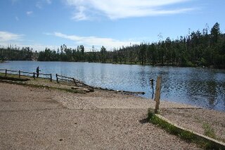
Knoll Lake is part of the Blue Ridge Ranger District of the Coconino National Forest. It gets its name from a rocky island located in the middle of the lake. Knoll Lake is located in Leonard Canyon, Arizona, along the Mogollon Rim. This 75-acre (30 ha) lake is located at 7,340 feet (2,240 m) elevation and is closed to visitors in the winter months. Bald eagles may be seen during the winter months if the roads are open late into the season. The facilities are maintained by Coconino National Forest division of the USDA Forest Service.
Chevelon Canyon Lake is a small reservoir located in northern Arizona, about 28 mi (45 km) northwest of the town of Heber. It is one in a series of small, canyon-bound lakes located on the Mogollon Rim, collectively referred to as the Rim Lakes. It is said to be among the most difficult to access in the region. It is also the second reservoir on Chevelon Creek, downstream from Woods Canyon Lake. The facilities are maintained by Apache–Sitgreaves National Forests division of the USDA Forest Service.
Woods Canyon Lake is a small lake located in northern Arizona, United States, about 30 mi (48 km) east of the city of Payson. It is one in a series of small, canyon-bound lakes located on the Mogollon Rim, collectively referred to as the Rim Lakes. It is among the more developed and accessible of the Rim Lakes. It is also the first reservoir on Chevelon Creek, upstream from Chevelon Canyon Lake.
Bear Canyon Lake is a lake built by Arizona Game and Fish Department for angler recreation. The facilities are maintained by Apache-Sitgreaves National Forest division of the USDA Forest Service.
Becker Lake is a reservoir managed as a trophy trout lake. Located near Springerville, Arizona, Becker Lake is part of the 622-acre (252 ha) Becker Lake Wildlife Area. Built around the year 1880, it is one of the oldest reservoirs in the White Mountains. The Arizona Game and Fish Department acquired the lake and property around it in 1973. The lake is located at 6,910 feet (2,110 m).
Black Canyon Lake is a lake in Navajo County, Arizona, United States.

The Black River is a 114-mile-long (183 km) river in the White Mountains of the U.S. state of Arizona. It forms southwest of Alpine and flows southwest then northwest to meet the White River west of Fort Apache. The merged streams form the Salt River, a major tributary of the Gila River.
Carnero Lake is a high elevation shallow lake in Apache County, Arizona. Built in 1979, the lake quickly became popular with anglers, to the dismay of downstream water users. Because of the dispute, the Arizona Game and Fish discontinued stocking for many years. In 1999, the Arizona Game and Fish has acquired a major share of the water rights, setting the stage for a new and vigorous trout fishery.
Concho Lake is an irrigation reservoir situated in the town of Concho, in the eastern Arizona grasslands at 6,300 feet (1,900 m). Much of the surrounding land is privately owned; the rest is owned by the Bureau of Land Management, but is managed for sport fisheries and wildlife resources by the Arizona Game and Fish.
Haigler Creek is located in the Mogollon Rim area of the state of Arizona. The closest town, Young, is 14 miles (23 km) away. The facilities are maintained by Tonto National Forest division of the USDA Forest Service.
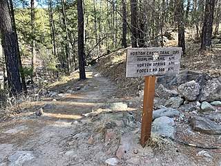
Horton Creek is located in the Mogollon Rim area of the state of Arizona. The closest town Payson is 20 miles (32 km) away. The facilities are maintained by Tonto National Forest division of the USDA Forest Service.
Willow Beach is located on the Arizona side of the Colorado River between Lake Mead and Lake Mohave. Both Lake Mead and Lake Mohave are part of the Lake Mead National Recreation Area administered by the U.S. National Park Service.

Tonto Creek is a 72.5-mile-long (116.7 km) stream located in the Mogollon Rim area of the state of Arizona on the north edge of the Tonto National Forest. The closest town, Payson, is 18 miles (29 km) away. Tonto Creek is a stream that flows year round, starting just below the Mogollon Rim, at the northern edge of Tonto National Forest. The creek continues its descent through the Hellsgate Wilderness area and eventually into a wide valley in the Sonoran Desert. It continues through the desert and into the Salt River within the north end of Theodore Roosevelt Lake. The facilities are maintained by Tonto National Forest division of the USDA Forest Service.
The Cluff Ranch Ponds are located in the Cluff Ranch Wildlife Area at the base of the Pinaleno Mountains in southeastern Arizona. The town of Pima is 5 miles (8.0 km) away, and the city of Safford is 7 miles (11 km) away. The facilities are maintained by the Arizona Game and Fish Department.
Peña Blanca Lake is a reservoir in Arizona, United States, located 18 miles (29 km) northwest of Nogales. The facilities are maintained by the Coronado National Forest division of the USDA Forest Service. The lake was created in 1957 by the Arizona Game and Fish Department.Back then this lake was known for a plush resort that was located there. In 2008, the lake was closed to clean mercury contamination within the sediment, thought to be from old mines in the area. Also the former plush resort was removed as well. The lake was reopened in August 2009. In 2013, an Arizona Department of Environmental Quality report showed that mercury levels were similar to those before the lake was drained and dredged. One potential cause for the high mercury could be naturally occurring mercury seeping through the faults or a spring in the lake, though these claims are still under investigation.

Fool Hollow Lake is a public lake located in Navajo County, Arizona, near the city of Show Low. The lake is operated by the Arizona State Parks Department, and consists of 150 acres (61 ha), with an average depth of 23 feet (7.0 m) together with a variety of fish species.
Willow Springs Lake is a cold water lake located on top of the Mogollon Rim in northern Arizona, about 23 mi (37 km) east of the city of Payson in the Apache-Sitgreaves National Forests, immediately adjacent to SR 260. It is a canyon-bound lake located on the Mogollon Rim, and is part of the collectivity known as the Rim Lakes. It can be found upstream from Chevelon Canyon Lake. The facilities are maintained by Apache-Sitgreaves National Forests division of the USDA Forest Service.
