Fairy Bower Beach

Last updated

Oceanides or Sea Nymphs sculptures at Fairy Bower FairyBower.JPG
Oceanides or Sea Nymphs sculptures at Fairy Bower

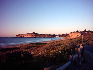
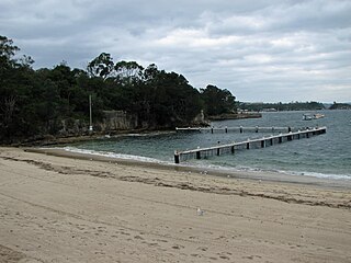
Fairy Bower is a beach in the Manly area of Sydney, New South Wales, Australia.

Manly, New South Wales Suburb of Sydney, New South Wales, Australia

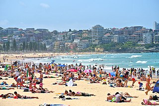
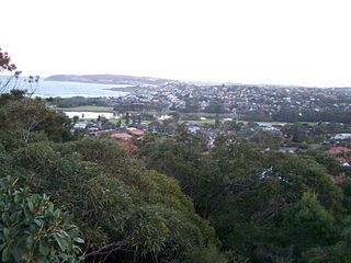
Manly is a beach-side suburb of northern Sydney, in the state of New South Wales, Australia. It is 17 kilometres (11 mi) north-east of the Sydney central business district and is currently one of the three administrative centres of the local government area of Northern Beaches Council. Manly has a long-standing reputation as a tourist destination, owing to its attractive setting on the Pacific Ocean and easy accessibility by ferry.

Sydney State capital of New South Wales and most populous city in Australia and Oceania

Sydney is the state capital of New South Wales and the most populous city in Australia and Oceania. Located on Australia's east coast, the metropolis surrounds Port Jackson and extends about 70 km (43.5 mi) on its periphery towards the Blue Mountains to the west, Hawkesbury to the north, the Royal National Park to the south and Macarthur to the south-west. Sydney is made up of 658 suburbs, 40 local government areas and 15 contiguous regions. Residents of the city are known as "Sydneysiders". As of June 2017, Sydney's estimated metropolitan population was 5,230,330 and is home to approximately 65% of the state's population.

New South Wales State of Australia

New South Wales is a state on the east coast of Australia. It borders Queensland to the north, Victoria to the south, and South Australia to the west. Its coast borders the Tasman Sea to the east. The Australian Capital Territory is an enclave within the state. New South Wales' state capital is Sydney, which is also Australia's most populous city. In September 2018, the population of New South Wales was over 8 million, making it Australia's most populous state. Just under two-thirds of the state's population, 5.1 million, live in the Greater Sydney area. Inhabitants of New South Wales are referred to as New South Welshmen.

Fairy Bower is an affluent area, located close to Shelly Beach (Manly) and North Head. The International School of Management Sydney (ICMS) and the Bower Surf Spot are located here. A scenic walk links Manly Beach to Fairy Bower and Shelly Beach. Jan Warhurst, a local diver, is famed for discovering a number of new species of catfish in the marine park.

Shelly Beach (Manly) beach in Manly, New South Wales, Australia

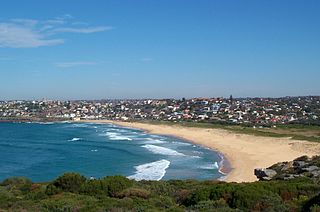
Shelly Beach is a beach located in Manly, a suburb of Sydney, New South Wales, Australia. It is adjacent to North Head and Fairy Bower. Shelly Beach is a western facing beach on the eastern coast of Australia. Shelly Beach is part of the no take Cabbage Tree Bay Aquatic Reserve.

Sydney Heads headlands around Sydney Harbour

The Sydney Heads are a series of headlands that form the 2 km (1.2 mi) wide entrance to Sydney Harbour in Sydney, New South Wales, Australia. North Head and Quarantine Head are to the north; South Head and Dunbar Head are to the south; and Middle Head, Georges Head, and Chowder Head are to the west and within the harbour. The Heads are contained within the Sydney Harbour National Park.

Dusky Whaler sharks are seen regularly by divers in this area. [1]

Dusky shark species of fish

The dusky shark is a species of requiem shark, in the family Carcharhinidae, occurring in tropical and warm-temperate continental seas worldwide. A generalist apex predator, the dusky shark can be found from the coast to the outer continental shelf and adjacent pelagic waters, and has been recorded from a depth of 400 m (1,300 ft). Populations migrate seasonally towards the poles in the summer and towards the equator in the winter, traveling hundreds to thousands of kilometers. One of the largest members of its genus, the dusky shark reaches 4.2 m (14 ft) in length and 347 kg (765 lb) in weight. It has a slender, streamlined body and can be identified by its short round snout, long sickle-shaped pectoral fins, ridge between the first and second dorsal fins, and faintly marked fins.

Related Research Articles

Balgowlah, New South Wales Suburb of Sydney, New South Wales, Australia

Balgowlah is a suburb of northern Sydney, in the state of New South Wales, Australia. Balgowlah is located 12 kilometres north-east of the Sydney central business district in the local government area of Northern Beaches Council, in the Northern Beaches region. Balgowlah shares the postcode 2093 with the adjacent suburbs of Manly Vale, Balgowlah Heights and North Balgowlah.

Dobroyd Head is a point or headland in the Northern Beaches local government area, in the suburb of Balgowlah Heights, New South Wales, Australia. It is part of the Sydney Harbour National Park, which contains examples of ecosystems at risk such as coastal heath. Tania Park is located to the immediate north-east, and contains the 2MWM 90.3 transmitter. There is a lookout sited on the headland named after Arabanoo, the first Aboriginal man to live among European settlers who was captured in Manly Cove in 1788.

Balgowlah Heights is a suburb of northern Sydney, in the state of New South Wales, Australia 11 kilometres north-east of the Sydney central business district in the local government area of Northern Beaches Council, in the Northern Beaches region. Balgowlah Heights shares the postcode 2093 with the adjacent Balgowlah and North Balgowlah.

Manly Beach beach situated in Sydneys Northern Beaches

Manly Beach is a beach situated among the Northern Beaches of Sydney, Australia in Manly, New South Wales. From north to south, the three main sections are Queenscliff, North Steyne, and South Steyne.

Mona Vale, New South Wales Suburb of Sydney, New South Wales, Australia

Mona Vale is a suburb of Sydney, in the state of New South Wales, Australia. It is located 28 kilometres north of the Sydney central business district, in an area known as the Northern Beaches. Formerly the administrative centre of Pittwater Council, it is now located in the local government area of Northern Beaches Council.

Division of Warringah Australian federal electoral division

The Division of Warringah is an Australian electoral division in the state of New South Wales. The division is named after the Warringah area of Sydney, which itself is named by an Aboriginal Australian word which translates into English as "rain", "waves" or "sea". The Division was proclaimed at the redistribution of 13 September 1922, and was first contested at the 1922 federal election.

Queenscliff, New South Wales Suburb of Sydney, New South Wales, Australia

Queenscliff is a suburb of northern Sydney, in the state of New South Wales, Australia. Queenscliff is located 16 kilometres north-east of the Sydney central business district, in the local government area of Northern Beaches Council and is part of the Northern Beaches region.

North Manly is a suburb of northern Sydney, in the state of New South Wales, Australia 17 kilometres north-east of the Sydney central business district in the local government area of Northern Beaches Council. It is part of the Northern Beaches region.

North Curl Curl, New South Wales Suburb of Sydney, New South Wales, Australia

North Curl Curl is a suburb in northern Sydney, in the state of New South Wales, Australia 19 kilometres north-east of the Sydney central business district, in the local government area of Northern Beaches Council. It is part of the Northern Beaches region.

Curl Curl Suburb of Sydney, New South Wales, Australia

Curl Curl is a suburb of northern Sydney in the state of New South Wales, Australia, 18 kilometres (11 mi) north-east of the Sydney central business district, in the local government area of Northern Beaches Council. It is part of the Northern Beaches region.

Fairlight, New South Wales Suburb of Sydney, New South Wales, Australia

Fairlight is a suburb of northern Sydney, in the state of New South Wales, Australia. Fairlight is located 13 kilometres north-east of the Sydney central business district in the local government area of Northern Beaches Council and is part of the Northern Beaches region.

Fairy Bower may refer to:

Shelly Beach, Central Coast New South Wales Suburb of Central Coast, New South Wales, Australia

Shelly Beach is a coastal suburb of the Central Coast region of New South Wales, Australia, located east of Tuggerah Lake and bordering the Pacific Ocean south of The Entrance. It is part of the Central Coast Council local government area. It is 66 km south of Newcastle & 93 km north of Sydney. Shelly Beach is considered one of the most popular surfing beaches on the Central Coast.

Currawong Beach Suburb of Sydney, New South Wales, Australia

Currawong Beach is a suburb in northern Sydney, in the state of New South Wales, Australia. Currawong Beach is 42 kilometres (26 mi) north of the Sydney central business district, in the local government area of Northern Beaches Council.

Freshwater Beach

Freshwater Beach is a beach located in Freshwater, New South Wales, a suburb of Sydney, Australia. Freshwater Beach is the first beach north of Manly, New South Wales, on the Peninsula. The beach is flanked by a headland at each end and can produce excellent surf. There is a large rock pool at the northern end. The beach is patrolled by lifeguards and has its own surf lifesaving club.

Little Manly Beach

Little Manly Beach is situated on the northern shore of Sydney Harbour, within Little Manly Cove, which is separated from the larger Manly Cove by Manly Point.

Bare Creek river in Australia

Bare Creek, a watercourse that is part of the Middle Harbour catchment of Sydney Harbour, is located in the northern beaches region of Sydney, New South Wales, Australia.

References

The Dictionary of Sydney is a digital humanities project to produce an online, expert-written encyclopedia of all aspects of the history of Sydney.

Creative Commons license license allowing free use of a work

A Creative Commons (CC) license is one of several public copyright licenses that enable the free distribution of an otherwise copyrighted "work". A CC license is used when an author wants to give other people the right to share, use, and build upon a work that they have created. CC provides an author flexibility and protects the people who use or redistribute an author's work from concerns of copyright infringement as long as they abide by the conditions that are specified in the license by which the author distributes the work.

Coordinates: 33°47′55″S151°17′34″E / 33.79861°S 151.29278°E / -33.79861; 151.29278

Geographic coordinate system Coordinate system

A geographic coordinate system is a coordinate system that enables every location on Earth to be specified by a set of numbers, letters or symbols. The coordinates are often chosen such that one of the numbers represents a vertical position and two or three of the numbers represent a horizontal position; alternatively, a geographic position may be expressed in a combined three-dimensional Cartesian vector. A common choice of coordinates is latitude, longitude and elevation. To specify a location on a plane requires a map projection.