The University Ground was a test cricket stadium in Lucknow, India.
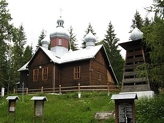
Matejovce nad Hornádom is a village and municipality in the Spišská Nová Ves District in the Košice Region of central-eastern Slovakia.

Chobielin is a village in the administrative district of Gmina Szubin, within Nakło County, Kuyavian-Pomeranian Voivodeship, in north-central Poland. It lies approximately 11 kilometres (7 mi) north-west of Szubin, 8 km (5 mi) south-east of Nakło nad Notecią, and 23 km (14 mi) west of Bydgoszcz.
Połoski Stare is a village in the administrative district of Gmina Piszczac, within Biała Podlaska County, Lublin Voivodeship, in eastern Poland.
Romanowo is a village in the administrative district of Gmina Michałowo, within Białystok County, Podlaskie Voivodeship, in north-eastern Poland, close to the border with Belarus.
Rudka is a village in the administrative district of Gmina Sadkowice, within Rawa County, Łódź Voivodeship, in central Poland. It lies approximately 11 kilometres (7 mi) south-east of Sadkowice, 29 km (18 mi) east of Rawa Mazowiecka, and 82 km (51 mi) east of the regional capital Łódź.
Nobela is a village in the administrative district of Gmina Warta, within Sieradz County, Łódź Voivodeship, in central Poland. It lies approximately 6 kilometres (4 mi) south-east of Warta, 9 km (6 mi) north-west of Sieradz, and 55 km (34 mi) west of the regional capital Łódź.
Teodorów is a village in the administrative district of Gmina Budziszewice, within Tomaszów Mazowiecki County, Łódź Voivodeship, in central Poland. It lies approximately 2 kilometres (1 mi) north of Budziszewice, 20 km (12 mi) north of Tomaszów Mazowiecki, and 35 km (22 mi) east of the regional capital Łódź.
Kamianna is a village in the administrative district of Gmina Łabowa, within Nowy Sącz County, Lesser Poland Voivodeship, in southern Poland. It lies approximately 6 kilometres (4 mi) east of Łabowa, 21 km (13 mi) south-east of Nowy Sącz, and 94 km (58 mi) south-east of the regional capital Kraków.
Piotrkowice is a village in the administrative district of Gmina Chmielnik, within Kielce County, Świętokrzyskie Voivodeship, in south-central Poland. It lies approximately 9 kilometres (6 mi) north-west of Chmielnik and 25 km (16 mi) south of the regional capital Kielce.
Domaradzice is a village in the administrative district of Gmina Bogoria, within Staszów County, Świętokrzyskie Voivodeship, in south-central Poland. It lies approximately 7 kilometres (4 mi) east of Bogoria, 18 km (11 mi) north-east of Staszów, and 57 km (35 mi) south-east of the regional capital Kielce.
Dąbrówki is a village in the administrative district of Gmina Głowaczów, within Kozienice County, Masovian Voivodeship, in east-central Poland. It lies approximately 6 kilometres (4 mi) north of Głowaczów, 21 km (13 mi) north-west of Kozienice, and 65 km (40 mi) south of Warsaw.
Bielsk is a village in Płock County, Masovian Voivodeship, in east-central Poland. It is the seat of the gmina called Gmina Bielsk. It lies approximately 16 kilometres (10 mi) north-east of Płock and 96 km (60 mi) north-west of Warsaw.
Kolonia Zameczek is a settlement in the administrative district of Gmina Przytyk, within Radom County, Masovian Voivodeship, in east-central Poland.
Lutkówka Druga is a village in the administrative district of Gmina Mszczonów, within Żyrardów County, Masovian Voivodeship, in east-central Poland.
Żelazno is a village in the administrative district of Gmina Krzywiń, within Kościan County, Greater Poland Voivodeship, in west-central Poland. It lies approximately 6 kilometres (4 mi) south-east of Krzywiń, 24 km (15 mi) south-east of Kościan, and 52 km (32 mi) south of the regional capital Poznań.
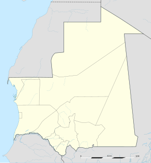
Bassiknou is a town and commune in the Hodh Ech Chargui Region of south-eastern Mauritania.
Gościęcino is a village in the administrative district of Gmina Choczewo, within Wejherowo County, Pomeranian Voivodeship, in northern Poland. It lies approximately 9 kilometres (6 mi) south-west of Choczewo, 29 km (18 mi) west of Wejherowo, and 63 km (39 mi) north-west of the regional capital Gdańsk.
Gościno-Dwór is a village in the administrative district of Gmina Gościno, within Kołobrzeg County, West Pomeranian Voivodeship, in north-western Poland. It lies approximately 16 kilometres (10 mi) south-east of Kołobrzeg and 100 km (62 mi) north-east of the regional capital Szczecin.
Salutaguse is a village in Järva Parish, Järva County in northern-central Estonia.


