
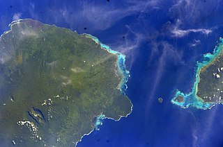
The country of Samoa consists of the two large islands of Upolu and Savai'i and eight smaller islands located about halfway between Hawaii and New Zealand in the Polynesian region of the South Pacific Ocean. The island of Upolu is home to nearly three-quarters of Samoa's population and its capital city of Apia. Samoa occupies an almost central position within Polynesia. The climate is tropical, with a rainy season from November to April. To the east is the smaller American Samoa.
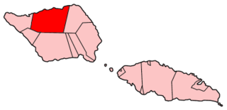
Gaga'ifomauga is a political district on the island of Savai'i in Samoa. The district is situated on the northern side of the island with a population of 4,770.
Palauli is a district and village of Samoa, with a population of 8,984. It consists of two sections on the southern side of Savai'i. The capital is Vailoa which is also referred to as Vailoa i Palauli.

Satupa'itea is a large village district with four sub-villages on the south east coast of Savai'i Island in Samoa.

Vaisigano is a political district at the western tip of Savai'i island in Samoa. The capital of the district is Asau.
Fa'asaleleaga is a district of Samoa situated on the eastern side of Savai'i island. It has a population of 12,949.
Taga is a village on the island of Savai'i in Samoa. It is situated on the south east coast of the island in the district of Palauli.
Lalomalava is a village at the southeast end of Savai'i island in Samoa. The village is part of the electoral constituency Fa'asaleleaga I which is within the larger political district (Itumalo) of Fa'asaleleaga.

Safotulafai is a traditional village at the east end of Savai'i island with historical and political significance in Samoa's history. It is the traditional center of the island of Savaii, now became the center of Fa'asaleleaga political district.
Nu'u is a village on the island of Savai'i in Samoa. It is situated on the south coast of the island in Palauli district.
Siutu is a village on the island of Savai'i in Samoa. It is situated on the southeast coast of the island in Palauli district.
Salelavalu Tai is a village at the east end of Savai'i island in Samoa. The village is part of the electoral constituency Fa'asaleleaga I which is within the larger political district (Itumalo) of Fa'asaleleaga.
Salelavalu Uta is a village at the east end of Savai'i island in Samoa. The village is part of the electoral constituency Fa'asaleleaga I which is within the larger political district (Itumalo) of Fa'asaleleaga.
Vaimaga is a village at the east end of Savai'i island in Samoa. The village is part of the electoral constituency Fa'asaleleaga II which is within the larger political district (Itumalo) of Fa'asaleleaga.
Sa'asa'ai is a village at the east end of Savai'i island in Samoa. The village is part of the electoral constituency Fa'asaleleaga III which is within the larger political district (Itumalo) of Fa'asaleleaga.
Saipipi is a village at the east end of Savai'i island in Samoa. The village is part of the electoral constituency Fa'asaleleaga III which is within the larger political district (Itumalo) of Fa'asaleleaga.
Lano is a village on the north east coast of Savai'i island in Samoa. The village is part of the electoral constituency Fa'asaleleaga IV which is within the larger political district (Itumalo) of Fa'asaleleaga.
Pu'apu'a is a village on the north east coast of Savai'i island in Samoa. The village is part of the electoral constituency Fa'asaleleaga IV which is within the larger political district (Itumalo) of Fa'asaleleaga.
Fogapoa is a village on the north east coast of Savai'i island in Samoa. The village is part of the electoral constituency Fa'asaleleaga II which is within the larger political district (Itumalo) of Fa'asaleleaga.

Lelepa is a village on the north central coast of Savai'i island in Samoa. The village is part of the electoral constituency Gaga'emauga III which forms part of the larger political district of Gaga'emauga.


