Aopo

Last updated
Aopo
Village & Sub-district

ISS004-E-6757 NASA west cetral Savai'i.jpg

Satellite image of Savai'i north west with Asau harbour, lava fields and Aopo inland. (NASA photo, 2002)
Samoa location map.svg
Red pog.svg
Aopo
Coordinates: 13°29′S172°30′W / 13.483°S 172.500°W / -13.483; -172.500
Country Flag of Samoa.svg  Samoa
District Gaga'ifomauga
Population (2006)
  Total 340
Time zone -11

Aopo is a village on the island of Savai'i in Samoa. It is in the political district of Gaga'ifomauga.

Savaii island

Savaiʻi is the largest and highest island in Samoa and the Samoan Islands chain. The island is the fifth largest in Polynesia, behind the two main islands of New Zealand and the Hawaiian Islands of Hawaii and Maui.

Samoa country in Oceania

Samoa, officially the Independent State ofSamoa and, until 4 July 1997, known as Western Samoa, is a country consisting of two main islands, Savai'i and Upolu, and four smaller islands. The capital city is Apia. The Lapita people discovered and settled the Samoan Islands around 3,500 years ago. They developed a unique Samoan language and Samoan cultural identity.

Gagaifomauga District in Samoa

Gaga'ifomauga is a political district on the island of Savai'i in Samoa. The district is situated on the northern side of the island with a population of 4,770.

Contents

The village is located inland from the north coast of Savai'i, close to the main lava field from the island's volcanic cones. There is an Aopo Conservation Area open to visitors and the trail starts at the east end of the village.

Hikers can ascend Mt Silisili, Samoa's highest peak, from Aopo. [1]

Silisili mountain

Mount Silisili is the highest peak in Samoa and the Samoa Islands chain. It is located in the centre of a mountain chain running the length of Savai'i island.

In 2007, Aopo village sold its teak plantation to Blue Bird Lumber. [2]

See also

Faamatai

Fa'amatai is the chiefly system of Samoa, central to the organization of Samoan society. It is the traditional indigenous form of governance in the Samoa Islands, comprising American Samoa and the Independent State of Samoa. The term comprises the prefix fa'a and the word matai.

Samoan is the language of the Samoan Islands, comprising Samoa and the United States territory of American Samoa. It is an official language – alongside English – in both jurisdictions.

Samoans ethnic group

Samoans or Samoan people, are a Polynesian ethnic group native to the Samoan Islands, an archipelago in Polynesia, who speak the Samoan language. The group's home islands are politically and geographically divided between the Independent State of Samoa and American Samoa, an unincorporated territory of the United States of America. Though divided by political powers, the culture and language remains one and the same.

Related Research Articles

Geography of Samoa geography of the Independent State of Samoa (and not American Samoa)

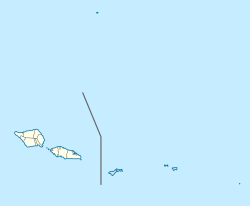
The independent country of Samoa consists of the two large islands of Upolu and Savai'i and 8 smaller islands located about halfway between Hawaii and New Zealand in the Polynesian region of the South Pacific.

Samoan Islands archipelago covering 3,030 km² (1,170 sq mi) in the central South Pacific, forming part of Polynesia and the wider region of Oceania

The Samoan Islands are an archipelago covering 3,030 km2 (1,170 sq mi) in the central South Pacific, forming part of Polynesia and the wider region of Oceania. Administratively, the archipelago comprises all of Samoa and most of American Samoa. The two Samoan jurisdictions are separated by 64 km (40 mi) of ocean.

Salelologa Township & Ferry Terminal in Faasaleleaga, Samoa

Salelologa is a village district at the east end of Savai'i island in Samoa. It is the main entry point into the island with the only ferry terminal on Savai'i. It also serves as the main township for shopping and public amenities with a market selling fresh produce and arts and crafts.

Aiga-i-le-Tai District in Samoa

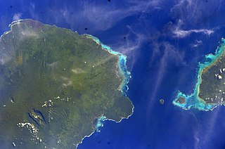
Aiga-i-le-Tai is a district of Samoa which includes the small islands of Manono, Apolima and tiny uninhabited Nu'ulopa lying in the Apolima Strait between the country's two main islands of Upolu and Savai'i.

Gagaemauga District in Samoa

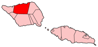
Gaga'emauga is a district on the island of Savai'i in Samoa. The district is situated on the central north side of Savai'i. The name Gaga'emauga literally means "near side of the mountain", meaning the eastern side of the mountain chain running through the centre of Savai'i Island.

Palauli District in Samoa

Palauli is a district and village of Samoa, with a population of 8,984. It consists of two sections on the southern side of Savai'i. The capital is Vailoa which is also referred to as Vailoa i Palauli.

Satupaitea District in Samoa

Satupa'itea is a large village district with four sub-villages on the south east coast of Savai'i Island in Samoa.

Vaisigano District in Samoa

Vaisigano is a political district at the western tip of Savai'i island in Samoa. The capital of the district is Asau.

Faasaleleaga District in Samoa

Fa'asaleleaga is a district of Samoa situated on the eastern side of Savai'i island. It has a population of 12,949.

Apolima Strait strait

The Apolima Strait is about 13 km wide and separates the two largest islands of Samoa, the island of Savai'i to the northwest, and Upolu to the southeast.

Patamea Village in Gagaemauga, Samoa

Patamea is a village on the island of Savai'i in Samoa. While most villages on Savai'i are situated near the sea, Patamea is situated inland, away from the coast. The village is in the Gaga'emauga political district near the central north coast of the island.

Mount Matavanu mountain in Samoa

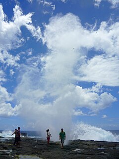
Mt Matavanu is an active volcano on the island of Savai'i in Samoa.

Mata o le Afi is a volcano on the island of Savai'i in the South Pacific nation of Samoa.

Mauna Afi is a volcanic mountain on the island of Savai'i in Samoa. Its name means Burning Mountain or Mountain of Fire, from the Samoan language mauga (mountain) and afi (fire).

Tufutafoe is a village on the island of Savai'i in Samoa. It is situated on the west coast of the island in Vaisigano district.

Samalaeulu

Samalae'ulu is a village on the northeast side of Savai'i island in Samoa. The village is part of the electoral constituency Gaga'emauga I which includes the neighbouring villages of Patamea and the smaller settlement of Mauga which is built around a volcanic crater.

Samoan tropical moist forests

The Samoan tropical moist forests are a tropical moist broadleaf forest ecoregion in the Samoan Islands. They cover an area of 3,100 km2 (1,200 sq mi).

References

  1. Tonga-Samoa handbook by David Stanley, p.151
  2. [ permanent dead link ] Samoa Forestry Outlook Study by Sam Sesega, p.14, Working Paper No. APFSOS II/WP/2009/01,Food and Agriculture Organization of the United Nations Regional Office for Asia and the Pacific.

Coordinates: 13°29′S172°30′W / 13.483°S 172.500°W / -13.483; -172.500

Geographic coordinate system Coordinate system

A geographic coordinate system is a coordinate system that enables every location on Earth to be specified by a set of numbers, letters or symbols. The coordinates are often chosen such that one of the numbers represents a vertical position and two or three of the numbers represent a horizontal position; alternatively, a geographic position may be expressed in a combined three-dimensional Cartesian vector. A common choice of coordinates is latitude, longitude and elevation. To specify a location on a plane requires a map projection.