The Allt Graad or River Glass is a river in Easter Ross, Highland, Scotland. It is named on Ordnance Survey maps variously as Allt Graad and River Glass. It has also been known as the "Allt Grande", and the archaic Anglicization, "Aultgraad".
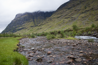
The River Coe rises at the north-eastern base of Buachaille Etive Beag and flows west along Glen Coe, Scotland. After dramatic waterfalls at the Pass of Glen Coe. It runs through the small Loch Achtriochtan before it turns north west. It then runs past the site of the Massacre of Glencoe and passes through Glencoe village, shortly before flowing into the sea loch of Loch Leven at Invercoe.

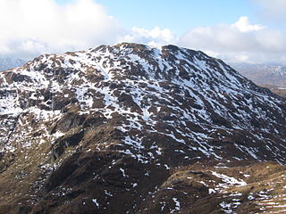
Gaor Bheinn, also known as Gulvain or Culvain, is a mountain in Scotland, to the north of the road west of Fort William, and south of Loch Arkaig. It is composed of banded granite and shaped like a letter Y, with two tops connected by a ridge running from northeast to southwest, with the northern top 6 m higher than the one to the south. Crags drop at either end, and steep slopes fall away to either side.

Stob Coire Easain is a Scottish Munro mountain which reaches a height of 1115 metres (3658 feet), situated 18 kilometres east of Fort William. It stands on the western side of Loch Treig, along with its "twin", the Munro Stob a' Choire Mheadhoin. Collectively the pair are called "The Easains" or the "Stob Corries" and stand just one kilometre apart connected by a high col with an approximate height of 965 metres. The fine corrie of Coire Easain Beag lies in between the two mountains facing north west. Stob Coire Easain’s name translates from the Gaelic as “Peak of the Corrie of the Little Waterfall”. This mountain should not be confused with another Stob Coire Easain, a Munro “Top” on the Munro Stob Coire an Laoigh

Sròn a’ Choire Ghairbh is a Scottish mountain situated on the northern side of Loch Lochy, 13 kilometres north of Spean Bridge in the Highland Council area.
Beinn Chabhair is a Scottish mountain. It has fine views down to Loch Lomond.

Sgùrr Ghiubhsachain is a mountain in the Lochaber area in the west of Scotland. Its summit is the highest point in a group of mountains that stand south of Glenfinnan, to the south east of the northern part of Loch Shiel. It is considerably lower than the nearby Nevis range, but it is a long way from a public road. Its slopes are steep and rugged on all sides and are devoid of paths. Despite easy access to the trail head from the road from Fort William to Mallaig, an individual or party that climbs this mountain may be alone there, even on a fine day in the summer.

Eas a’ Bhradain is a waterfall of Scotland.
Eas Allt an Tairbh is a waterfall on the island of Jura, Scotland.

Linn of Muick is a waterfall on the river Muick, Aberdeenshire, Scotland.

Eas na Dabhaich is a waterfall on the island of Mull in Scotland. The falls lie on a burn that flows from Loch Fraing on the Ross of Mull over high cliffs above Carsaig Bay. There are several more unnamed waterfalls above and along the 200 metres (660 ft) cliffs that stretch from east of Carsaig along to Malcolm's Point and the Carsaig Arches 5 kilometres (3.1 mi) to the west where they are called Aoineadh Mòr and beyond where the height is reduced to about 130 metres (430 ft) and they are known as Aoineadh Beag.
Eas Tardil is a waterfall on the Waternish peninsula of the island of Skye, Scotland. It lies on the Allt Achaidh Bhig, a burn that flows into Loch Snizort to the east. The area is uninhabited and is some 4 kilometres (2.5 mi) east of Stein.
Easan Labhar is a series of waterfalls on the island of Mull, Scotland. It lies on the Allt an Easain Labhair near Gruline west of Salen. There are also unnamed waterfalls on the Allt na Linne burn just to the east.

The River Brora is an east-flowing river in Sutherland in the Highlands of Scotland which is formed as its headwater streams, the Féith Osdail, Allt Gobhlach and Allt nan Con-uisge meet at Dalnessie before flow southeastwards down Strath Brora to Dalreavoch. The river turns briefly northeast then east and then southeastwrads once again to pass through the three distinct basins of Loch Brora to enter the Moray Firth on the North Sea at the town of Brora. Its one principal tributary is the Black Water which enters on its left bank at Balnacoil. The Black Water is itself fed by the River Skinsdale and the Coirefrois Burn.

The River Garry is a major tributary of the River Tummel, itself a tributary of the River Tay, in the traditional county of Perthshire in the Scottish Highlands. It emerges from the northeastern end of Loch Garry (56.8193°N 4.2311°W), just to the southeast of the Pass of Drumochter, and flows southeastwards and eastwards down Glen Garry to the narrow Pass of Killiecrankie beyond which it joins the Tummel (56.7182°N 3.7790°W).

Loch Màma is a small freshwater loch in South Morar, Lochaber, in the north west of Scotland. It forms a simple basin and is orientated east to west. It is thought that the adjoining loch Loch na Creige Duibhe and Loch Màma were at one time a single loch. Debris brought down by the Allt Dearg stream has likely caused the lochs to be separated into two bodies of water. The loch is the source of the river Allt a' Mhama.
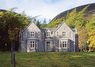
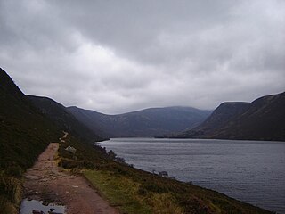
Glas-allt-Shiel is a lodge on the Balmoral Estate by the shore of Loch Muick in Aberdeenshire, Scotland. In its present form it was built in 1868 by Queen Victoria, who called it Glassalt, to be what she called her "widow's house" where she could escape from the world following the death of her husband Albert. It is now a category B listed building owned personally by Elizabeth II. Adam Watson considers that "Glas-allt-Shiel has undoubtedly one of the most spectacular situations of any lodge in the Highlands."

Duchray Water, also called Dachray Water, is a 14-mile-long (23 km) headstream of the River Forth in the Trossachs region of Scotland.

Dubh Loch is a small upland loch situated within the Balmoral Estate, in Aberdeenshire, Scotland. It is at an altitude of 637 metres (2,090 ft), with a perimeter of 2.3 kilometres (1.4 mi), and its outflow, Allt an Dubh-loch, empties into Loch Muick approximately 2 kilometres (1.2 mi) to the southeast near the royal lodge Glas-allt-Shiel. To the southeast of the loch is the Munro Broad Cairn and to the northwest the ground slopes steeply up to Càrn a' Coire Boidheach and Lochnagar. To the west is Cairn Bannoch and over a high col to the southwest lies Loch Callater.