
The Euphrates is the longest and one of the most historically important rivers of Western Asia. Together with the Tigris, it is one of the two defining rivers of Mesopotamia. Originating in the Armenian Highlands of eastern Turkey, the Euphrates flows through Syria and Iraq to join the Tigris in the Shatt al-Arab, which empties into the Persian Gulf.

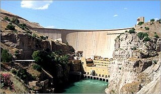
The Tabqa Dam, or al-Thawra Dam as it is also named, most commonly known as Euphrates Dam, is an earthen dam on the Euphrates, located 40 kilometres (25 mi) upstream from the city of Raqqa in Raqqa Governorate, Syria. The city of Al-Thawrah is located immediately south of the dam. The dam is 60 metres (200 ft) high and 4.5 kilometres (2.8 mi) long and is the largest dam in Syria. Its construction led to the creation of Lake Assad, Syria's largest water reservoir. The dam was constructed between 1968 and 1973 with help from the Soviet Union. At the same time, an international effort was made to excavate and document as many archaeological remains as possible in the area of the future lake before they would be flooded by the rising water. When the flow of the Euphrates was reduced in 1974 to fill the lake behind the dam, a dispute broke out between Syria and Iraq that was settled by intervention from Saudi Arabia and the Soviet Union. The dam was originally built to generate hydroelectric power, as well as irrigate lands on both sides of the Euphrates. The dam has not reached its full potential in either of these objectives.

The Keban Dam is a hydroelectric dam on the Euphrates, located in the Elazığ Province of Turkey. The dam was the first and uppermost of several large-scale dams to be built on the Euphrates by Turkey. Although the Keban Dam was not originally constructed as a part of the Southeastern Anatolia Project (GAP), it is now a fully integrated component of the project, which aims to stimulate economic development in Southeastern Turkey. Construction of the dam commenced in 1966 and was completed in 1974. Keban Dam Lake, the reservoir created by Keban Dam, has a surface area of 675 square kilometres (261 sq mi) and is reputedly the fourth-largest lake in Turkey after Lake Van, Lake Tuz, and the reservoir created by the Atatürk Dam.

Copeton Dam is a major clay core and rock fill embankment dam with nine radial gates and a gated concrete chute spillway across the Gwydir River upstream of Bingara in the New England region of New South Wales, Australia. The dam's purpose includes environmental flows, hydro-electric power generation, irrigation, and water supply. The impounded reservoir is called Lake Copeton.

The Haditha Dam or Qadisiya Dam is an earth-fill dam on the Euphrates, north of Haditha (Iraq), creating Lake Qadisiyah. The dam is just over 9 kilometres (5.6 mi) long and 57 metres (187 ft) high. The purpose of the dam is to generate hydroelectricity, regulate the flow of the Euphrates and provide water for irrigation. It is the second-largest hydroelectric contributor to the power system in Iraq behind the Mosul Dam.
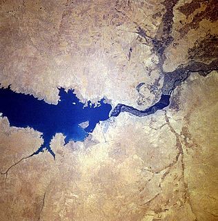
Lake Assad is a reservoir on the Euphrates in Raqqa Governorate, Syria. It was created in 1974 when construction of the Tabqa Dam was completed. Lake Assad is Syria's largest lake, with a maximum capacity of 11.7 cubic kilometres (2.8 cu mi) and a maximum surface area of 610 square kilometres (240 sq mi). A vast network of canals uses water from Lake Assad to irrigate lands on both sides of the Euphrates. In addition, the lake provides drinking water for the city of Aleppo and supports a fishing industry. The shores of Lake Assad have developed into important ecological zones.
The Dukan Dam is a multi-purpose concrete arch dam in As Sulaymaniyah Governorate, Kurdistan Region of Iraq. It impounds the Little Zab, thereby creating Lake Dukan. The Dukan Dam was built between 1954 and 1959 whereas its power station became fully operational in 1979. The dam is 360 metres (1,180 ft) long and 116.5 metres (382 ft) high and its hydroelectric power station has a maximum capacity of 400 MW.

The Ponmudi Dam, in the Idukki district, State of Kerala, India, is a hydroelectric project constructed across the Panniar River, a tributary of the Periyar River which is the longest river in Kerala. Built in 1963, it has a length of 294 metres (965 ft). The hydropower component of the dam has an installed capacity of 30 MW with firm power of 17 MW, generating 158 GWh annually.

The Samarra Barrage is a multi-purpose barrage on the Tigris River adjacent (west) of Samarra and north of Baghdad, Iraq. The main purpose of the dam is to divert floodwater in the Tigris River to Lake Tharthar through the Tharthar depression along with irrigation and an 84 MW hydro-electricity station. It also serves to produce hydroelectric power and flood control – although the later has become less critical with the construction of the Mosul Dam upstream and several other large dams in Turkey.
The Badush Dam is an unfinished multi-purpose dam on the Tigris River, located near Badush, 16 kilometres (9.9 mi) northwest of Mosul in the Ninawa Governorate, northern Iraq.
The Kut Barrage is a barrage on the Tigris river, located in the modern town of Kut in Wasit Governorate, Iraq. It is 516 metres (1,693 ft) long, 10.5 metres (34 ft) high and consists of 56 gates, each 6 metres (20 ft) wide. The maximum discharge of the barrage is 6,000 cubic metres (7,800 cu yd), but actual discharge has not exceeded 2,000 cubic metres (2,600 cu yd) in the last 10 years. The barrage supports a road and includes a lock for boats passing up and down the Tigris. Its purpose is to maintain a sufficiently high water level in the Tigris to provide water for the Gharraf irrigation canal, which branches off the Tigris just upstream from the Kut Barrage. Before the construction of the Kut Barrage, the Gharraf canal only received water during periods of flood in the Tigris. The water level in the canal is maintained by the Gharraf Head Regulator, which was constructed at the same time as the Kut Barrage.
The Hindiya Barrage is located on the Euphrates south of the town of Musayyib in Babil Governorate, Iraq. It was designed by British civil engineer William Willcocks in response to the silting up of the Hillah branch of the Euphrates. Construction of the dam, with a length of over 250 metres (820 ft), lasted between 1911 and 1913. Between 1984 and 1989, a new dam was built several kilometres upstream as a replacement for the Hindiya Barrage.

Durgapur Barrage is built across the Damodar River at Durgapur in Bankura district and partly in Paschim Bardhaman district in the Indian state of West Bengal. It was constructed by Damodar Valley Corporation mainly for the purpose of irrigation and also to supply water to Industrial township of Durgapur. The irrigation and canal system was transferred to the Government of West Bengal in 1964.

Al Wahda Dam, formerly known as M'Jaara Dam, is an embankment dam on the Ouergha River near M´Jaara in Taounate Province, Morocco. It was constructed for flood control, irrigation, water supply and hydroelectric power production. It is the second largest dam in Africa and the largest in Morocco. It was described by Land Ocean Interactions in the Coastal Zone (LOICZ) as "the second most important dam in Africa after the High Aswan dam."

Idamalayar Dam is a multipurpose concrete gravity dam located between Bhoothathankettu and Malakkappara in Ernakulam district of Kerala on the Idamalayar, a tributary of the Periyar River in Kerala, South India. Completed in 1985, with a length of 373 metres (1,224 ft), the dam created a multipurpose reservoir covering 28.3 km2 (10.9 sq mi) in the scenic hills of the Anamalais.

Zengwen Dam, also spelled Tsengwen Dam, is a major earthen dam in Dapu Township, Chiayi County, Taiwan on the Zengwen River. It is the third tallest dam in Taiwan, and forms Zengwen Reservoir (曾文水庫), the biggest reservoir in Taiwan by volume. The dam stores water for irrigation of the Chianan Plain, Taiwan's most productive agricultural region, and provides flood control along the Zengwen River which flows through Tainan City. The dam supports a 50 megawatt hydroelectric power station.

Kotri Barrage, also known as the Ghulam Muhammad Barrage, is a barrage on the Indus River between Jamshoro and Hyderabad in the Sindh province of Pakistan. The barrage was completed in 1955 and was inaugrated by Ghulam Muhammad. It is used to control water flow in the Indus for irrigation and flood control purposes.

The Pazhassi Dam also called Kulur Barrage is a stone masonry diversion structure in Kannur district, Kerala, India. It is named after king Pazhassi Raja, a patriot who died a heroic death in the war. The dam is constructed across the west flowing Bavali river near Veliyambra. It was commissioned by Prime Minister Morarji Desai in 1979. It mainly functions as an irrigation dam, serving a command area of 11,525 hectares in Thalassery and Taliparamba taluks of the Kannur District. The water from this dam also meets the drinking water requirement of Kannur district. The dam site and the reservoir are famous for their scenic beauty.

The Kanjirapuzha Dam, a masonry earth dam built for providing irrigation to a Cultural Command Area (CCA) of 9,713 hectares, is located in the Palakkad district in the Indian state of Kerala. The reservoir, which has three islands within it, also has an established commercial fisheries development programme operated by the Fisheries Department.

